Auniontech SKYSPEC Open-Path Remote Sensing Gas Analyzer
| Brand | Auniontech |
|---|---|
| Origin | Shanghai, China |
| Manufacturer Type | Authorized Distributor |
| Product Category | Domestic |
| Model | SKYSPEC Series |
| Pricing | Available Upon Request |
Overview
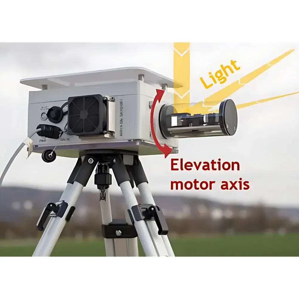
The Auniontech SKYSPEC Open-Path Remote Sensing Gas Analyzer is a field-deployable differential optical absorption spectroscopy (DOAS) instrument engineered for quantitative, non-invasive monitoring of trace atmospheric gases and aerosols over extended path lengths. Operating in the ultraviolet–visible (UV–Vis) spectral range (280–650 nm), it captures direct solar irradiance and scattered skylight spectra through a motorized, elevation- and azimuth-adjustable telescope system. By applying DOAS retrieval algorithms—based on high-resolution reference cross-sections and polynomial baseline correction—the analyzer quantifies column densities (molecules/cm²) of key species including NO₂, SO₂, O₃, HCHO, H₂O, HONO, BrO, IO, glyoxal, and O₄. Its temperature-stabilized, grating-based spectrometer delivers sub-nanometer spectral resolution (< 0.3 nm FWHM), enabling robust separation of overlapping absorption features under variable ambient conditions. Designed for unattended operation in outdoor environments, the SKYSPEC platform supports both passive sun-tracking and zenith-sky scanning modes, with real-time elevation compensation via integrated tilt sensors.
Key Features
- Motorized dual-axis telescope (elevation and azimuth) with automated pointing accuracy ±0.1° and repeatability < 0.05°
- Compact, ruggedized spectrometer housing featuring active thermal stabilization (±0.1°C control) to minimize wavelength drift
- Low-stray-light optical design with narrow field-of-view (FOV ≈ 0.5°) optimized for high signal-to-noise ratio (SNR > 1000:1 at 400 nm)
- Integrated wide-angle monitoring camera for real-time alignment verification and environmental context logging
- Weather-resistant enclosure rated IP65, operational from −20 °C to +50 °C with minimal external moving parts
- High spectral sampling density (> 2048 pixels across UV–Vis range) supporting advanced spectral fitting and residual analysis
- Automated elevation correction using onboard MEMS tilt sensors, eliminating manual leveling requirements
Sample Compatibility & Compliance
The SKYSPEC analyzer is designed for open-path atmospheric sampling—requiring no sample extraction, inlet tubing, or calibration gases. It measures integrated column abundances along line-of-sight paths ranging from 100 m to several kilometers, depending on atmospheric transparency and target gas concentration. Instrument performance complies with principles outlined in ISO 17125-1:2022 (spectral measurement systems) and adheres to best practices for ground-based remote sensing as recommended by the World Meteorological Organization (WMO) Global Atmosphere Watch (GAW) program. Data processing workflows support traceability per GLP-compliant laboratory practices; raw spectra are stored in HDF5 format with embedded metadata (time stamp, GPS coordinates, temperature, pressure, humidity, telescope pointing angles). While not FDA 21 CFR Part 11 certified (as it is a research-grade environmental monitor), the system enables audit-ready data export for regulatory reporting frameworks such as EU Directive 2008/50/EC on ambient air quality.
Software & Data Management
The SKYSPEC system ships with proprietary DOAS analysis software (SKYSPEC Analysis Suite v3.x), providing end-to-end spectral acquisition, calibration, fitting, and visualization. Core modules include: (1) real-time spectral preview and quality control flags; (2) interactive DOAS fitting with customizable polynomial orders and interference masking; (3) multi-species simultaneous retrieval using least-squares optimization; (4) vertical profile inversion capability via optimal estimation (OE) when combined with radiative transfer modeling (e.g., SCIATRAN or LIDORT); (5) time-series plotting, map overlays (via WGS84 georeferencing), and batch processing for long-term trend analysis. All processed results—including slant column densities, air mass factors (AMFs), and derived vertical column densities—are exportable in CSV, NetCDF, and MATLAB-compatible formats. Software logs full audit trails (user actions, parameter changes, version stamps) and supports configurable data retention policies aligned with institutional data management plans.
Applications
- Long-term monitoring of urban and industrial emissions (e.g., NO₂ plumes from traffic corridors or SO₂ from coal-fired power plants)
- Volcanic gas surveillance (SO₂ flux mapping during eruptive activity)
- Validation of satellite-based atmospheric retrievals (e.g., TROPOMI, OMI, GEMS)
- Field campaigns for atmospheric chemistry studies (e.g., HOₓ radical precursor detection via HONO and formaldehyde)
- Boundary-layer profiling of ozone and aerosol extinction using multi-angle sky scans
- Educational deployment in university atmospheric science labs for hands-on DOAS methodology training
FAQ
What spectral resolution does the SKYSPEC spectrometer achieve?
The spectrometer delivers sub-nanometer resolution, typically ≤ 0.3 nm full-width-at-half-maximum (FWHM) across the 280–650 nm range, validated via mercury-argon lamp line calibration.
Can the system operate autonomously for unattended field deployments?
Yes—integrated GPS, environmental sensors, and programmable scan sequences enable fully autonomous operation for up to 30 days with external power and data telemetry (e.g., 4G/LTE or satellite link).
Is calibration required before each measurement campaign?
No routine recalibration is needed; the system uses internal wavelength reference lines and factory-characterized detector response. Annual verification against NIST-traceable standards is recommended.
Does the software support third-party spectral databases?
Yes—users may import custom cross-sections (e.g., from GEISA, HITRAN, or JPL evaluations) and define new fitting species within the analysis suite.
What is the minimum detectable column density for NO₂ under typical conditions?
Detection limits vary with integration time and solar elevation but typically reach 1 × 10¹⁵ molecules/cm² for 5-minute integrations at solar zenith angles < 60°.