AZUP AM-IoT100 All-Weather Autonomous UAV Remote Sensing & Telemetry System
| Brand | AZUP |
|---|---|
| Origin | Beijing, China |
| Manufacturer Type | OEM/ODM Producer |
| Country of Origin | China |
| Model | AM-IoT100 |
| Pricing | Upon Request |
Overview
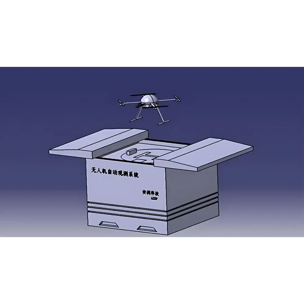
The AZUP AM-IoT100 All-Weather Autonomous UAV Remote Sensing & Telemetry System is an integrated, industrial-grade environmental monitoring platform engineered for unattended, long-term deployment in remote or hazardous ecological zones. It operates on a tripartite architecture—autonomous multirotor UAV, intelligent outdoor hangar (IoT Hangar), and secure cloud-based IoT telemetry platform—enabling end-to-end automation from mission planning to data ingestion. The system employs physical-layer sensor fusion and heterogeneous redundancy across navigation, communication, and perception subsystems to ensure operational continuity under variable meteorological conditions. Its core measurement paradigm combines georeferenced multispectral imaging, thermal radiometry, and high-resolution visible-light photogrammetry, all synchronized with real-time GNSS-RTK positioning (≤1 cm horizontal, ≤2 cm vertical) and inertial navigation. Designed explicitly for ecological and environmental remote sensing applications—including wetland dynamics mapping, forest canopy stress assessment, and post-disaster land cover change detection—the AM-IoT100 complies with foundational data integrity requirements aligned with ISO 19115 metadata standards and supports traceable audit trails required under GLP-compliant field monitoring protocols.
Key Features
- Fully autonomous flight cycle: automatic takeoff, waypoint-based 3D route execution, precision landing (≤10 cm CEP), and in-hangar battery recharging without human intervention
- Dual-satellite navigation architecture: RTK-GNSS + standalone GPS with dual-antenna heading determination and magnetometer cross-validation
- Heterogeneous IMU redundancy: two independent inertial measurement units with calibrated bias drift compensation
- Dual-link telemetry: simultaneous 4G LTE cellular and dedicated UHF data link for failover-capable command-and-control
- Forward-facing stereo vision system: real-time obstacle detection and avoidance during forward flight; vision-aided landing guidance under low-visibility conditions
- IP54-rated outdoor hangar: temperature- and humidity-controlled enclosure (-30°C to +60°C operating range), integrated five-element meteorological station (wind speed/direction, ambient temperature, relative humidity, pressure), and 360° panoramic surveillance camera
- Modular smart battery system: hot-swappable LiPo packs with SOC telemetry, automated charging sequencing, and thermal management
- Centimeter-level docking precision: visual-inertial odometry (VIO) fused with RTK position feedback for repeatable landing alignment
Sample Compatibility & Compliance
The AM-IoT100 accommodates interchangeable electro-optical payloads including visible-light RGB cameras (≥20 MP), uncooled microbolometer thermal imagers (640 × 512 resolution), hyperspectral push-broom sensors (400–1000 nm, 5 nm FWHM), and dual-band (MWIR/LWIR) radiometric modules. Payload interfaces conform to MAVLink v2.0 and STANAG 4609-compliant metadata embedding. System-level compliance includes CE RED Directive 2014/53/EU for radio equipment, RoHS 2011/65/EU, and adherence to ICAO Annex 10 Vol IV for UAV command-link security. Data acquisition workflows support ISO/IEC 17025-aligned uncertainty documentation for derived geospatial products and are compatible with US EPA’s AQS-10 environmental data submission schema.
Software & Data Management
The AZUP IoT Cloud Platform provides role-based access control (RBAC), TLS 1.3 encrypted telemetry channels, and full audit logging per FDA 21 CFR Part 11 Annex 11 principles. Mission planning supports KML/SHP import, no-fly zone geofencing, and dynamic weather-aware route optimization. All flight logs—including GNSS raw measurements, IMU time-series, payload trigger timestamps, and battery telemetry—are stored in ISO/IEC 27001-certified object storage with SHA-256 hash integrity verification. Raw imagery undergoes automated orthorectification using onboard RTK-IMU pose data and optional ground control point (GCP) integration. Export formats include GeoTIFF, NetCDF4 (for spectral cubes), and CSV with embedded WGS84 coordinates and sensor calibration parameters.
Applications
- Long-term ecological monitoring: phenology tracking, invasive species spread assessment, and soil moisture estimation via NDVI and Tasseled Cap transformation
- Regulatory compliance reporting: EPA NPDES permit monitoring, landfill leachate plume mapping, and coastal erosion quantification
- Disaster response coordination: rapid flood extent delineation, wildfire perimeter tracking, and post-earthquake infrastructure damage classification
- Smart agriculture integration: irrigation scheduling support through canopy temperature differentials and chlorophyll index derivation
- Urban heat island studies: high-resolution surface temperature mapping coupled with building footprint GIS layers
FAQ
Does the AM-IoT100 support third-party payload integration?
Yes—payloads must comply with MAVLink 2.0 message definitions and provide standardized power/control interfaces (e.g., CAN bus or UART). AZUP offers SDK documentation and hardware abstraction layer (HAL) reference designs.
What level of cybersecurity is implemented in the IoT Cloud Platform?
The platform enforces OAuth 2.0 authentication, end-to-end AES-256 encryption for data at rest and in transit, and quarterly penetration testing per NIST SP 800-115 guidelines.
Can the system operate in rain or snow?
The UAV is rated IP43 and the hangar IP54; operation is permitted in light precipitation (<2 mm/h), but sustained rain or snowfall exceeding 5 mm/h triggers automatic mission suspension per internal weather threshold logic.
Is historical flight data exportable for regulatory submission?
Yes—raw binary logs, processed geotiffs, and metadata JSON bundles can be exported in ZIP archives with digital signature verification and timestamped audit records.
How is firmware updated across distributed units?
Over-the-air (OTA) updates are delivered via signed differential packages through the cloud platform, requiring dual-signature approval from system administrators before installation on UAV or hangar controllers.
Related Products


