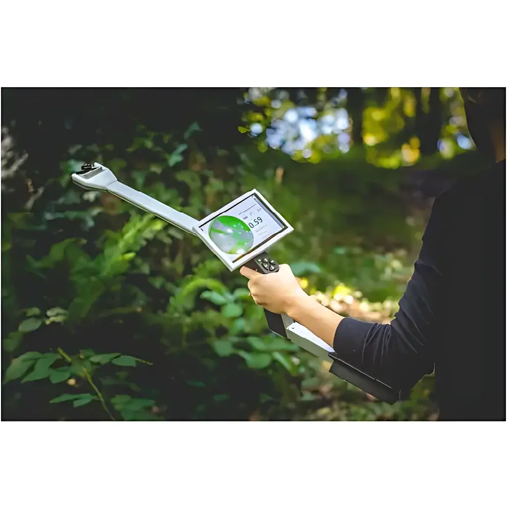
CI-110 Canopy Analyzer for Plant Physiology and Ecology
| Origin | USA |
|---|---|
| Manufacturer Type | Authorized Distributor |
| Origin Category | Imported Instrument |
| Model | CI-110 |
| Price Range | USD 7,200 – 14,400 (FOB) |
| Measurement Principle | Hemispherical Photography with Digital Image Analysis |
| Instrument Type | Handheld Portable System |
| Camera Sensor | 8-MP CCD |
| Fisheye Lens Field of View | 150° |
| Display | 7-inch Capacitive Touchscreen with 6 Dedicated Function Keys |
| Measurement Time | ≤0.5 s per image |
| PAR Sensors | 24-channel Quantum Sensors (400–700 nm) mounted on handle |
| Operating Temperature | 5–50 °C |
| Relative Humidity Range | 0–100% RH (non-condensing) |
| Handle Length | 400 mm |
| Battery Life | Up to 6 hours continuous operation |
| GPS Module | Integrated with Compass and Geotagging Support |
| Software Features | Automatic & Manual Thresholding (Otsu algorithm), Zenith/Azimuthal Grid Partitioning (10×10), Sky/Leaf Color Filtering, Shadow Masking, LAI/MLA/Transmission Coefficient/Extinction Coefficient/Leaf Angle Distribution Calculation, Sunfleck Detection, PAR Integration |
Overview
The CI-110 Canopy Analyzer is a field-deployable, handheld instrument engineered for quantitative structural and radiative characterization of plant canopies using hemispherical photography. It operates on the principle of fisheye-lens-based digital imaging, capturing a full 150° hemispherical view of the canopy from beneath in a single exposure. Unlike traditional energy-based methods requiring repeated diurnal measurements under varying solar angles, the CI-110 enables rapid, single-shot acquisition—eliminating dependency on clear-sky conditions and eliminating the need for separate sky-reference images. Its integrated 24-channel PAR quantum sensor array simultaneously records incident photosynthetic photon flux density (PPFD) at the measurement plane, enabling concurrent calculation of light transmission metrics—including direct-beam transmittance, diffuse transmittance, and sunfleck frequency—without external data logging hardware. The system’s auto-leveling optical platform ensures geometrically consistent image acquisition across heterogeneous terrain, while its ruggedized enclosure meets IP54 environmental protection standards for sustained use in agricultural fields, forest understories, and alpine ecotones.
Key Features
- True hemispherical imaging with fixed-focus 150° fisheye lens optimized for canopy geometry reconstruction
- 8-megapixel high-dynamic-range CCD sensor with real-time JPEG compression and onboard storage (≥2,000 images)
- Integrated 24-point PAR sensor array calibrated to NIST-traceable standards (400–700 nm spectral response)
- Self-leveling gimbal mechanism ensuring orthogonal image orientation independent of operator tilt
- 7-inch sunlight-readable capacitive touchscreen with glove-compatible interface and six tactile function keys
- Embedded GPS + digital compass for georeferenced, repeatable plot-level monitoring across growing seasons
- On-device image preview, threshold adjustment, and preliminary LAI estimation prior to data export
- Battery-powered architecture supporting >6 hours of continuous operation under typical field conditions
Sample Compatibility & Compliance
The CI-110 accommodates a broad morphological range—from low-stature herbaceous canopies (e.g., wheat, soybean, alfalfa) to multi-layered forest stands (e.g., temperate deciduous, tropical secondary growth). Its adjustable focus ring allows optimal resolution across vertical strata (0.3–30 m above ground), supporting shrub, sapling, and mature tree crown analysis without accessory modification. All hardware and firmware comply with FCC Part 15 Class B and CE RED Directive 2014/53/EU electromagnetic compatibility requirements. Data acquisition protocols align with ISO 11727:2017 (optical measurement of vegetation structure) and ASTM E2913-22 (standard practice for estimating leaf area index via hemispherical photography). Software output formats (CSV, GeoTIFF, XML) support interoperability with GIS platforms and statistical modeling environments compliant with FAO’s Agroecological Zoning Framework.
Software & Data Management
The proprietary CI-Analyzer software (v5.2+, Windows/macOS compatible) implements a dual-mode image processing pipeline: automated Otsu thresholding for rapid batch analysis and interactive manual segmentation for validation-critical applications. Users define zenith angle (0–90°) and azimuthal (0–360°) grids up to 10×10 resolution to compute angularly resolved transmission coefficients, extinction coefficients (k), and mean leaf angle (MLA). Advanced masking tools allow exclusion of non-canopy artifacts—including operator shadows, overhead wires, and cloud patches—based on chromaticity or spatial morphology. All analyses retain full audit trail metadata: timestamp, GPS coordinates, sensor ID, battery voltage, and user-defined annotation tags. Exported datasets include LAI, gap fraction, clumping index (Ω), sunfleck duration/intensity histograms, and PAR-integrated daily totals—all structured to meet GLP-compliant record retention requirements per 21 CFR Part 11 Annex 11.
Applications
The CI-110 supports longitudinal studies in agronomy, silviculture, and ecosystem ecology where canopy architecture governs resource capture efficiency. In precision agriculture, it quantifies LAI dynamics to calibrate NDVI-based yield models and optimize nitrogen application timing. Forestry researchers employ its sunfleck detection capability to assess understory light regimes influencing seedling recruitment and species turnover in mixed-species stands. Ecophysiologists use its MLA and extinction coefficient outputs to parameterize radiative transfer models (e.g., SAIL, 4SAIL) for carbon assimilation forecasting. Its portability and weather independence make it suitable for remote monitoring campaigns across climatic gradients—from semi-arid grasslands (e.g., Loess Plateau studies) to montane cloud forests—enabling cross-site comparisons of canopy plasticity under climate stress.
FAQ
Does the CI-110 require calibration against a reference standard before each use?
No. The fisheye lens is factory-calibrated for geometric distortion correction; PAR sensors are pre-traceable to NIST SRM 2253. A single annual verification using certified neutral-density filters and quantum meter cross-check is recommended per ISO/IEC 17025.
Can the CI-110 operate under overcast or fully diffuse lighting conditions?
Yes. Hemispherical photography relies on spatial pattern recognition—not absolute irradiance—so LAI and gap fraction remain quantitatively valid regardless of sky condition. PAR sensor data remains accurate under all daylight conditions.
Is GPS data embedded directly into image EXIF headers?
Yes. Geotags are written to JPEG metadata during acquisition, enabling automated spatial indexing in QGIS or ArcGIS without post-processing.
How does the software handle partial obstruction (e.g., branches, poles) in the hemispherical image?
Users apply polygonal or brush-based masking tools to exclude obstructing elements prior to thresholding, preserving analytical integrity without compromising statistical representativeness.
What file formats does the software export for integration with R or Python workflows?
CSV (tabular metrics), GeoTIFF (gridded gap fraction), and XML (full metadata + pixel-level binary masks) are natively supported; Python API access is available via RESTful endpoints in enterprise license tiers.


