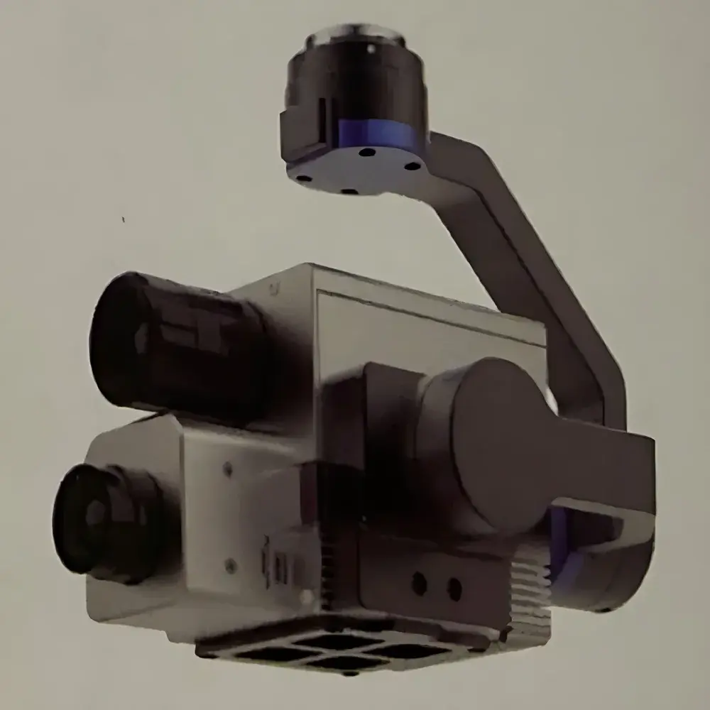
Corning 410-IR Integrated Hyperspectral Infrared Imaging System
| Brand | Corning |
|---|---|
| Origin | Beijing, China |
| Manufacturer Type | Authorized Distributor |
| Product Origin | Domestic (China) |
| Model | 410-IR |
| Price | USD 118,000 (FOB Beijing) |
| Operating Principle | Push-broom scanning |
| Platform Compatibility | Ground-based and airborne deployment |
| Spectral Range | 7.5–13.5 µm (MWIR/LWIR) + 400–1000 nm (VIS-NIR) |
| Frame Rates | 100, 120, 160, 200, 220, 240, or 300 Hz (software-selectable, auto-synchronized with platform velocity) |
Overview
The Corning 410-IR Integrated Hyperspectral Infrared Imaging System is a field-deployable, dual-band push-broom spectrometer engineered for simultaneous acquisition of calibrated hyperspectral data across the visible–near-infrared (VIS-NIR: 400–1000 nm) and mid-to-long-wave infrared (MWIR/LWIR: 7.5–13.5 µm) spectral domains. Unlike conventional multispectral or single-band thermal imagers, the 410-IR employs two physically co-registered optical paths—each optimized for its respective spectral region—enabling pixel-aligned spectral cubes with intrinsic geometric and radiometric consistency. Its push-broom architecture ensures high spatial fidelity without motion blur, making it suitable for both stabilized ground platforms (e.g., tripod-mounted survey rigs, vehicle-mounted masts) and dynamic airborne deployments—including integration with DJI Matrice 300 RTK UAVs via the Skyport electronic interface. The system’s core optical design incorporates high-efficiency reflective diffraction gratings and quantum-efficient focal plane arrays (FPAs), delivering high spectral throughput, low stray light, and robust spectral fidelity under variable ambient conditions.
Key Features
- Dual-band synchronized acquisition: Simultaneous capture of VIS-NIR and MWIR/LWIR hyperspectral cubes with sub-pixel spatial registration.
- Integrated inertial navigation system (INS): Provides real-time attitude, position, and angular rate data for georeferencing and motion compensation.
- Embedded ARM-based processing unit: Executes on-board radiometric calibration, dark current subtraction, and non-uniformity correction (NUC) prior to storage.
- High-speed solid-state storage: Internal NVMe SSD supports sustained write rates >320 MB/s, enabling full-frame recording at up to 300 Hz in selected band subsets.
- Configurable frame rate selection: Seven discrete frame rates (100–300 Hz) are software-selectable and automatically synchronized to platform velocity for optimal ground sampling distance (GSD) control.
- Thermal imaging module: Uncooled microbolometer array (640 × 512 pixels) with ±1 °C absolute temperature accuracy across full frame; supports radiometric video export and thermal mosaic generation.
- Skyport-compatible gimbal interface: Plug-and-play integration with DJI M300 RTK; includes active stabilization, real-time telemetry feedback, and power-over-ethernet (PoE) support.
Sample Compatibility & Compliance
The 410-IR does not require sample preparation or contact, operating in passive, standoff mode across distances ranging from 1 m (ground survey) to 1000 m (airborne mapping). It is compliant with ISO 18434-1:2008 (condition monitoring — thermography) for quantitative thermal analysis and meets the optical alignment and calibration traceability requirements outlined in ASTM E1933-19 (Standard Test Methods for Measuring and Compensating for Emissivity Using Infrared Imaging Systems). Radiometric calibration is performed using NIST-traceable blackbody sources at factory and optionally in-field via integrated shutter-based reference calibration. Data output formats adhere to ENVI-compatible BIL/BIP and HDF5 standards, ensuring interoperability with third-party GIS and spectral analysis toolchains (e.g., Specim INSIGHT, ENVI, Python scikit-image + h5py).
Software & Data Management
The system ships with Corning Hyperspectral Acquisition Suite (CHAS) v3.x, a Windows-based application supporting real-time preview, spectral library matching (via built-in USGS, JPL, and custom mineral/vegetation libraries), and batch radiometric correction. CHAS implements audit-trail logging per FDA 21 CFR Part 11 requirements—including user authentication, electronic signatures, and immutable metadata embedding—for regulated environmental monitoring and industrial QA/QC applications. Raw data is stored in radiometrically corrected, geotagged format with embedded INS metadata (latitude, longitude, altitude, pitch, roll, yaw, timestamp). Users may define spectral sub-bands during acquisition to reduce file size without post-processing—ideal for long-duration UAV missions where onboard storage and downlink bandwidth are constrained.
Applications
- Mineralogical mapping and lithological classification in open-pit mining and geological surveying.
- Vegetation stress detection and species discrimination via combined chlorophyll absorption (VIS-NIR) and canopy temperature anomalies (LWIR).
- Industrial infrastructure inspection: Detection of thermal bridging, insulation defects, and electrical hotspots in solar farms, substations, and building envelopes.
- Environmental monitoring: Methane plume identification (using LWIR spectral features near 7.7 µm), wildfire perimeter tracking, and post-fire burn severity assessment.
- Defense and security: Camouflage detection, concealed object identification, and persistent surveillance under low-visibility conditions.
FAQ
Is the 410-IR compatible with non-DJI UAV platforms?
Yes—while optimized for DJI M300 RTK via Skyport, the system supports generic CAN/RS422 and MAVLink interfaces for integration with other UAV autopilots (e.g., Pixhawk, Auterion) using optional adapter modules.
Does the system support real-time onboard spectral analysis?
Basic spectral indexing (e.g., NDVI, NDWI, TIR emissivity ratio) is computed in real time; advanced algorithms (e.g., spectral unmixing, endmember extraction) require post-processing in CHAS or external environments.
What is the calibration interval recommendation?
Factory calibration is valid for 12 months under normal operating conditions; field recalibration using the internal shutter and external blackbody is recommended every 90 days for quantitative thermal applications.
Can raw interferometric or Fourier-transform data be exported?
No—the 410-IR is a dispersive push-broom imager, not an FTIR system; all outputs are calibrated reflectance/radiance spectra in wavelength-space format.
Is GLP/GMP-compliant documentation available for regulatory submissions?
Yes—full IQ/OQ/PQ protocols, calibration certificates, and 21 CFR Part 11 compliance reports are provided upon request for pharmaceutical, aerospace, and environmental regulatory use cases.
")