Davis Instruments Vantage Pro 2 Wireless Weather Station
| Origin | USA |
|---|---|
| Manufacturer Type | Authorized Distributor |
| Origin Category | Imported |
| Model | Vantage Pro 2 |
| Instrument Type | Portable Weather Station |
| Wind Speed Range | 1–67 m/s, Accuracy: ±5% |
| Barometric Pressure Range | 880–1080 hPa, Accuracy: ±1.0 hPa, Resolution: 0.1 hPa |
| Wind Direction Range | 0–360°, Accuracy: ±7°, Resolution: 1° |
| Air Temperature Range | −40 to +65 °C, Accuracy: ±0.5 °C, Resolution: 0.1 °C |
| Relative Humidity Range | 0–100%, Accuracy: ±3%, Resolution: 1% |
| Rainfall Range (Daily) | 0–9999 mm, Accuracy: ±4%, Resolution: 0.2 mm |
| Solar Radiation Range | 0–1800 W/m², Spectral Response: 300–1100 nm, Accuracy: ±5%, Resolution: 1 W/m² |
| UV Radiation Range | 0–199 MEDs, Spectral Response: 290–390 nm, Accuracy: ±5%, Resolution: 0.1 MEDs |
| Soil Temperature Range | −40 to +65 °C, Accuracy: ±0.5 °C, Resolution: 1 °C |
| Leaf Wetness Range | 0–15 units, Accuracy: ±0.5, Resolution: 1 unit |
| Soil Moisture Range | 0–200 cb, Resolution: 1 cb |
| Dew Point Range | −76 to +54 °C, Accuracy: ±1.5 °C, Resolution: 1 °C |
| ET Calculation | Daily/Monthly/Annual, Resolution: 0.1 mm, Accuracy: ±5% |
| Operating Temperature (Console) | −40 to +70 °C |
| Memory Capacity | 128 KB non-volatile |
| Sampling Intervals | 1, 5, 10, 15, 30, 60, or 120 minutes |
| Wireless Transmission Range | Up to 300 m (line-of-sight), typical 60–120 m (obstructed) |
Overview
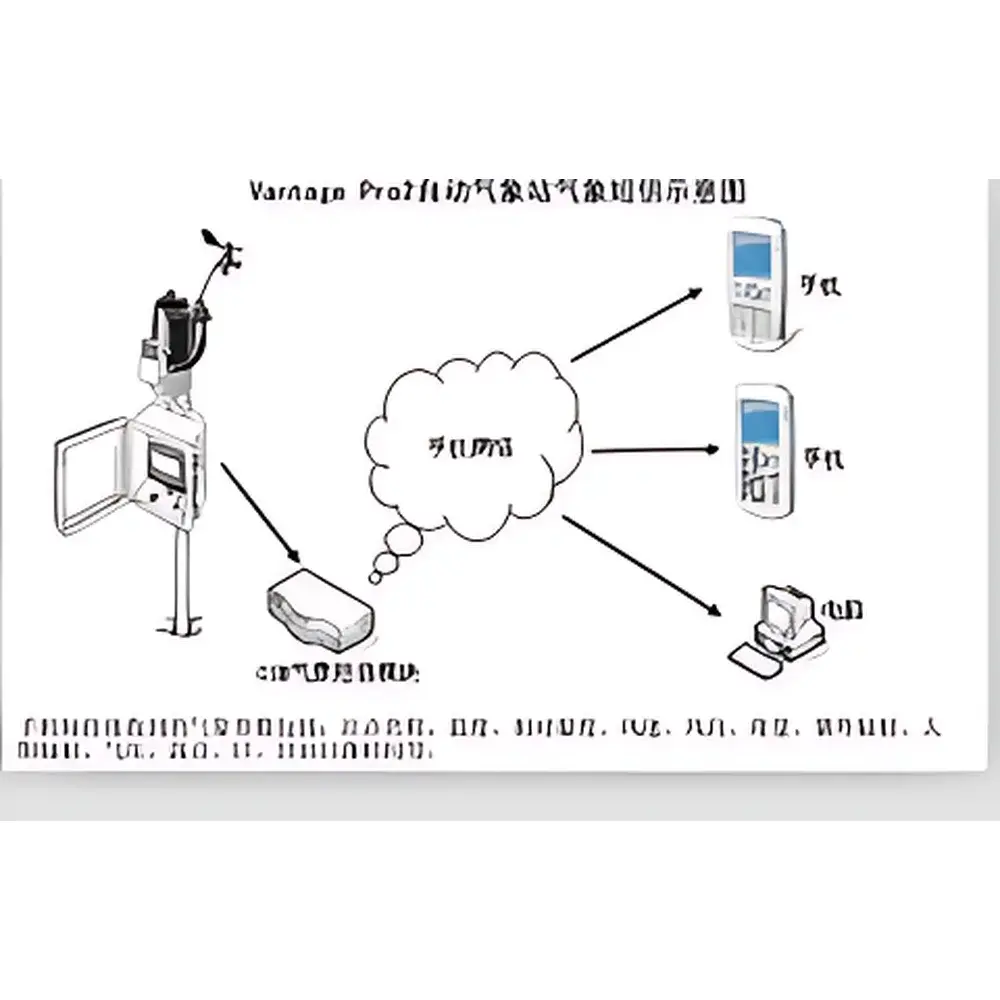
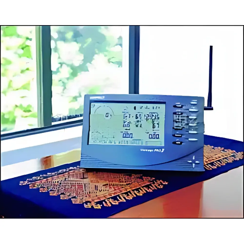
The Davis Instruments Vantage Pro 2 Wireless Weather Station is a field-deployable, integrated environmental monitoring system engineered for high-reliability meteorological data acquisition across diverse operational environments—from agricultural research plots and university field stations to municipal climate networks and ecological observatories. Built upon a proven sensor architecture validated under ASTM D5098 (Standard Practice for Calibration of Environmental Sensors) and aligned with NOAA’s Surface Observation Standards, the Vantage Pro 2 employs physically separated, calibrated transducers for wind vector measurement (cup anemometer and vane), thermistor-based air temperature and humidity sensing (with radiation-shielded housing), tipping-bucket rain gauge, solid-state barometric pressure transducer, and photodiode-based solar and UV radiometers. All sensors feed into a centralized console via proprietary 915 MHz FHSS (Frequency-Hopping Spread Spectrum) wireless protocol, eliminating conduit requirements while maintaining signal integrity in electrically noisy or topographically complex terrain. The system supports continuous autonomous operation powered by solar-charged lithium battery, with onboard 128 KB non-volatile memory ensuring data persistence during extended communication outages.
Key Features
- Integrated wireless console with backlit graphical LCD display supporting real-time parameter visualization, trend graphs, and alarm thresholds
- Modular sensor architecture enabling field-configurable expansion: optional soil moisture (capacitance-based), soil temperature (PT1000), leaf wetness (resistive grid), and evapotranspiration (ET) calculation modules
- NOAA-compliant data logging firmware generating standardized METAR- and CLIMAT-formatted reports for regulatory submission and interoperability with national weather databases
- Dual-mode connectivity: native USB interface for local WeatherLink data download; optional GPRS/CDMA cellular module (sold separately) for IP-based telemetry to cloud platforms or institutional servers
- WeatherLink Live compatibility enabling TLS-encrypted HTTPS data streaming, remote firmware updates, and integration with third-party SCADA or IoT middleware (e.g., MQTT, REST API)
- IP65-rated outdoor enclosure options for console deployment in unsheltered locations; NEMA 4X-compatible mounting hardware included
Sample Compatibility & Compliance
The Vantage Pro 2 is designed for long-term exposure to ambient atmospheric conditions per IEC 60529 (IP65) and UL 61010-1 safety standards. Sensor calibration traceability follows NIST-traceable protocols, with factory-certified accuracy maintained over specified operating ranges. Data output formats comply with WMO No. 8 (Guide to Meteorological Instruments and Methods of Observation) Annex 4.1 for surface station reporting. When configured with WeatherLink software and enabled audit trails, the system supports GLP/GMP-aligned data integrity requirements—including electronic signature capability, user access control, and immutable timestamped logs—meeting FDA 21 CFR Part 11 readiness criteria for regulated environmental monitoring applications.
Software & Data Management
WeatherLink software (v6.0+) provides full configuration, calibration offset management, and historical data analysis with customizable export to CSV, XML, or NetCDF formats. The console’s internal memory stores up to 128 KB of time-stamped records (equivalent to ~12 months at 15-minute intervals). For enterprise-scale deployments, WeatherLink Live enables role-based user permissions, automated backup to AWS S3 or on-premise NAS, and integration with GIS platforms via GeoJSON metadata tagging. All data transmissions are secured using TLS 1.2+ encryption, and audit logs record every configuration change, sensor recalibration event, and user login session—ensuring full chain-of-custody compliance.
Applications
- Agricultural water management: Real-time ET estimation and irrigation scheduling based on FAO-56 Penman-Monteith methodology
- Ecological phenology studies: Correlation of leaf wetness duration, soil moisture hysteresis, and microclimate gradients with plant disease onset models
- Renewable energy site assessment: High-resolution solar irradiance and wind resource profiling for PV and small-wind feasibility analysis
- Urban heat island monitoring: Distributed deployment across city zones to map thermal gradients and validate mesoscale model outputs
- Educational STEM programs: Curriculum-aligned datasets for atmospheric science labs, including diurnal cycle analysis, dew point depression modeling, and UV index forecasting
FAQ
What is the maximum recommended cable length between sensors and console?
Sensor-to-console wired connections (e.g., for soil probes or external temperature/humidity units) support up to 300 meters using shielded twisted-pair cabling meeting RS-485 electrical specifications.
Does the system meet regulatory requirements for environmental reporting?
Yes—the Vantage Pro 2 generates NOAA-standardized reports and, when used with WeatherLink Live and configured audit settings, satisfies documentation requirements for ISO 14001 environmental management systems and EPA Tier II reporting frameworks.
Can data be accessed remotely without cellular infrastructure?
Yes—via optional Ethernet or Wi-Fi bridge adapters (not included), enabling LAN-based access and integration with local network time servers for precise timestamp synchronization.
Is calibration verification supported in-field?
The console includes built-in diagnostic routines for sensor health checks, and all analog sensors feature user-accessible zero/span adjustment points per manufacturer service manual procedures.
What power redundancy options exist for off-grid installations?
The standard solar panel (1W nominal) charges the internal lithium battery; for extended autonomy (>6 months), supplemental 5W or 10W panels with charge controller integration are certified compatible.