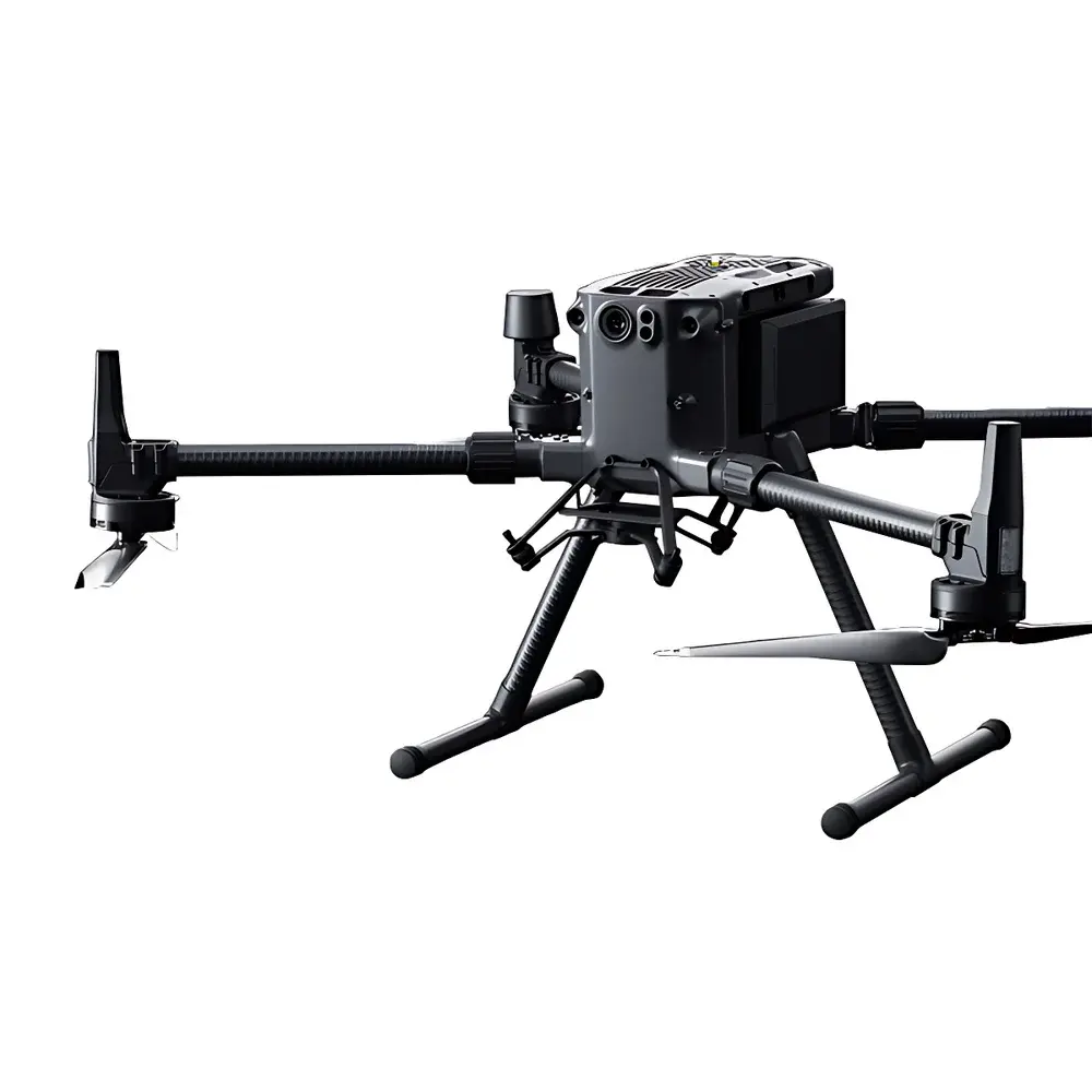
DJI Matrice 400 RTK Industrial Drone Platform
| Brand | DJI |
|---|---|
| Origin | Shenzhen, China |
| Manufacturer Type | Authorized Distributor |
| Country of Origin | China |
| Model | Matrice 400 RTK |
| Pricing | Available Upon Request |
| Max Payload Capacity | 6 kg |
| Max Takeoff Weight | 9.2 kg |
| Max Ascent Speed | 10 m/s |
| Max Horizontal Flight Speed | 25 m/s |
| Max Flight Time (Windless) | 59 min |
| Operating Frequency Bands | 2.400–2.4835 GHz, 5.150–5.250 GHz (CE: 5.170–5.250 GHz), 5.725–5.850 GHz |
| Compatible Gimbals | DJI H30, H30T, L2, P1 |
| Optional Payloads | Hyperspectral, Multispectral, Oblique Photogrammetry Cameras |
Overview
The DJI Matrice 400 RTK is a high-reliability, dual-IMU industrial drone platform engineered for mission-critical operations in regulated and demanding environments. Built upon a redundant flight control architecture with triple-redundant barometers and dual GNSS modules (GPS + GLONASS + BeiDou + Galileo), it delivers centimeter-level positioning accuracy via real-time kinematic (RTK) correction—enabling repeatable, georeferenced data acquisition without ground control points. Its aerodynamic airframe supports extended endurance (up to 59 minutes in windless conditions) and stable payload operation under dynamic wind loads, making it suitable for aerial surveying, infrastructure inspection, and time-sensitive emergency response deployments. Unlike consumer-grade platforms, the Matrice 400 RTK integrates industry-specific hardware interfaces—including CAN bus expansion ports, RS232/RS422 serial protocols, and a dedicated SDK port—for seamless integration with third-party sensors and mission-specific avionics.
Key Features
- Triple-redundant inertial measurement unit (IMU) and dual-barometer configuration for enhanced flight stability and fault tolerance
- Integrated Time-of-Flight (ToF) laser rangefinders and millimeter-wave radar for wire-level obstacle detection and avoidance—certified to IEC 61508 SIL2 functional safety requirements for proximity sensing
- O4 Enterprise Transmission System supporting dual-band, dual-antenna diversity with up to 20 km control range (FCC) and built-in airborne relay capability for line-of-sight extension over complex terrain
- Modular payload bay with standardized mechanical and electrical interfaces compliant with DJI Payload SDK v4.0 specifications
- IP45 ingress protection rating for operational resilience in light rain, dust, and temperature gradients from –20°C to 50°C
- Hot-swappable intelligent batteries with embedded telemetry and cycle-life monitoring compatible with DJI Battery Station management software
Sample Compatibility & Compliance
The Matrice 400 RTK is certified for use with DJI’s enterprise-grade gimbal payloads—including the H30 series (40× hybrid zoom, thermal + visible fusion), H30T (radiometric thermal imaging with ±2°C accuracy), L2 (dual-axis LiDAR + RGB mapping module), and P1 (full-frame 45 MP photogrammetry camera). It also supports third-party optical, multispectral, hyperspectral, and oblique camera systems via MavLink-compatible trigger interfaces and synchronized timecode output (PTPv2 IEEE 1588). Regulatory compliance includes CE RED Directive 2014/53/EU, FCC Part 15 Subpart C, IC RSS-247, and RoHS 2011/65/EU. For operational deployment in controlled airspace, the platform integrates with DJI FlightHub 2 cloud-based UTM services and supports ASTM F3322-21 remote ID implementation through firmware update.
Software & Data Management
DJI Pilot 2 mobile application provides intuitive mission planning, real-time telemetry visualization, and AR-assisted navigation—including live overlay of digital elevation models (DEMs), GIS vector layers, and preloaded KML boundaries. All flight logs, sensor metadata, and geotagged imagery are automatically synced to DJI Cloud with AES-256 encryption and configurable retention policies. For enterprise workflows, the platform supports direct export to industry-standard formats (GeoTIFF, LAS/LAZ, CSV, EXIF/XMP) and interoperability with photogrammetry engines such as Pix4Dmapper, Agisoft Metashape, and Bentley ContextCapture. Audit-ready data provenance is maintained via timestamped, signed flight records compliant with ISO 19115-1 metadata schema and optionally aligned with FDA 21 CFR Part 11 electronic record requirements when deployed in validated GxP environments.
Applications
The Matrice 400 RTK serves as a foundational aerial platform across multiple regulated verticals. In power transmission inspection, its millimeter-wave radar enables safe navigation within 3 meters of live conductors while capturing thermal anomalies with sub-pixel registration accuracy. For public safety applications—including fire suppression coordination and missing-person search—the system leverages real-time thermal analytics and onboard AI inference (via optional Jetson edge computing modules) to detect human heat signatures amid smoke or dense foliage. In civil engineering and cadastral surveying, integrated RTK-GNSS and L2 LiDAR enable direct georeferencing of point clouds with ≤3 cm horizontal and ≤5 cm vertical absolute accuracy (RMSE), satisfying ASPRS Positional Accuracy Standards for Class I surveys. Offshore maritime operations benefit from ship-deck takeoff/landing algorithms with motion compensation and dynamic GPS drift correction.
FAQ
Does the Matrice 400 RTK support third-party autopilot integration?
Yes—it features a standard MAVLink interface and supports PX4-based custom flight stacks via UART and CAN protocols, subject to firmware version compatibility and regulatory authorization.
What is the maximum allowable payload weight for certified thermal inspection missions?
The maximum certified payload remains 6 kg; however, thermal inspection configurations using the H30T must comply with DJI’s published center-of-gravity envelope and are subject to local aviation authority weight-class limitations (e.g., EASA UAS Class C2 certification thresholds).
Is firmware update logging traceable for quality assurance purposes?
All firmware updates are recorded in the aircraft’s internal event log with UTC timestamps, SHA-256 hash verification, and operator identification—exportable via DJI Assistant 2 for Enterprise and compatible with internal QMS audit trails.
Can the O4 transmission system be used in environments with high RF interference?
The O4 system employs adaptive frequency hopping, dynamic channel selection, and spatial diversity reception—validated in EMC testing per EN 301 489-1/-17—to maintain link integrity in industrial zones with dense 2.4 GHz and 5 GHz spectrum congestion.