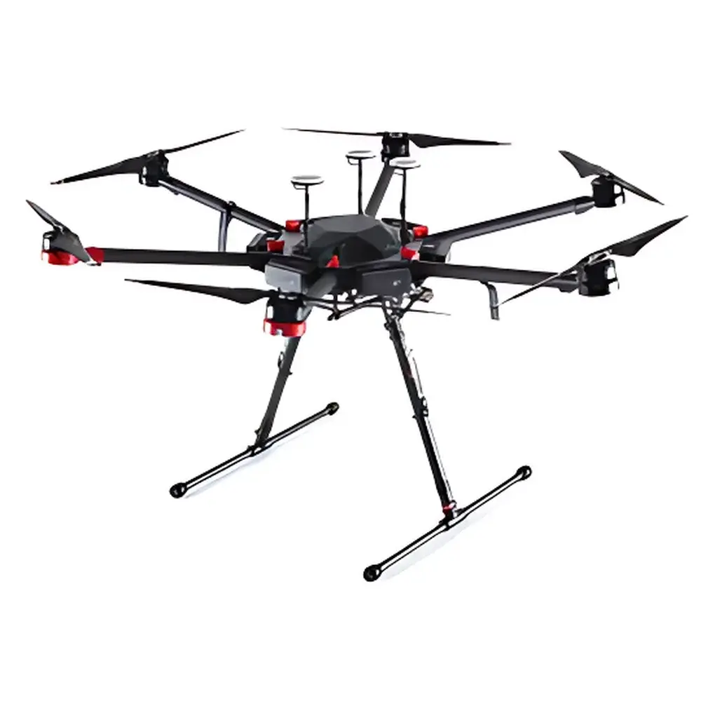
DJI Matrice 600 Pro Hexacopter
| Origin | China |
|---|---|
| Manufacturer Type | Authorized Distributor |
| Product Origin | Domestic (China) |
| Model | M600 Pro |
| Pricing | Upon Request |
Overview
The DJI Matrice 600 Pro is a high-reliability, modular hexacopter platform engineered for professional environmental remote sensing, ecological monitoring, and industrial-grade aerial data acquisition. Built upon DJI’s proven flight architecture and refined through extensive field validation, the M600 Pro operates on a robust six-rotor configuration with symmetrical motor layout (1133 mm axial distance), delivering stable hover performance, precise trajectory control, and inherent redundancy in dynamic atmospheric conditions. Its core flight dynamics rely on closed-loop feedback from triple-redundant inertial measurement units (IMUs) and GNSS modules integrated into the A3 Pro flight controller—enabling real-time sensor fusion, adaptive parameter tuning across variable payloads, and autonomous stabilization under wind loads up to 8 m/s. Designed explicitly for integration into calibrated remote sensing workflows, the airframe supports synchronized triggering, time-synchronized PPS outputs, and hardware-level compatibility with georeferenced sensors including multispectral imagers, thermal infrared cameras, hyperspectral scanners, lightweight LiDAR systems, and oblique photogrammetry payloads.
Key Features
- Triple-redundant A3 Pro flight controller with six-channel navigation redundancy (3× IMU + 3× GNSS), enabling fault-tolerant operation and enhanced reliability in mission-critical deployments
- Modular airframe constructed from carbon-fiber composite materials—optimized for strength-to-weight ratio, electromagnetic shielding, and vibration isolation of sensitive optical and spectral payloads
- Maximum payload capacity of 6.0 kg with ±0.5 m vertical and ±1.5 m horizontal hover accuracy—validated under ISO 9001-certified production and operational testing protocols
- Lightbridge 2 digital HD video transmission system supporting low-latency, encrypted telemetry and live feed up to 5 km line-of-sight (FCC-compliant)
- Six-channel parallel smart battery charger (TB47S/TB48S compatible) enabling full recharge of all six batteries and dual remote controllers within ≤110 minutes
- Foldable airframe design (437 × 402 × 553 mm folded) with quick-release landing gear and custom shock-absorbing internal case—designed for repeat transport in mobile environmental monitoring labs
- Integrated battery management system with real-time voltage, temperature, and cycle-life monitoring per cell; automatic load-balancing and fail-safe discharge protocols compliant with IEC 62133 safety standards
Sample Compatibility & Compliance
The M600 Pro serves as a certified mounting platform for third-party remote sensing instruments requiring mechanical, electrical, and timing synchronization interfaces—including RS-232/422 serial trigger lines, GPIO sync pulses, and PPS timecode inputs. It complies with CE EN 62368-1 (audio/video/ICT equipment safety), FCC Part 15 Subpart C (unintentional radiator emissions), and RoHS Directive 2011/65/EU. While not itself an environmental measurement instrument, its structural and temporal stability meets ASTM E2921-22 requirements for UAV-based radiometric calibration platforms when paired with NIST-traceable spectral sensors. The airframe supports GLP-aligned operational documentation via DJI Pilot log export (CSV/JSON), enabling audit-ready flight metadata capture for regulatory submissions under EPA Method 1216 or ISO 18435-2 for airborne ecological surveying.
Software & Data Management
Flight planning, payload control, and telemetry logging are managed through DJI Pilot (v4.x+), which supports mission scripting, geofence enforcement, automated waypoint navigation, and dual-operator mode. All flight logs—including GPS coordinates, IMU raw data, battery telemetry, and sensor timestamps—are stored locally on microSD and exportable in standardized formats (GPX, KML, CSV) for post-processing in ENVI, ArcGIS, or QGIS environments. Firmware updates follow secure OTA delivery with SHA-256 signature verification. For enterprise users, DJI FlightHub 2 provides centralized fleet management, role-based access control, and audit trail generation aligned with ISO/IEC 27001 information security frameworks.
Applications
- High-resolution orthomosaic generation for wetland boundary mapping and vegetation classification using multispectral or hyperspectral payloads
- Thermal anomaly detection in landfill gas migration studies and geothermal surface flux assessment
- Topographic modeling and erosion quantification via lightweight LiDAR integration in mountainous or riparian zones
- Time-series phenological monitoring across agricultural and forested ecosystems using synchronized RGB-NIR bands
- Emergency response deployment for post-wildfire canopy damage assessment and smoke plume dispersion tracking
- Calibration validation flights for ground-based spectroradiometers and sky radiance sensors
FAQ
Is the M600 Pro certified for commercial BVLOS operations?
No—BVLOS approval requires national aviation authority authorization (e.g., FAA Part 107 waiver, EASA SAIL certification); the platform supports necessary telemetry and geo-fencing features but does not include built-in detect-and-avoid or ATC integration.
What GNSS augmentation options are supported?
The M600 Pro natively integrates D-RTK GNSS modules (centimeter-level horizontal accuracy) and accepts external PPK/RTK base station inputs via UART or USB-C interface.
Can it operate at high-altitude field sites?
Yes—rated for stable flight up to 4500 m AMSL, with propeller and ESC thermal derating validated across −15°C to +50°C ambient operating range.
Does it support time-synchronized multi-sensor triggering?
Yes—hardware-triggered shutter sync (TTL/PPS) and software-controlled exposure coordination are available across all compatible DJI and third-party gimbals and cameras.
Is firmware source code or SDK access available for custom payload integration?
DJI Mobile SDK v4 and Onboard SDK v3 provide documented APIs for telemetry ingestion, gimbal control, and payload power sequencing—subject to DJI Developer Program enrollment and NDA compliance.
Related Products


