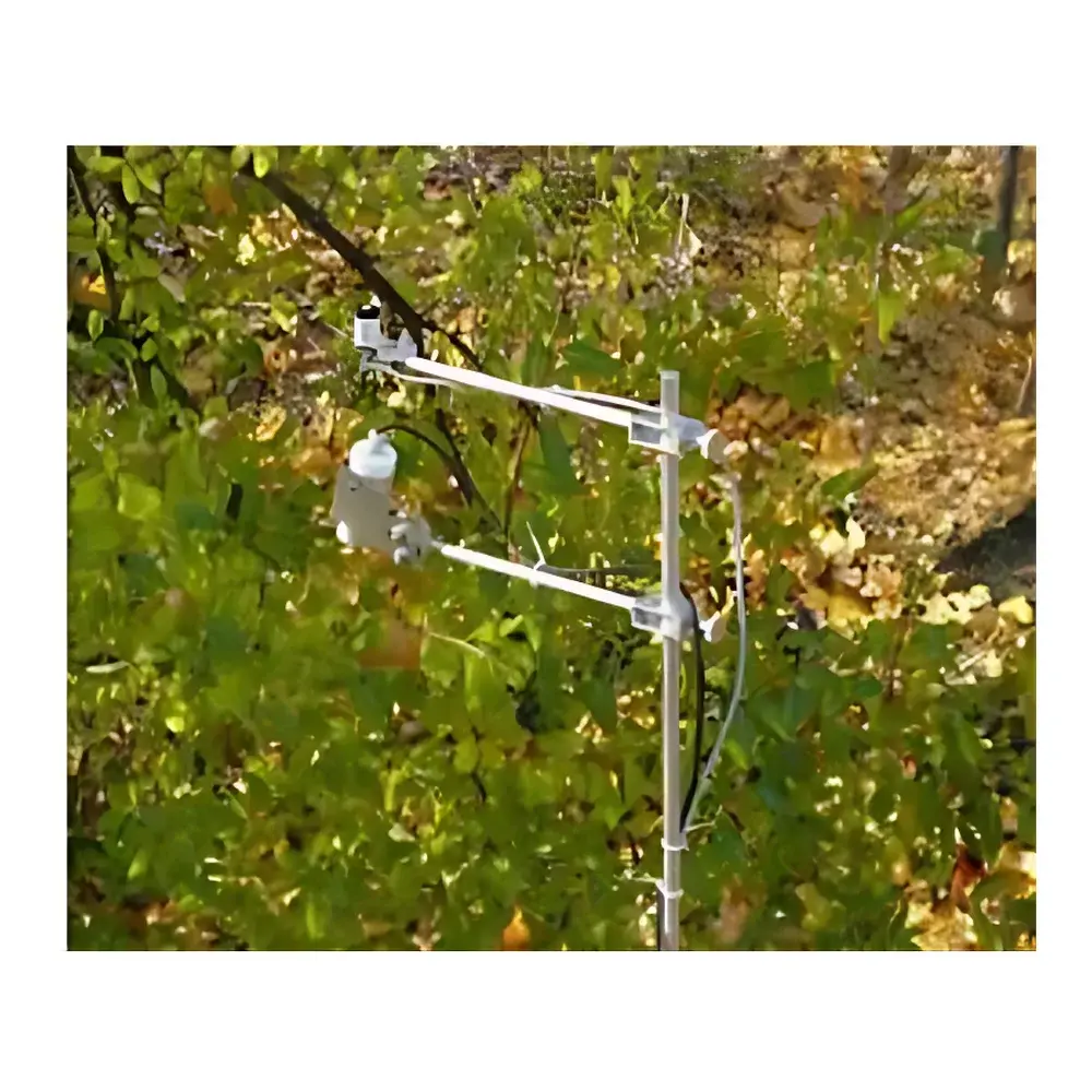
EMS-ET Field Spectral Online Observation System
| Brand | EMS |
|---|---|
| Origin | Czech Republic |
| Manufacturer Type | Authorized Distributor |
| Product Category | Imported Instrument |
| Model | EMS-ET |
| Pricing | Upon Request |
Overview
The EMS-ET Field Spectral Online Observation System is a robust, all-weather, autonomous platform engineered for continuous in situ spectral monitoring of plant canopies and leaves across natural and managed ecosystems. Operating on the physical principles of spectral reflectance, transmittance, and irradiance quantification, the system captures high-temporal-resolution radiometric data across ultraviolet (UV), visible (VIS), near-infrared (NIR), shortwave infrared (SWIR), and far-infrared (FIR) domains. By measuring bidirectional radiation fluxes—incident, reflected, and transmitted—the EMS-ET enables quantitative assessment of canopy optical properties directly linked to plant biochemical composition (e.g., chlorophyll, carotenoids, anthocyanins, water content, nitrogen, and carbon allocation), structural parameters (e.g., leaf area index, canopy closure, vertical stratification), and physiological status (e.g., photosynthetic efficiency, photoprotective capacity, stress-induced spectral shifts). Its design adheres to established radiometric measurement protocols aligned with ISO 17123-9 (optical remote sensing of vegetation) and supports traceable calibration practices compliant with NIST-traceable standards.
Key Features
- Multi-spectral sensor architecture supporting configurable band selection: UV-A (320–400 nm), UV-B (280–320 nm), PAR (400–700 nm), VIS (400–700 nm), NIR (700–1100 nm), SWIR (1100–2500 nm), and FIR (beyond 2500 nm), with optional total solar irradiance and UV index sensors.
- Dual-channel spectral sensors with 400–1050 nm spectral range, linear error <0.2%, cosine response error <5%, absolute calibration uncertainty ≤5%, and response time of 100 ns.
- Modular data acquisition unit with 16/32/64 analog input channels (user-selectable), up to 107 SDI-12 digital sensor channels, 8 pulse-counting inputs, and 16–32 RTD inputs; measurement accuracy ±0.03% of reading.
- Onboard data storage capacity of 220,000 timestamped records (expandable to 450,000); sampling interval programmable from 3 seconds to 4 hours.
- Integrated GSM/GPRS and Ethernet/IP connectivity for real-time remote data transmission; low-power operation (standby current 5 years service life.
- Field-deployable mechanical design optimized for canopy-level deployment: standard mounting height 1.8 m yields ~0.5 m² field-of-view; modular sensor positioning for upper/mid/lower canopy layer transmittance profiling.
Sample Compatibility & Compliance
The EMS-ET is validated for long-term deployment across diverse vegetation types—including grasslands, agroforestry systems, temperate and tropical forests, crop canopies, and alpine tundra—under variable climatic conditions. Sensor geometry and cosine correction ensure compliance with ASTM E2913-13 (Standard Practice for Determining Spectral Reflectance of Vegetation Canopies) and support GLP-aligned field data collection workflows. All firmware and software modules are compatible with FDA 21 CFR Part 11 requirements for electronic records and signatures when deployed in regulated agricultural research or environmental monitoring contexts. System metadata—including sensor calibration certificates, installation logs, and environmental context tags—are embedded in exported datasets to facilitate reproducibility and audit readiness.
Software & Data Management
The EMS-ET includes a dedicated web-based data server and analytical suite supporting secure HTTPS access, role-based user permissions, and automated daily data synchronization via 4G LTE. Raw spectral data are stored in NetCDF-4 format with CF-1.8 metadata conventions, ensuring interoperability with NASA’s LP DAAC, ESA’s Copernicus Open Access Hub, and FAO’s WaPOR database infrastructure. The embedded analysis engine computes standardized vegetation indices—including NDVI, PRI, RVI, EVI, SAVI, GNDVI, and MSAVI2—with user-definable band math and batch processing capabilities. Time-series analytics include spectral trajectory modeling, phenological break-point detection, and multivariate regression for canopy biophysical parameter inversion (e.g., LAI, fPAR, canopy water content). All operations generate immutable audit trails with timestamps, operator IDs, and version-controlled processing scripts.
Applications
- Phenotyping trials: High-throughput quantification of spectral responses to drought, nutrient deficiency, pathogen infection, or elevated CO₂ across genotype panels.
- Ecosystem monitoring: Long-term tracking of seasonal spectral dynamics in montane cloud forests (e.g., HERB project), peatlands, and semi-arid rangelands.
- Crop management optimization: Real-time feedback for precision irrigation and nitrogen application based on PRI and NDVI temporal derivatives.
- Satellite validation: Ground-truth spectral libraries for atmospheric correction and algorithm training of Sentinel-2, Landsat 9, and PRISMA missions.
- Controlled environment studies: Integration with climate chambers (e.g., IGER facility) for spectral dose–response modeling under manipulated light quality and intensity regimes.
- Urban green infrastructure assessment: Quantifying spectral signatures of street trees and green roofs for thermal regulation and carbon sequestration modeling.
FAQ
What spectral resolution and sampling rate does the EMS-ET support?
The system acquires full-range spectra at user-defined intervals—from 1 Hz (1 spectrum per second) to hourly averages—with discrete band sensors offering fixed-width passbands (e.g., 400–480 nm, 760–850 nm) and custom narrowband options available upon request.
Can the EMS-ET be integrated with existing weather stations or IoT platforms?
Yes. The data logger supports Modbus RTU/TCP, SDI-12, and analog voltage/current outputs, enabling seamless integration with Campbell Scientific, Decagon, Vaisala, and third-party SCADA or edge-computing gateways.
Is factory recalibration required, and how often?
Annual recalibration against NIST-traceable reference standards is recommended; each sensor ships with a certificate of calibration valid for 12 months under normal field use conditions.
Does the system support autonomous operation during extended power outages?
Yes. The dual-power architecture combines primary DC input (6.5–15 VDC) with a field-replaceable 3 V lithium thionyl chloride backup battery rated for continuous operation over 5 years in standby mode.
Are spectral data export formats compatible with ENVI, QGIS, and Python-based analysis pipelines?
All datasets are delivered in CF-compliant NetCDF-4 files with embedded geospatial metadata, fully ingestible by GDAL, xarray, rasterio, and commercial GIS platforms without conversion.