Envidata Soil Moisture and Drought Monitoring Management System
| Origin | Germany |
|---|---|
| Manufacturer Type | Distributor |
| Origin Category | Imported |
| Model | Envidata |
| Pricing | Upon Request |
Overview
The Envidata Soil Moisture and Drought Monitoring Management System is a field-deployable, Internet-connected environmental monitoring platform engineered for continuous, in-situ measurement and integrated analysis of soil water status, crop physiological parameters, and microclimatic variables. Built upon Time Domain Reflectometry (TDR) sensor technology—operating at 1 GHz electromagnetic pulse frequency—the system delivers high-fidelity volumetric water content (θv) measurements with sub-3 ps temporal resolution, enabling precise quantification of soil moisture dynamics across heterogeneous agricultural landscapes. Its architecture supports real-time telemetry via Ethernet, GPRS, or satellite communication, feeding time-synchronized data streams into a centralized relational database. Designed to meet the stringent operational reliability requirements of national hydrological monitoring networks—including those mandated by China’s Ministry of Water Resources—the system complies with ISO 9001:2008 quality management standards and has been formally listed in the “2013 Key Promotional Guidance Catalogue of Advanced Practical Water Conservancy Technologies” issued by the China Water Resources Science and Technology Promotion Center.
Key Features
- Field-proven TDR-based soil moisture sensors (TRIME-PICO-64/32) with volumetric water content range 0–100%, ±1–2% accuracy (dependent on soil texture and calibration), and IP68-rated probe housings for long-term burial stability.
- Data logger featuring dual-channel isolation, 15 analog inputs (expandable to 300), 12 configurable digital I/O channels, 128 MB internal memory (supporting >10 million data points), and USB 2.0/RS232/Ethernet connectivity.
- Modbus RTU and SDI-12 protocol support for interoperability with third-party SCADA systems and legacy environmental sensors.
- FTP-based automated data push architecture—eliminating reliance on PSTN modems—ensuring higher transmission reliability, lower operational cost, and reduced maintenance overhead compared to legacy telephony-based telemetry.
- Multi-parameter acquisition capability: soil θv, temperature, electrical conductivity (EC), CO2; plant canopy temperature, stem diameter variation, sap flow; meteorological variables including precipitation, air temperature/humidity, wind speed/direction, PAR, net radiation, and atmospheric pressure.
- Configurable alarm logic with email/SMS notification triggers based on user-defined thresholds (e.g., θv falling below refill point, EC exceeding salinity tolerance limits).
Sample Compatibility & Compliance
The Envidata system accommodates diverse soil textures—from sandy loam to heavy clay—through customizable calibration curves (up to 15 user-defined profiles stored onboard). Sensor probes are validated per ASTM D5778 (Standard Test Method for Determining the In-Situ Electrical Resistivity of Soil Using the Wenner Four-Electrode Method) and ISO 11274 (Soil Quality – Determination of Water Retention Characteristic). Data integrity protocols align with GLP principles, supporting audit trails for timestamped measurements, firmware updates, and configuration changes. The software platform meets functional requirements for regulatory reporting under China’s Hydrological Information and Forecasting Standard (SL 460–2009) and is compatible with national drought early-warning frameworks requiring spatially distributed, near-real-time soil moisture indices.
Software & Data Management
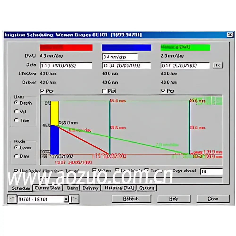
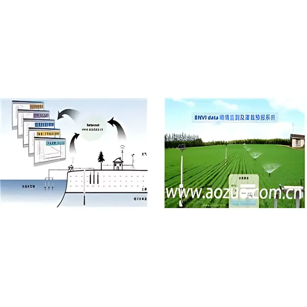
The ENVIdata Server Software operates as a client-server application deployable on-premises or hosted on secure cloud infrastructure (e.g., Auso-operated servers). It ingests asynchronous sensor data from up to 1,000 remote stations, stores metadata in a normalized PostgreSQL schema, and provides role-based web access via HTTPS. Core modules include: (1) Real-time dashboard with georeferenced station mapping; (2) Time-series visualization (hourly/daily/seasonal θv trends); (3) Depth-profile plotting for root-zone moisture distribution analysis; (4) Irrigation scheduling engine incorporating FAO-56 Penman-Monteith evapotranspiration estimates, crop coefficient (Kc) staging, soil hydraulic properties, and forecasted precipitation; (5) Export functionality generating CSV/Excel reports compliant with national water resource statistical reporting formats. All user actions—including data edits, alarm acknowledgments, and report generation—are logged with timestamps and operator IDs to satisfy 21 CFR Part 11 traceability requirements where applicable.
Applications
- Regional-scale irrigation advisory services: Generating site-specific irrigation timing and depth recommendations for cotton (Xinjiang Production and Construction Corps), wine grapes (California), sugarcane (Switzerland), apples (South Africa), and vegetable production (Kenya).
- Research on root-zone water uptake patterns: Deployed since 2008 at China Institute of Water Resources and Hydropower Research (IWHR) Beijing Daxing Experimental Base for long-term validation of coupled soil-plant-atmosphere models.
- Drought impact assessment: Supporting provincial water bureaus in quantifying soil moisture deficits relative to historical percentiles and triggering tiered emergency response protocols.
- Salinity and nutrient leaching studies: Correlating vertical θv and EC profiles to identify preferential flow paths and evaluate subsurface drainage efficacy.
- Climate-smart agriculture initiatives: Integrating NDVI, canopy temperature, and soil moisture time series to calibrate crop water stress indices (CWSI) and optimize deficit irrigation strategies.
FAQ
What communication protocols does the data logger support?
The logger natively supports Modbus RTU, SDI-12, and FTP for data transmission. Optional RS232, USB, and Ethernet interfaces enable integration with SCADA systems or local network infrastructure.
Can the system operate without continuous Internet connectivity?
Yes—onboard 128 MB memory ensures uninterrupted logging during network outages. Data syncs automatically once connectivity resumes, preserving temporal continuity.
How many sensors can be connected to a single station?
Standard configuration includes 2–6 analog input channels, expandable to 300 via modular analog expansion units. Up to 10 SDI-12 sensors may be daisy-chained per port.
Is soil-specific calibration required?
While factory calibration covers common mineral soils, optimal accuracy for organic-rich or saline soils requires empirical calibration using gravimetric sampling. The system stores up to 15 custom calibration curves.
Does the software support multi-user access with permission levels?
Yes—role-based authentication allows administrators to assign read-only, editing, or system-admin privileges to individual users or groups.
What is the operating temperature range for field hardware?
Data loggers function from –45°C to +70°C; TRIME-PICO probes operate from –15°C to +50°C (extended ranges available upon request).
Related Products


