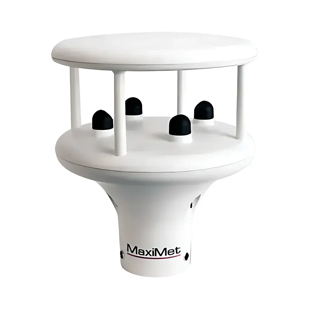
Gill GMX260 Ultrasonic Anemometer
| Brand | Gill |
|---|---|
| Origin | United Kingdom |
| Model | GMX260 |
| Instrument Type | Ultrasonic Anemometer |
| Resolution | 0.01 m/s |
| Measurement Range | 0–60 m/s |
| Accuracy | ±0.3 m/s (RMSE: 0.3 m/s at 0–10 m/s |
| Operating Temperature | −35 to +70 °C |
| Operating Humidity | 0–100 % RH |
| Wind Direction Range | 0–360° |
| Wind Direction Accuracy | ±3° (0.5–40 m/s), ±5° (40–60 m/s) |
| Wind Direction Resolution | 1° |
| Output Protocols | RS232, RS422, RS485, SDI-12 v1.3, NMEA 0183, MODBUS (RTU & ASCII), ASCII |
| Output Frequency | 1 Hz, 1 min, 1 hour, or polled |
| Power Supply | 5–30 VDC |
| Power Consumption | 28 mA (nominal, 12 VDC, continuous, standard) |
| Enclosure Rating | IP66 & IP68 |
| Housing Material | UV-stabilized thermoplastic |
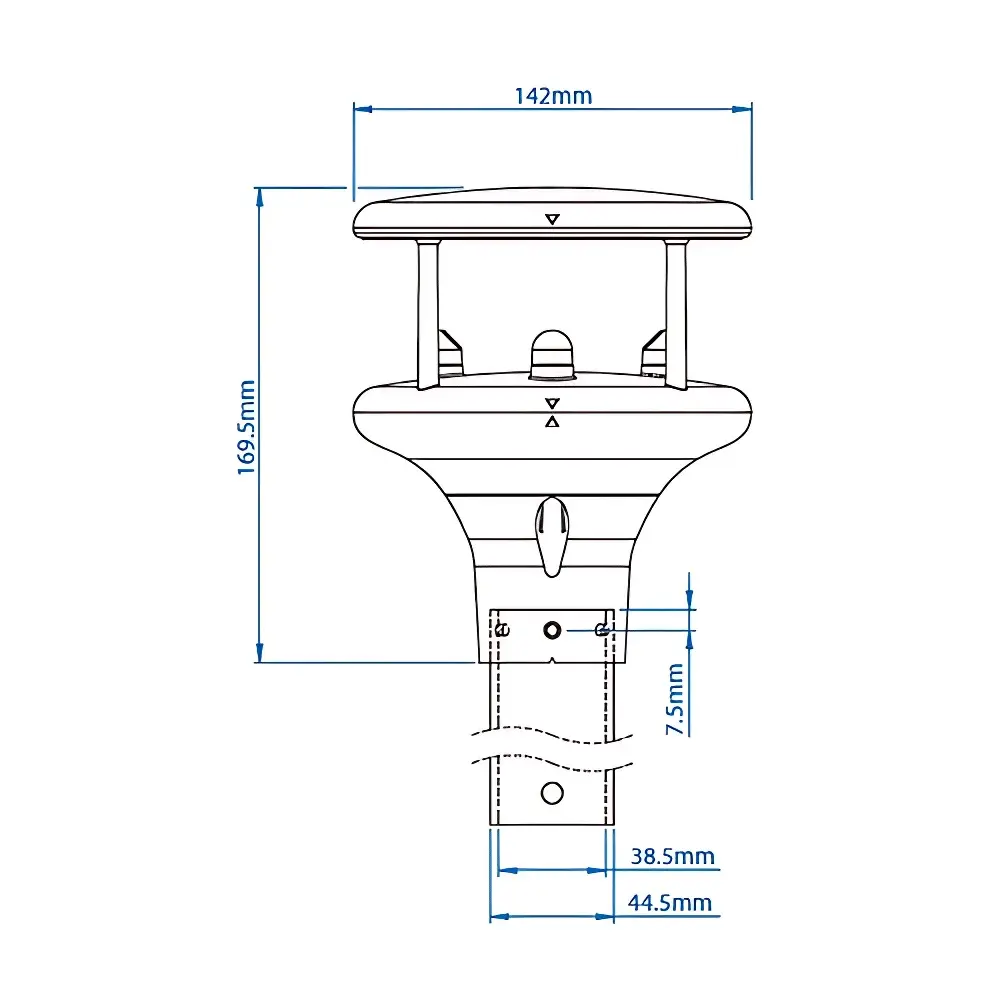
| Mounting | Compatible with 44.45 mm (1.75 in) mast/tube |
| Weight | 0.5 kg |
| Optional | Integrated GPS (provides position, altitude, UTC timestamp, and true wind vector correction for moving platforms) |
Overview
The Gill GMX260 Ultrasonic Anemometer is a high-reliability, compact, solid-state wind sensor engineered for continuous, maintenance-free operation in demanding environmental and marine applications. Utilizing time-of-flight ultrasonic transit-time measurement across three orthogonal acoustic paths, the GMX260 determines horizontal wind speed and direction without mechanical moving parts—eliminating bearing wear, icing susceptibility, and calibration drift associated with cup-and-vane anemometers. Its design inherits core metrological architecture from Gill’s scientific-grade instrumentation portfolio, ensuring traceable accuracy, long-term stability, and robust performance under extreme thermal cycling, salt-laden atmospheres, and transient submersion events. The device complies with World Meteorological Organization (WMO) guidelines for gust detection (3-second maximum over 10-minute averaging interval) and supports derivation of secondary meteorological parameters—including 10-minute mean wind vector, peak gust magnitude and timing, and corrected wind direction accounting for platform tilt.
Key Features
- Solid-state ultrasonic transducer array with no rotating components—enabling >10-year field service life and zero routine mechanical maintenance
- Dual IP66 and IP68 ingress protection ratings—certified for continuous outdoor exposure and temporary immersion up to 1.5 m for 30 minutes
- Integrated 6-axis electronic compass providing real-time pitch and roll compensation, essential for accurate wind vector correction on floating or mobile platforms
- Low-power architecture optimized for solar- and battery-powered deployments: 1.3 mA quiescent current in hourly reporting mode
- Multi-protocol digital output supporting RS232/RS422/RS485 serial interfaces, SDI-12 v1.3, NMEA 0183, and MODBUS RTU/ASCII—facilitating seamless integration into SCADA, IoT telemetry gateways, and legacy data loggers
- Optional integrated GPS module delivering georeferenced UTC timestamps, ellipsoidal height, and true wind vector calculation via motion-compensated navigation solution (critical for UAVs, USVs, and offshore vessels)
Sample Compatibility & Compliance
The GMX260 is validated for deployment across heterogeneous environmental regimes—from Arctic coastal stations (−35 °C operational limit) to tropical maritime zones (100 % RH, non-condensing). Its UV-stabilized thermoplastic housing resists degradation from prolonged solar irradiance and chemical exposure in industrial port environments. Electrical interfaces conform to IEC 61000-6-2 (immunity) and IEC 61000-6-4 (emissions) standards. Firmware implements configurable data validation flags and self-diagnostic status reporting per IEC 61508 SIL 2 functional safety principles. While not certified to FDA 21 CFR Part 11, its ASCII and MODBUS outputs support audit-trail-capable data acquisition systems compliant with GLP and ISO/IEC 17025 laboratory quality frameworks.
Software & Data Management
Data output is structured as ASCII-formatted strings—each containing synchronized wind speed, wind direction, gust magnitude, timestamp, and diagnostic flags. Users may configure output frequency (1 Hz to 1/hour) and protocol framing independently per interface. The optional GPS-enabled variant appends WGS84 coordinates, MSL altitude, and Doppler-derived ground speed to enable true wind computation using platform motion vectors. All configurations are managed via terminal command set or embedded web interface (when used with compatible Gill communication hubs). Raw data streams integrate natively with industry-standard platforms including Campbell Scientific LoggerNet, CRBasic, and third-party MQTT brokers for cloud ingestion. No proprietary software license is required for basic configuration or data parsing.
Applications
- Oceanographic buoys and autonomous surface vehicles (ASVs) requiring corrosion-resistant, low-power wind profiling with motion compensation
- Offshore wind farm monitoring—mounted on turbine nacelles or met masts to support power curve validation and wake characterization
- Helideck wind shear detection systems meeting CAP 437 and ICAO Annex 14 compliance requirements
- Port and harbor meteorological networks integrating with VTS (Vessel Traffic Services) for real-time navigational safety alerts
- Remote environmental observatories powered by photovoltaic arrays where energy budget constraints preclude high-duty-cycle sensors
- Urban air quality monitoring networks requiring spatially distributed, low-maintenance wind inputs for dispersion modeling
FAQ
Does the GMX260 require periodic recalibration?
No scheduled recalibration is specified by Gill. The ultrasonic measurement principle is inherently stable; field verification against reference standards (e.g., NIST-traceable pitot tube) is recommended every 24 months for metrological assurance in regulatory contexts.
Can the GMX260 operate underwater?
It is rated IP68 for temporary immersion (≤1.5 m for ≤30 minutes), but continuous submersion is not supported. Acoustic propagation in water invalidates wind measurement functionality.
Is the GPS option mandatory for true wind calculation?
Yes—true wind vector derivation requires simultaneous knowledge of platform heading, speed over ground, and attitude; only the GPS-enabled variant provides all necessary motion parameters.
What mounting hardware is included?
The unit ships with a universal U-bolt clamp compatible with 44.45 mm (1.75 in) diameter masts. Custom mounting brackets and marine-grade stainless fasteners are available as accessories.
How does the 6-axis compass improve wind direction accuracy?
It measures real-time pitch and roll angles, allowing firmware to rotate the measured wind vector into Earth-fixed coordinates—reducing directional error caused by mast flexure or platform tilt, especially critical on floating structures.