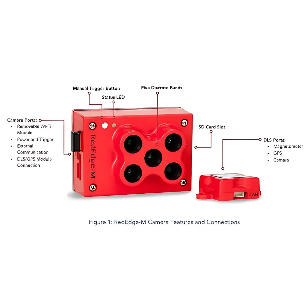

MicaSense RedEdge-MX 5-Band Multispectral Imaging Sensor
| Brand | MicaSense |
|---|---|
| Origin | USA |
| Manufacturer | MicaSense, Inc. |
| Model | RedEdge-MX |
| Spectral Bands | Blue (475 nm, 20 nm FWHM), Green (560 nm, 20 nm FWHM), Red (668 nm, 10 nm FWHM), Red Edge (717 nm, 10 nm FWHM), Near-Infrared (840 nm, 40 nm FWHM) |
| Weight | 170 g (incl. DLS) |
| Dimensions | 9.4 × 6.3 × 4.6 cm |
| Operating Voltage | 4.2–15.8 V DC |
| Power Consumption | 4 W (typ.), 8 W (max.) |
| Ground Sampling Distance (GSD) | 8.2 cm/pixel at 120 m AGL |
| Capture Rate | 1 frame/sec |
| Output Format | 12-bit RAW per band + geotagged JPEG |
| Interface Options | Wi-Fi, Ethernet, UART |
| Environmental Rating | No moving parts |
| Calibration | Factory radiometric and geometric calibration |
| Software Ecosystem | Atlas cloud platform + desktop tools (AgPixel, Pix4D, QGIS, ENVI plugins) |
Overview
The MicaSense RedEdge-MX is a precision-engineered, UAV-integrated 5-band multispectral imaging sensor designed for high-fidelity ecological remote sensing and agricultural monitoring. Operating on the principle of discrete-band spectral reflectance measurement, it captures synchronized, co-registered imagery across five narrowband spectral channels—Blue, Green, Red, Red Edge, and Near-Infrared—each with factory-traceable radiometric calibration. Unlike broadband or RGB-only sensors, the RedEdge-MX delivers spectrally resolved data essential for computing biophysically meaningful vegetation indices (VIs) with proven sensitivity to plant pigment concentration, canopy structure, and physiological stress. Its optical architecture employs individual global-shutter CMOS imagers paired with interference-grade bandpass filters, ensuring minimal crosstalk and high spectral fidelity. The system’s compact form factor (9.4 × 6.3 × 4.6 cm), low mass (170 g including integrated Downwelling Light Sensor), and wide input voltage range (4.2–15.8 V DC) enable seamless integration onto small to medium-class UAV platforms without compromising flight endurance or stability.
Key Features
- Simultaneous acquisition of five spectrally distinct bands with precise center wavelengths and narrow full-width half-maximum (FWHM) bandwidths—475 nm (20 nm), 560 nm (20 nm), 668 nm (10 nm), 717 nm (10 nm), and 840 nm (40 nm)—optimized for chlorophyll absorption, red edge inflection, and NIR reflectance dynamics.
- Integrated Downwelling Light Sensor (DLS) enabling real-time illumination normalization, critical for cross-flight and diurnal consistency in reflectance-derived indices.
- Global shutter design with circular aperture eliminates motion-induced distortion (e.g., rolling shutter skew) across fixed-wing, multirotor, and VTOL platforms.
- Onboard geotagging: Each image embeds GPS position, altitude, IMU orientation, and UTC timestamp—no post-processing alignment with flight logs or third-party georeferencing tools required.
- Ruggedized, solid-state construction with zero moving parts ensures operational reliability under vibration, thermal cycling, and humidity exposure typical of field-deployed UAV missions.
- Flexible connectivity: Configurable via Wi-Fi web interface (browser-based), Ethernet, or UART for direct telemetry integration with autopilot systems (e.g., PX4, ArduPilot) and real-time status feedback.
- 12-bit RAW output per band preserved on standard microSD card, supporting scientific-grade post-processing workflows compliant with FAIR (Findable, Accessible, Interoperable, Reusable) data principles.
Sample Compatibility & Compliance
The RedEdge-MX is validated for use in open-field agricultural ecosystems, managed forests, wetland monitoring zones, and precision viticulture applications. Its spectral response aligns with widely adopted remote sensing standards—including USDA-NRCS crop health protocols, ESA Sentinel-2 band equivalency (B03/B04/B05/B06/B08), and ISO 11727:2021 (optical methods for vegetation parameter estimation). While not certified for regulatory submission per se, its radiometric calibration traceability (NIST-traceable reference sources used during production) supports GLP-aligned data collection practices. Data outputs are compatible with USDA-ARS field trial reporting templates and meet minimum requirements for peer-reviewed publication in journals such as Remote Sensing of Environment and ISPRS Journal of Photogrammetry and Remote Sensing.
Software & Data Management
Data acquisition, orthomosaic generation, and index computation are supported through MicaSense Atlas—a secure, browser-based cloud platform offering automated radiometric correction, reflectance conversion, and VI mapping (NDVI, NDRE, CIrededge, GNDVI, OSAVI). Atlas exports GeoTIFFs with embedded projection metadata (EPSG:4326 or UTM), enabling direct ingestion into GIS environments (QGIS, ArcGIS Pro) and statistical analysis suites (R, Python with rasterio/scikit-image). Local processing is supported via open-format SDKs and documented APIs. All raw datasets retain EXIF and XMP sidecar metadata conforming to ISO 19115-2 and FGDC CSDGM standards. Audit trails—including sensor temperature logs, DLS irradiance records, and firmware version stamps—are retained for reproducibility verification in longitudinal studies.
Applications
- Agricultural Stress Detection: Early identification of nitrogen deficiency via Chlorophyll Index (CIrededge) and nitrogen-responsive VIs, enabling variable-rate fertilization planning.
- Canopy Architecture Assessment: Estimation of leaf area index (LAI) and fractional cover using red-edge/NIR ratio models validated against ground-truthed LAI-2200 measurements.
- Disease & Pest Monitoring: Discrimination of fungal infection (e.g., Septoria tritici blotch in wheat) through anomalous red-edge slope shifts prior to visible symptom onset.
- Vineyard Zoning: Spatial delineation of vigor classes using NDVI and NDRE composites to inform harvest scheduling and irrigation management.
- Wetland Hydrology Mapping: Differentiation of emergent vs. submerged vegetation using NIR/Red Edge contrast, supporting EPA Level III wetland classification workflows.
- Post-Fire Regeneration Tracking: Time-series analysis of normalized burn ratio (NBR) and differenced NBR (dNBR) derived from calibrated RedEdge-MX stacks.
FAQ
Does the RedEdge-MX require an external calibration target during operation?
No. Each unit undergoes factory radiometric calibration using NIST-traceable sources and includes an integrated Downwelling Light Sensor (DLS) for scene-referenced normalization. No pre-flight or in-field integrating sphere is necessary.
Can the RedEdge-MX be triggered externally by an autopilot system?
Yes. It supports hardware trigger input (TTL pulse) and serial command protocols (MAVLink-compatible UART) for synchronized capture with GPS position logging and flight control events.
What coordinate reference system (CRS) is used for geotagged imagery?
All images embed WGS84 (EPSG:4326) coordinates by default. Orthorectified outputs from Atlas or third-party photogrammetry software preserve user-specified CRS, including UTM zone definitions.
Is raw data accessible for custom algorithm development?
Yes. 12-bit per-pixel RAW files (DNG format) are stored unprocessed on microSD card, accompanied by comprehensive metadata (exposure, gain, sensor temperature, DLS irradiance) in JSON sidecar files.
How does the RedEdge-MX handle varying solar illumination across a flight mission?
The integrated DLS continuously measures incident irradiance spectra, allowing pixel-level reflectance normalization independent of time-of-day, cloud cover, or aircraft attitude—ensuring quantitative comparability across multi-temporal datasets.