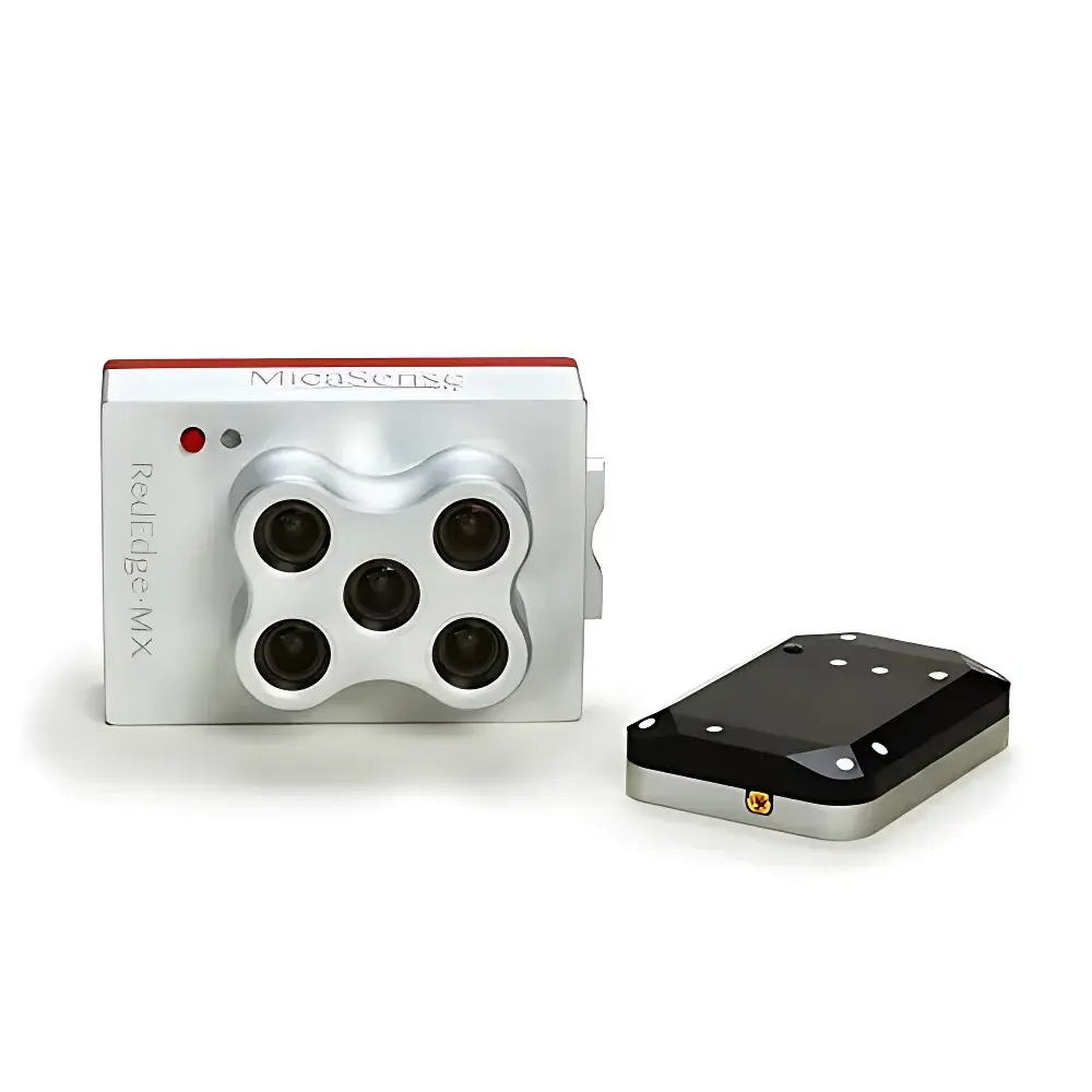
MicaSense RedEdge-MX 5-Channel Multispectral Camera
| Brand | MicaSense |
|---|---|
| Model | RedEdge-MX |
| Sensor Channels | 5 (Blue, Green, Red, Red Edge, Near-Infrared) |
| Spectral Bands | Blue (475 nm ±10 nm), Green (560 nm ±10 nm), Red (668 nm ±5 nm), Red Edge (717 nm ±5 nm), NIR (840 nm ±20 nm) |
| Spatial Resolution | 8 cm GSD at 120 m AGL |
| Sensor Format | Global Shutter CMOS, 1280 × 960 px per band |
| FOV | 47.2° HFOV |
| Weight | 232 g |
| Dimensions | 8.7 × 5.9 × 4.54 cm |
| Power Input | 4.2–15.8 V DC |
| Power Consumption | 4 W (idle), 8 W (peak) |
| Interface | Gigabit Ethernet, Serial (UART), Wi-Fi (802.11 b/g/n), GPS, External Trigger, SDHC Slot (up to 32 GB) |
| Capture Rate | 1 Hz |
| Integrated DLS2 | Dual-sensor irradiance + solar angle measurement |
| Radiometric Calibration | Factory-calibrated, vignetting & spectral crosstalk corrected |
| Compliance | CE, FCC, RoHS |
Overview
The MicaSense RedEdge-MX is a professional-grade, five-band multispectral imaging system engineered specifically for precision agriculture and environmental remote sensing applications. Unlike conventional RGB or single-band sensors, the RedEdge-MX employs synchronized global shutter CMOS detectors across five discrete, narrowband spectral channels—covering blue (475 nm), green (560 nm), red (668 nm), red edge (717 nm), and near-infrared (840 nm)—to capture radiometrically calibrated reflectance data in a single exposure. Its optical architecture follows the principles of pushbroom-free, frame-based multispectral acquisition, enabling pixel-aligned band registration without motion-induced parallax or geometric distortion. The integrated DLS2 (Downwelling Light Sensor二代) module co-locates irradiance sensing and real-time solar geometry computation within the camera housing, eliminating external calibration dependencies and significantly improving absolute radiometric accuracy under variable illumination conditions. Designed for direct integration with UAV platforms—including both multirotor and fixed-wing systems—the RedEdge-MX operates within a wide input voltage range (4.2–15.8 V DC), consumes minimal power (≤8 W peak), and maintains consistent thermal stability during extended flight operations.
Key Features
- Five spectrally optimized bands: Independently filtered channels with full-width half-maximum (FWHM) bandwidths ranging from 10 nm (red, red edge) to 40 nm (NIR), ensuring high spectral fidelity for vegetation index derivation.
- Global shutter synchronization: All five bands expose simultaneously, preventing motion blur and enabling precise pixel-to-pixel alignment—critical for generating orthomosaics and time-series change detection.
- DLS2 integrated irradiance sensor: Combines cosine-corrected photodiode array with inertial measurement unit (IMU) to record incident solar irradiance and solar zenith/azimuth angles at acquisition time, supporting physics-based atmospheric correction.
- Radiometric calibration traceability: Each unit undergoes factory calibration against NIST-traceable standards; includes per-pixel vignetting, spectral crosstalk, and temperature-dependent gain compensation models embedded in metadata.
- Onboard processing & connectivity: Embedded Linux OS supports direct Wi-Fi access via browser-based interface; configurable capture modes (time-lapse, distance-based, external trigger); real-time preview and status telemetry over Ethernet or UART.
- Compact, ruggedized design: IP64-rated enclosure; operating temperature range −10 °C to 50 °C; compliant with UAV vibration and shock specifications per MIL-STD-810G.
Sample Compatibility & Compliance
The RedEdge-MX is designed for aerial deployment over heterogeneous land surfaces, including row crops (corn, soybean, cotton), orchards, vineyards, pasturelands, and forested areas. It does not require ground control points for relative reflectance analysis but supports integration with RTK-GNSS receivers for georeferenced DSM/DTM generation. Data outputs conform to standard GeoTIFF and TIFF+XML formats compliant with OGC Best Practices for Remote Sensing Metadata (ISO 19115-3). Radiometric processing workflows align with ASTM E2527 (Standard Practice for Calculating Vegetation Indices) and support validation against USDA ARS field protocols. The device meets electromagnetic compatibility requirements per EN 61000-6-3 (Emission) and EN 61000-6-2 (Immunity), and carries CE, FCC Part 15 Subpart B, and RoHS certifications. While not intended for regulated clinical or pharmaceutical use, its data integrity features—including embedded timestamping, sensor health logging, and non-volatile configuration storage—support GLP-aligned documentation practices in agronomic research settings.
Software & Data Management
Data acquisition and preprocessing are supported by MicaSense’s proprietary Atlas cloud platform and open-source AgriFlight desktop application (Windows/macOS/Linux). Atlas provides automated orthomosaic stitching, radiometric normalization using DLS2-derived irradiance, and batch computation of 20+ vegetation indices—including NDVI, NDRE, CIrededge, SAVI, and Chlorophyll Index—using scientifically validated algorithms. All raw images retain EXIF and XMP metadata containing GPS coordinates, IMU orientation, DLS2 irradiance values, exposure parameters, and sensor temperature—enabling reproducible reprocessing. Export options include GeoTIFF layers, CSV reports, KML overlays, and RESTful API access for integration into enterprise GIS (ArcGIS, QGIS) or farm management software (Granular, Climate FieldView, FarmLogs). Audit trails, user role permissions, and encrypted data transmission comply with ISO/IEC 27001 information security guidelines.
Applications
- Precision crop monitoring: Quantify chlorophyll content, nitrogen status, and water stress through red-edge and NIR band ratios; detect early-stage biotic/abiotic stress before visible symptom onset.
- Yield prediction modeling: Correlate canopy density metrics (e.g., LAI derived from NDVI time series) with historical yield maps to train machine learning regression models.
- Irrigation optimization: Generate evapotranspiration (ET) proxy maps using thermal-inertial fusion (when paired with compatible thermal sensors) or water band indices (e.g., NDWI).
- Regulatory compliance reporting: Support EU CAP (Common Agricultural Policy) greening requirements and U.S. NRCS conservation practice documentation via standardized biomass and cover fraction estimates.
- Ecosystem assessment: Monitor post-fire regeneration, invasive species encroachment, or wetland delineation using multi-temporal spectral unmixing techniques.
FAQ
Does the RedEdge-MX require external calibration targets during flight?
No. The integrated DLS2 sensor enables absolute radiometric calibration without reflectance panels, though panel-based cross-validation is recommended for mission-critical scientific studies.
Can the RedEdge-MX be triggered externally via PWM or TTL signal?
Yes. It supports hardware-triggered capture via 3.3 V TTL-compatible input, configurable for rising/falling edge and debounce filtering.
Is firmware update capability available over-the-air?
Firmware updates are delivered via USB-connected computer or SD card; no OTA capability is implemented for security and deterministic operation in regulated environments.
What is the maximum supported SD card capacity and write speed class?
Class 10 UHS-I SDHC cards up to 32 GB are officially validated; sustained write speeds ≥30 MB/s are required for continuous 1 Hz capture across all five bands.
How does the RedEdge-MX handle lens distortion correction?
Each unit ships with a unique polynomial distortion model embedded in image metadata; correction is applied automatically during orthorectification in Atlas or AgriFlight.