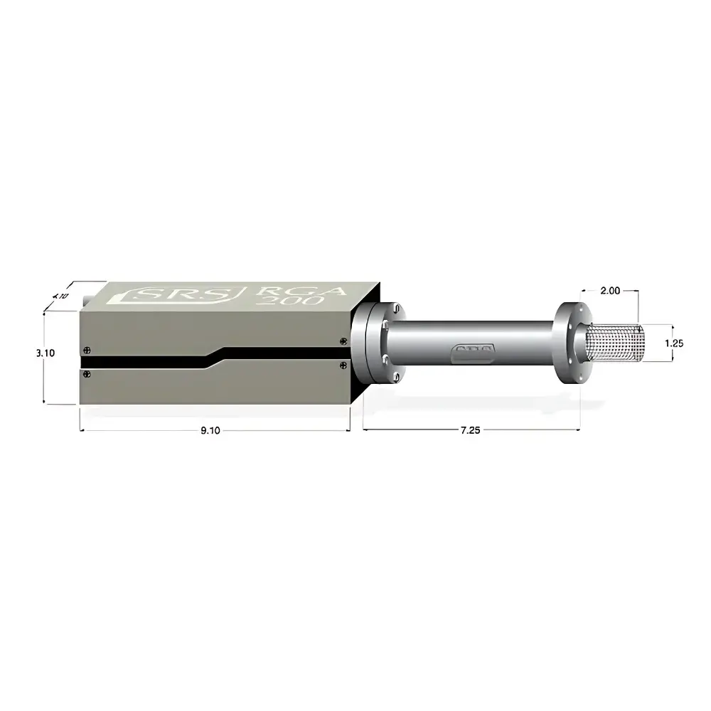
OptoTech MV-VNIR Airborne Miniature Hyperspectral Imaging System
| Brand | OptoTech |
|---|---|
| Origin | Beijing, China |
| Manufacturer Type | Authorized Distributor |
| Country of Origin | China |
| Model | MV-VNIR |
| Pricing | Upon Request |
| Operating Principle | Push-broom Scanning |
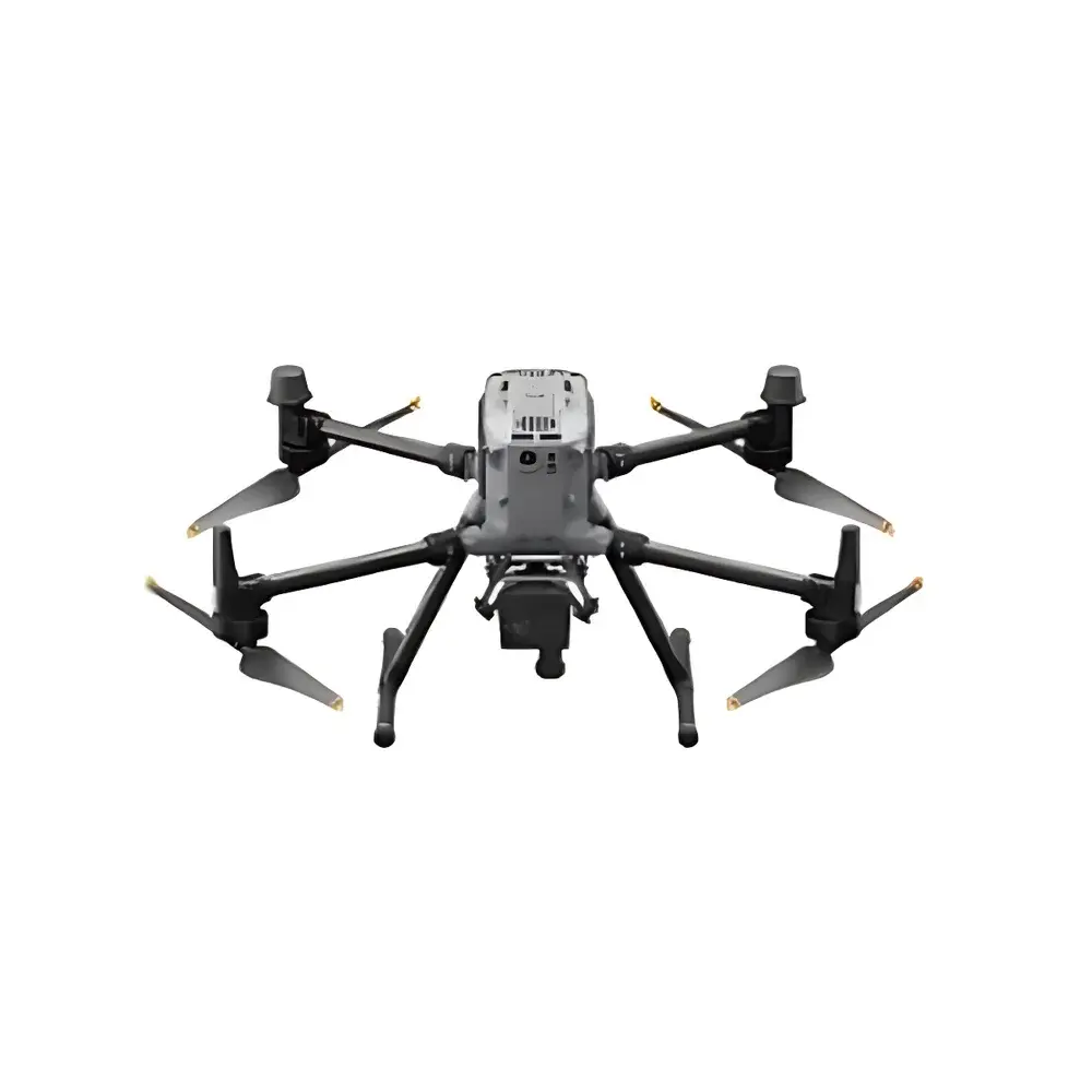
| Deployment Platform | UAV-mounted |
| Spectral Range | 400–1000 nm |
| Spectral Resolution | 6 nm (FWHM) |
| Spatial Resolution | 1024 pixels across track |
| Spectral Sampling Interval | 1.75 nm/pixel |
| Aperture | f/2.5 |
| Detector | CMOS |
| Number of Spectral Bands | 342 |
| Optical Design | All-reflective concentric with aberration correction |
| Interface | USB 3.1 |
| Power Consumption | 5 V / 2.4 W (max) |
| Weight | < 1 kg |
Overview
The OptoTech MV-VNIR Airborne Miniature Hyperspectral Imaging System is a compact, high-performance push-broom hyperspectral imager engineered specifically for integration with small-to-medium unmanned aerial vehicles (UAVs). It operates on the principle of spatial-spectral scanning—where continuous forward motion of the platform enables line-by-line spectral acquisition across a two-dimensional scene. The system captures contiguous spectral data cubes (x, y, λ) in the visible and near-infrared (VNIR) domain (400–1000 nm), enabling quantitative material identification, spectral unmixing, and biophysical parameter retrieval at sub-meter ground sampling distances (GSD). Its all-reflective concentric optical architecture eliminates chromatic aberration inherent in refractive designs, delivering high optical throughput, excellent linearity in dispersion, and robust performance under variable thermal and mechanical conditions typical of airborne operations.
Key Features
- All-reflective concentric optical design with integrated aberration correction—ensures high MTF, minimal spectral smile/keystone, and stable focus across the full VNIR band
- Push-broom acquisition mode optimized for UAV flight dynamics: supports real-time georeferencing when synchronized with GNSS/IMU systems (e.g., D-RTK 2 or equivalent)
- Compact form factor (<1 kg, volume < 1.2 L) and low power draw (5 V / 2.4 W max) compatible with payload-limited platforms including DJI Matrice 300 RTK and M350 RTK
- High spatial resolution (1024 pixels cross-track) coupled with 342 spectral bands sampled at 1.75 nm/pixel—enabling fine spectral feature discrimination (e.g., chlorophyll absorption at 680 nm, water absorption at 970 nm)
- Native USB 3.1 interface for direct onboard data streaming or buffered acquisition; firmware supports trigger synchronization with external sensors (LiDAR, thermal cameras, RGB frame grabbers)
- Designed for field-deployable ruggedness: operational temperature range −10 °C to +50 °C; shock/vibration compliant per MIL-STD-810G for rotary-wing UAV integration
Sample Compatibility & Compliance
The MV-VNIR is not sample-contacting and requires no consumables or calibration standards during routine operation. It is intended for remote sensing of natural and anthropogenic surfaces—including vegetation canopies, soil substrates, mineral outcrops, agricultural crops, coastal waters, and urban infrastructure. Data products comply with standard spectral data interchange formats (BSQ, BIL, BIP) and are fully ingestible by ENVI, QGIS (with HyperCube plugin), Python (scikit-image, spectral), and MATLAB. While not certified as a medical or regulatory-grade instrument, its radiometric stability and spectral fidelity support applications aligned with ASTM E2792 (Standard Guide for Hyperspectral Imaging), ISO 18290 series (Remote Sensing — Hyperspectral Imaging Systems), and FAO-recommended protocols for precision agriculture monitoring. System-level traceability to NIST-traceable reflectance standards (e.g., Spectralon® panels) is supported via optional onboard calibration routines.
Software & Data Management
The MV-VNIR includes OptoTech’s proprietary UAV-HSI Control Suite—a Windows-based application supporting real-time preview, exposure control, GPS/IMU metadata embedding, and lossless raw data capture in TIFF-based binary format. Post-processing tools include dark current subtraction, flat-field correction, spectral smile compensation, and geometric rectification using rational polynomial coefficients (RPCs). Export modules generate ENVI-compatible .hdr/.dat files with embedded projection metadata (WGS84 UTM, WKT-compliant). For regulated environments, optional audit-trail logging and user-access controls align with GLP/GMP documentation requirements. Raw data integrity is preserved through checksummed file writing and optional SHA-256 hash generation per acquisition segment.
Applications
- Agricultural monitoring: NDVI, NDRE, canopy chlorophyll content estimation, early stress detection (water/nutrient deficiency, disease onset)
- Environmental surveying: Wetland mapping, invasive species detection, soil organic matter and iron oxide quantification
- Geological reconnaissance: Lithological classification, clay mineral mapping (e.g., kaolinite, smectite), hydrothermal alteration zone delineation
- Forestry management: Species identification, biomass estimation, post-fire regrowth assessment
- Urban remote sensing: Material classification (roofs, roads, facades), solar reflectance analysis (SRI), impervious surface mapping
- Water quality assessment: Chlorophyll-a concentration, suspended sediment load, CDOM (colored dissolved organic matter) estimation in inland and coastal waters
FAQ
Is the MV-VNIR calibrated at the factory?
Yes—each unit undergoes spectral and radiometric calibration using NIST-traceable sources prior to shipment. A calibration certificate with wavelength accuracy (±0.5 nm) and relative spectral response (RSR) curves is provided.
Can it be used on fixed-wing UAVs?
Yes—the system supports configurable scan rates (10–120 Hz) and external TTL triggering, making it suitable for both multirotor and fixed-wing platforms with stable forward velocity profiles.
Does it support real-time onboard processing?
No—real-time spectral analysis is not performed onboard. However, raw data streaming over USB 3.1 enables near-real-time ground-station visualization and basic indexing (e.g., band ratio maps) with latency < 200 ms.
What GNSS/IMU systems are recommended for georeferencing?
DJI D-RTK 2, Emlid Reach RS2+, or APX-15, when configured with lever-arm compensation and time-synchronized PPS output, yield optimal orthorectification accuracy (< 0.5 m CEP).
Is SDK access available for custom integration?
Yes—an official C++/Python SDK with API documentation, sample code, and callback hooks for metadata injection and trigger management is available under NDA to qualified integrators and research partners.
Related Products

")
")