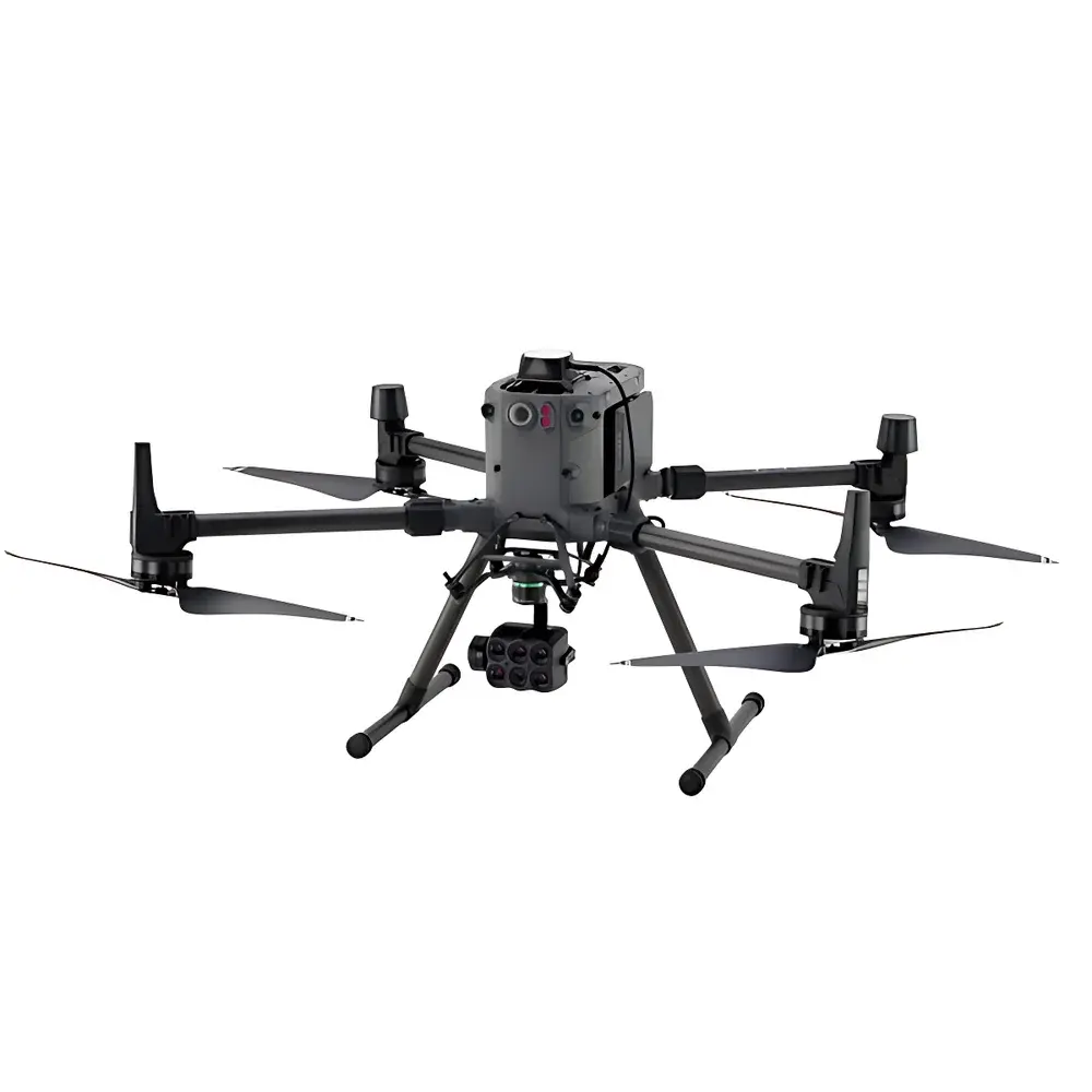
Sentera 6X Multispectral Imaging System
| Brand | Sentera |
|---|---|
| Origin | USA |
| Model | 6X |
| Spectral Channels | 5 × 3.2 MP global-shutter monochrome bands + 1 × 20.1 MP RGB band |
| Frame Rate | 3 fps |
| Integrated Onboard Processing | Yes |
| GPS & Illumination Sensor | Built-in |
| UAV Integration | MAVLink-compatible |
| Data Output | Radiometrically calibrated, georeferenced multispectral stacks (8-band) |
| Compliance | Designed for ASTM E2921-compliant remote sensing workflows |
| Software Interface | Compatible with Sentera FieldAgent, Agisoft Metashape, Pix4Dmapper, and QGIS via standard GeoTIFF/ENVI formats |
Overview
The Sentera 6X Multispectral Imaging System is a field-deployable, radiometrically calibrated airborne sensor engineered for high-fidelity spectral data acquisition in precision agriculture, environmental monitoring, ecological research, and infrastructure inspection. Operating on the principle of synchronized multispectral capture—leveraging five discrete narrowband spectral channels (typically centered at blue, green, red, red edge, and near-infrared wavelengths) alongside a high-resolution RGB channel—the 6X employs global-shutter CMOS sensors to eliminate motion-induced band misregistration common in rolling-shutter architectures. Each spectral band is optically filtered using hard-coated interference filters with <5 nm full-width-at-half-maximum (FWHM) bandwidths, ensuring spectral fidelity and minimizing cross-talk. The system’s integrated radiometric calibration pipeline—traceable to NIST-traceable reference panels—enables quantitative reflectance estimation without post-mission ground control targets in many operational scenarios.
Key Features
- Eight-channel synchronized acquisition: Five 3.2 MP monochrome spectral bands (customizable center wavelengths) plus one 20.1 MP RGB channel—all captured simultaneously with hardware-triggered global shutter timing.
- On-sensor real-time processing: Embedded FPGA and ARM-based co-processor execute geometric correction, radiometric normalization, vignetting compensation, and band-to-band registration during flight—outputting orthorectifiable GeoTIFF stacks with embedded EXIF and XMP metadata.
- Integrated GNSS + IMU + ambient light sensor: Provides precise geotagging (±2 m CEP typical), attitude-aware band alignment, and automatic exposure adjustment based on incident irradiance—critical for consistent time-series analysis.
- MAVLink-native communication protocol support: Enables seamless integration with PX4- and ArduPilot-based autopilots; supports mission-triggered capture, telemetry streaming, and parameter configuration via QGroundControl.
- Dual-mode operation: Configurable for either burst-capture (max 3 fps sustained) or time-lapse mode with programmable interval; onboard 128 GB eMMC storage buffers raw sensor data prior to compression and export.
- Field-ready mechanical design: IP64-rated enclosure, operating temperature range of −10 °C to +50 °C, and shock-mounted optics optimized for fixed-wing and multirotor UAV platforms.
Sample Compatibility & Compliance
The Sentera 6X is designed for aerial deployment on unmanned aerial systems with payload capacities ≥500 g and power supply stability within 7–28 V DC. It does not require external calibration targets during routine operation but supports reflectance panel-based absolute calibration per ASTM E2921-22 (“Standard Practice for On-Site Calibration of Multispectral Sensors”). Its spectral response functions are documented per ISO 12232:2019 Annex D methodology. Data outputs comply with FAO’s CropWatch metadata standards and are compatible with USDA-ARS crop health analytics pipelines. The system meets electromagnetic compatibility requirements per FCC Part 15 Class B and CE RED Directive 2014/53/EU.
Software & Data Management
Raw sensor data is output as 16-bit linear DN values in TIFF format with embedded geospatial metadata conforming to GDAL/OGR standards. Radiometric correction coefficients, lens distortion models, and spectral response curves are stored in sidecar JSON files. The Sentera FieldAgent desktop application provides batch processing for NDVI, NDRE, GNDVI, and custom index generation, with optional cloud synchronization to AWS S3 buckets. All processing logs—including timestamped GPS positions, exposure settings, and calibration status flags—are retained for auditability under GLP-compliant workflows. Export formats include ENVI .hdr/.bin, Cloud Optimized GeoTIFF (COG), and CSV-based pixel-level spectral signatures for machine learning training sets.
Applications
- Precision agriculture: In-season nitrogen use efficiency mapping, irrigation stress detection, and yield prediction modeling via time-series vegetation index trends.
- Ecological assessment: Species classification in mixed forest canopies using red-edge/NIR separability; wetland delineation via water index thresholds.
- Environmental compliance: Monitoring tailings pond turbidity, landfill methane seepage proxies (via thermal-NIR correlation), and post-fire regrowth quantification.
- Infrastructure health: Detection of asphalt oxidation, concrete chloride ingress, and photovoltaic panel soiling through spectral anomaly clustering.
- Academic remote sensing: Validation of radiative transfer models (e.g., PROSAIL) using in situ spectroradiometer-collected ground truth spectra.
FAQ
Does the 6X require post-flight ground calibration for scientific-grade analysis?
No—radiometric calibration is performed onboard using factory-derived coefficients and validated against NIST-traceable reflectance standards. Ground truth panels are recommended only for absolute validation in critical applications (e.g., regulatory reporting).
Can the 6X be mounted on non-Sentera UAV platforms?
Yes—mechanical mounting interfaces follow standard 30 mm M3 screw patterns; electrical integration uses JST-GH connectors with documented pinout for power, UART, I²C, and trigger lines.
Is the 6X compliant with FDA 21 CFR Part 11 for agricultural bioassay documentation?
While the hardware itself is not a regulated medical device, its data provenance architecture—including immutable timestamps, user authentication logs, and electronic signature support in FieldAgent—supports Part 11-aligned audit trails when deployed in GxP-aligned agronomic trials.
What spectral band configurations are available beyond the default five-band setup?
Custom configurations—including dual NIR bands (850 nm + 900 nm), SWIR-capable variants (up to 1700 nm), and UV-enhanced options—are available under Sentera’s OEM engineering services program.
How is thermal drift managed during extended UAV missions?
The 6X incorporates thermally stabilized sensor housings and real-time dark-frame subtraction routines triggered by internal temperature sensors; performance remains within ±1.5% radiometric drift over 45-minute continuous operation.