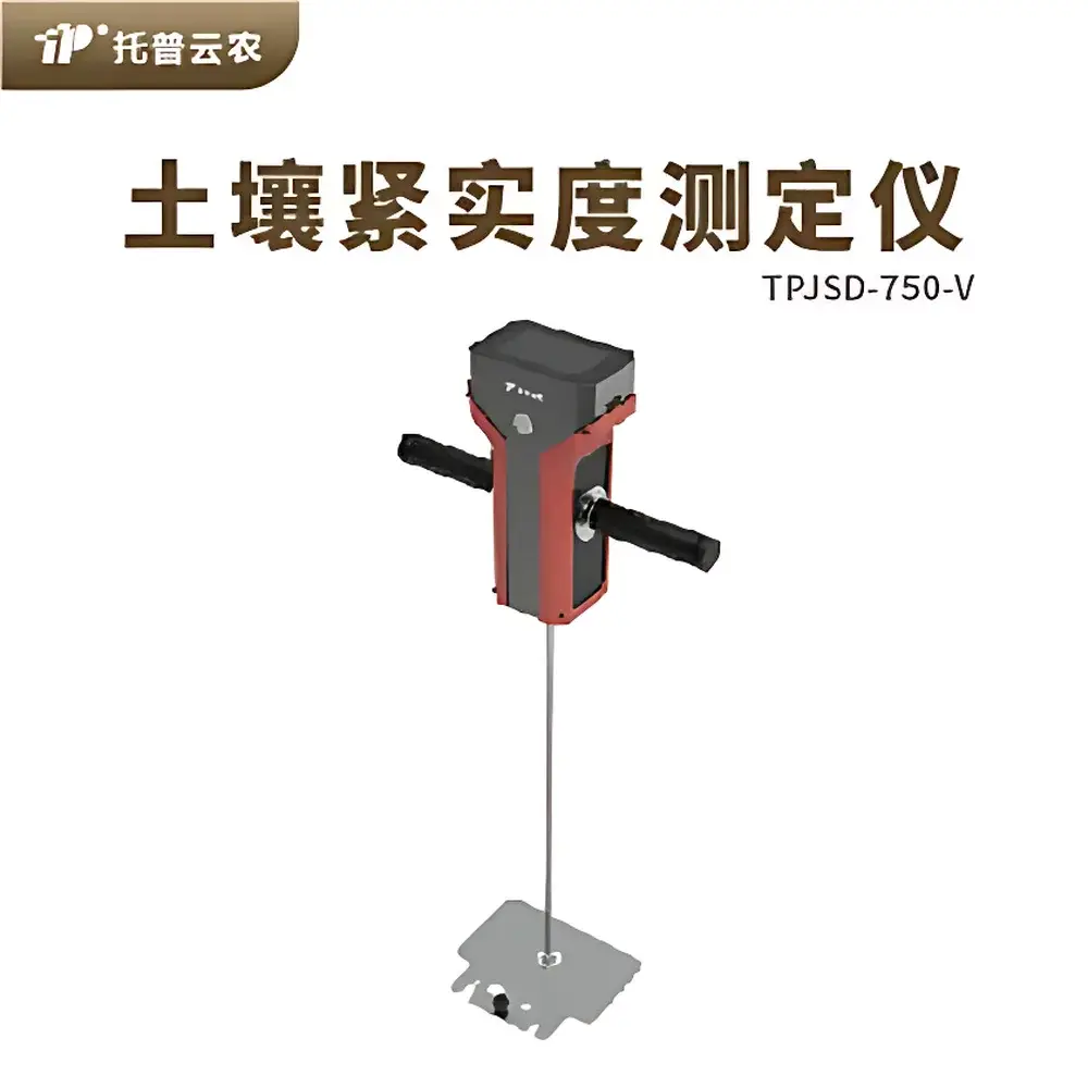
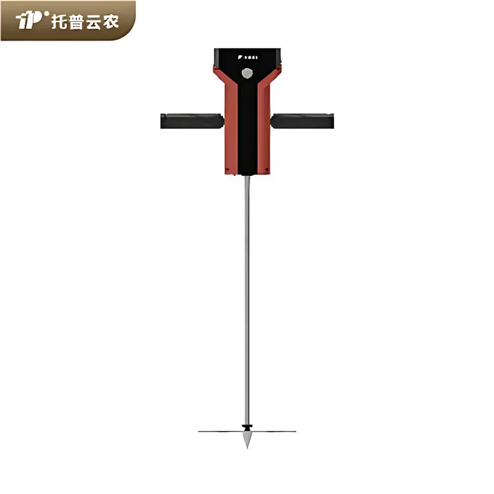
Top Cloud-agri TPJSD-750-V Soil Compaction Tester
| Brand | Top Cloud-agri |
|---|---|
| Origin | Zhejiang, China |
| Manufacturer Type | Manufacturer |
| Country of Origin | Domestic (China) |
| Model | TPJSD-750-V |
| Measurement Accuracy | ±2 cm |
| Measurement Depth | 0–450 mm |
| Probe Diameter | 9.53 mm |
| Small Cone Tip | Ø12.83 mm, 129 mm² |
| Large Cone Tip | Ø20.27 mm, 323 mm² |
| Measurement Units | kg/cm², N/cm², kPa, cm |
| Range (Small Cone) | 0–7500 kPa / 0–100 kg |
| Range (Large Cone) | 0–3000 kPa / 0–100 kg (120% over-range capability) |
| Resolution | 1 cm depth increment |
| Battery Capacity | 5000 mAh |
| Operating Temperature | –5°C to +55°C |
| Relative Humidity | 0–95% RH |
| Data Storage | >10,000 records |
| Continuous Operation Time | >10 h |
Overview
The Top Cloud-agri TPJSD-750-V Soil Compaction Tester is a field-deployable, handheld penetrometer engineered for quantitative assessment of soil mechanical resistance—commonly referred to as soil compaction. It operates on the principle of cone penetration testing (CPT), where a standardized conical probe is advanced vertically into undisturbed soil at a controlled quasi-static rate. The device measures the axial force required to overcome soil resistance at discrete depth intervals, enabling derivation of vertical profiles of soil strength (expressed in kPa, kg/cm², or N/cm²). This measurement directly correlates with root penetration impedance, water infiltration capacity, and aeration status—key indicators in agronomic management, land rehabilitation, and environmental impact assessment. Designed for compliance with ASTM D3441 and ISO 23782 standards for field penetrometry, the TPJSD-750-V integrates real-time depth-synchronized force acquisition, laser-assisted depth registration, and GPS-tagged georeferencing to support spatially explicit soil structure analysis.
Key Features
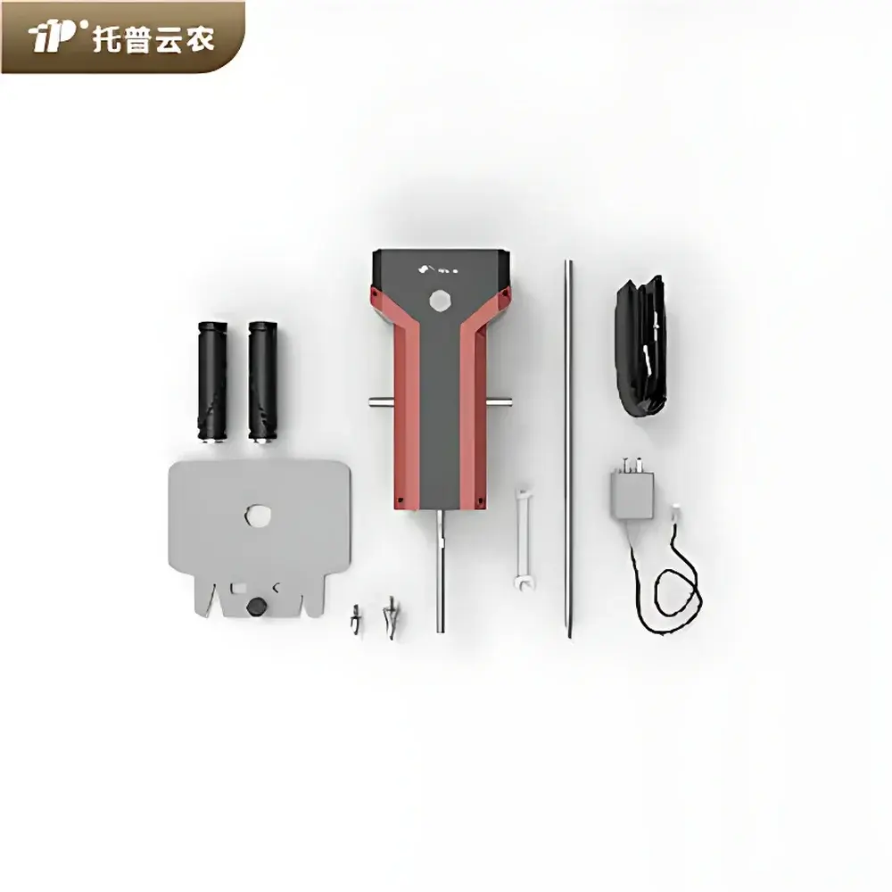
- Two interchangeable conical tips (129 mm² and 323 mm² cross-sectional area) optimized for variable soil textures—from dense clay to loose sand—ensuring appropriate stress distribution and minimizing localized disturbance.
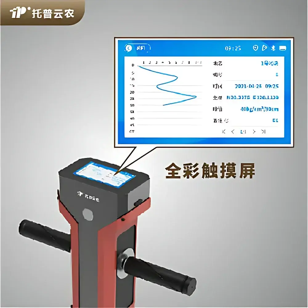
- Laser displacement sensor with 1 cm depth resolution enables precise, incremental recording of soil resistance vs. depth, supporting generation of continuous compaction profiles.
- Real-time insertion velocity monitoring: alerts user if probe advancement exceeds 3 cm/s, per ASTM D3441 recommendation for minimizing dynamic effects and ensuring quasi-static measurement fidelity.
- Integrated dual-axis inclinometer provides visual feedback on probe orientation; prompts corrective action when tilt exceeds ±2° from vertical, preserving measurement validity under field conditions.
- Depth pre-set function allows operator-defined termination depth (up to 450 mm); automatic measurement halt prevents over-penetration and ensures repeatability across sampling points.
- Onboard GPS module logs WGS84 coordinates for each measurement sequence, enabling GIS-integrated mapping and long-term spatial trend analysis.
- Cone wear diagnostic protocol: includes calibrated horizontal alignment plate to verify tip geometry integrity; worn cones exhibiting lateral clearance or misalignment are flagged for replacement to maintain traceable accuracy.
- High-capacity 5000 mAh Li-ion battery supports >10 hours of continuous operation under typical field duty cycles, including Bluetooth transmission and screen illumination.
Sample Compatibility & Compliance
The TPJSD-750-V is validated for use across mineral soils classified under USDA texture classes—including silty loam, sandy clay, and gravelly loam—provided surface moisture content remains within the plastic limit range (i.e., not saturated nor desiccated). It is unsuitable for rocky substrates (>15% stone content by volume) or highly organic horizons (e.g., peat >75% OM) due to non-uniform resistance response. The instrument conforms to calibration traceability requirements outlined in ISO/IEC 17025:2017 for field-testing equipment. Force transducer linearity and depth encoder accuracy are verified annually against NIST-traceable reference standards. All firmware and data logging routines comply with ALCOA+ principles (Attributable, Legible, Contemporaneous, Original, Accurate, Complete, Consistent, Enduring, Available) to support GLP-compliant field studies and regulatory submissions.
Software & Data Management
Data acquisition and visualization are supported via the proprietary Top Cloud-agri FieldSync mobile application (iOS/Android), which establishes secure Bluetooth 5.0 pairing with the device. The app captures time-stamped, georeferenced penetration curves, stores metadata (operator ID, site ID, cone type, ambient temperature/humidity), and exports CSV/Excel-compatible files compliant with FAO’s SoLIM (Soil Landscape Inference Model) input schema. Raw datasets may be uploaded to the cloud-based Research Assistant Platform—a web portal supporting multi-user collaboration, statistical aggregation (e.g., mean bulk density proxy, critical compaction depth detection), and automated report generation aligned with ISO 2859-1 sampling plans. Audit trails—including user login history, data modification timestamps, and firmware version logs—are retained for ≥7 years to satisfy FDA 21 CFR Part 11 electronic record requirements where applicable.
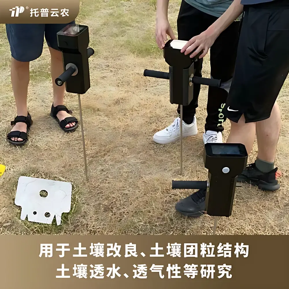
Applications
- Agronomic zone mapping: identification of subsoil compaction layers affecting root growth and yield potential in maize, wheat, and soybean production systems.
- Irrigation scheduling support: correlation of compaction depth with saturated hydraulic conductivity estimates to optimize drip emitter placement and furrow design.
- Construction site impact assessment: pre- and post-disturbance compaction profiling to quantify topsoil recovery rates following heavy machinery traffic.
- Restoration ecology monitoring: longitudinal tracking of soil structural recovery in post-mining reclamation sites using standardized cone index thresholds (e.g., >2.0 MPa indicating root-restrictive conditions).
- Educational field labs: hands-on instruction in soil physics principles, including stress-strain behavior, effective stress theory, and pedotransfer function development.
FAQ
What cone tip should I select for sandy loam soil?
For sandy loam—characterized by low cohesion and moderate internal friction—the large cone tip (323 mm²) is recommended to reduce point-load effects and improve signal-to-noise ratio during shallow (<20 cm) measurements.
Does the device require annual recalibration?
Yes. While factory-calibrated prior to shipment, users must perform annual verification using the included calibration verification kit and document results per ISO/IEC 17025 Clause 6.6. Calibration certificates are issued upon successful verification.
Can data be exported in shapefile (.shp) format?
Direct .shp export is not supported onboard, but CSV outputs containing latitude/longitude and penetration metrics can be imported into QGIS or ArcGIS and converted to point layers with attribute-driven symbology.
Is the unit suitable for frozen soil conditions?
No. Operation is restricted to temperatures between –5°C and +55°C; frozen or thawing soils introduce phase-change artifacts that invalidate mechanical resistance interpretation.
How is measurement repeatability ensured across operators?
Standardized training protocols—including insertion speed verification, tilt correction drills, and cone wear inspection—combined with digital audit trails in FieldSync ensure inter-operator consistency meeting ASTM D3441 repeatability criteria (±5% coefficient of variation for replicate tests at identical locations).