Top Cloud-agri TPSQ-W-1 Automated Soil Moisture Monitoring Station
| Brand | Top Cloud-agri |
|---|---|
| Origin | Zhejiang, China |
| Manufacturer Type | OEM/ODM Manufacturer |
| Country of Origin | China |
| Model | TPSQ-W-1 |
| Pricing | Upon Request |
Overview
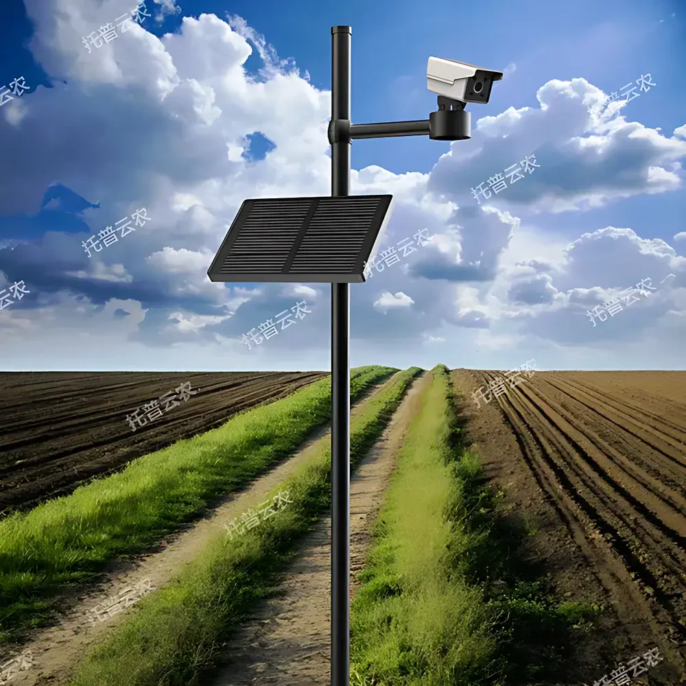
The Top Cloud-agri TPSQ-W-1 Automated Soil Moisture Monitoring Station is a field-deployable, solar-powered environmental monitoring system engineered for continuous, unattended measurement of soil water status and associated agronomic parameters. It operates on the principle of time-domain transmission (TDT) or frequency-domain reflectometry (FDR)—industry-standard dielectric methods for volumetric water content (VWC) quantification—combined with high-accuracy thermistor-based temperature sensing across four discrete soil depths. Integrated CMOS imaging captures phenological progression, while dual GNSS (GPS + BeiDou) enables georeferenced data attribution and anti-displacement verification. Designed for long-term deployment in open-field, greenhouse, and research plot environments, the station delivers time-synchronized, traceable datasets essential for irrigation scheduling, drought resilience planning, crop modeling validation, and regulatory soil moisture reporting under frameworks such as FAO’s Water Productivity Framework and ISO 11274:2023 (soil physical properties).
Key Features
- Hybrid Power Architecture: 15W monocrystalline solar panel + 220V AC backup; supports seamless power source switching and ensures >15 days of autonomous operation on internal Li-ion battery alone.
- Multi-Layer Soil Profiling: Four-tier sensor array measures VWC (0–100% VWC) and temperature (−40°C to +85°C) at configurable depths—enabling vertical moisture gradient analysis and root zone water budgeting.
- GNSS-Enabled Geospatial Integrity: Dual-band GPS/BeiDou module provides sub-5m horizontal accuracy, automatic altitude acquisition, and displacement detection via coordinate deviation algorithms—critical for asset security and spatial data fidelity.
- Phenocam Integration: 2 MP (1280×1080) CMOS sensor with 1/2.7″ optical format; motorized 360° pan-tilt mechanism; programmable timelapse capture with remote configuration of interval, duration, and image count.
- Embedded Real-Time OS: FREERTOS-based firmware ensures deterministic task scheduling, concurrent sensor polling, low-latency event handling, and robust fault isolation across I/O, communication, and storage subsystems.
- Industrial Connectivity: LTE Cat-1 modem (3G/4G fallback compatible); optional 5G upgrade path; TLS 1.2-secured MQTT/HTTP(S) uplink to cloud infrastructure; full support for mobile (iOS/Android) and web-based (B/S) remote management.
- Data Resilience & Compliance: Onboard microSD card supports ≥400,000 timestamped records (≥5 years at 15-min sampling); IP65-rated enclosure; IP68-rated soil probes; GLP-aligned audit trail for firmware updates (OTA), configuration changes, and alarm events.
Sample Compatibility & Compliance
The TPSQ-W-1 is validated for use in mineral soils (sand, loam, clay), organic substrates (peat, compost), and managed agricultural soils—including those under drip irrigation, flood irrigation, and conservation tillage. Sensor calibration adheres to ASTM D5193–22 (standard guide for soil moisture sensors) and ISO 11274:2023 (determination of soil water retention curves). Data output conforms to OGC SensorThings API v1.1 standards for interoperability with national agro-meteorological networks (e.g., China Meteorological Administration CMA-NAMC, USDA NRCS SCAN). The platform architecture supports 21 CFR Part 11-compliant electronic signatures and audit logs when deployed in GxP-regulated trials.
Software & Data Management
The Digital Agriculture Cloud Platform is a secure, multi-tenant SaaS application accessible via HTTPS-enabled browsers or native iOS/Android apps. It ingests, time-aligns, and contextualizes data from heterogeneous sources—including TPSQ-W-1 stations, portable probes, weather stations, and satellite-derived evapotranspiration layers. Core capabilities include: real-time parameter dashboards with min/max/avg trend overlays; customizable threshold-based alerts (email/SMS/push); automated ETo estimation using the FAO-56 Penman-Monteith equation (7-day forecast); dynamic relative water content (RWC) calculation incorporating user-defined field capacity and wilting point; root depth inference via moisture depletion profiling; and precipitation forecasting (48-hr and 15-day horizons) fused with local GNSS coordinates. All reports—tabular exports (CSV/XLSX), annotated graphs (PNG/PDF), and animated phenology sequences—are exportable with embedded metadata (sensor ID, location, UTC timestamp, QA flags).
Applications
- Irrigation advisory services for precision agriculture cooperatives and water user associations
- Long-term soil moisture network deployment for regional drought early-warning systems
- Field validation of hydrological models (e.g., SWAP, HYDRUS-1D) and satellite soil moisture products (SMAP, Sentinel-1)
- Controlled-environment research on crop water-use efficiency (WUE) and drought tolerance screening
- Regulatory compliance monitoring for sustainable groundwater abstraction permits
- Extension service delivery—real-time墒情 (shangqing) maps for county-level agricultural bureaus
FAQ
What soil types are supported for accurate VWC measurement?
The TPSQ-W-1 sensors are factory-calibrated for mineral soils (sand to clay loam); site-specific calibration is recommended for high-organic or saline soils (>4 dS/m EC).
Can the system operate without cellular coverage?
Yes—local data logging continues uninterrupted; uploads resume automatically upon network restoration, with no data loss.
Is the cloud platform compliant with EU GDPR or US HIPAA requirements?
The platform implements pseudonymization, encryption-at-rest/transit, and role-based access control; GDPR alignment is certified via annual third-party audit; HIPAA applicability is limited to non-healthcare use cases.
How often can images be captured, and what is the maximum storage duration?
Timelapse intervals range from 15 minutes to 24 hours; onboard storage retains ≥3,000 images; cloud archive duration is configurable (default: 90 days, extendable to 5 years).
Does the system support integration with farm management software (e.g., Climate FieldView, Granular)?
Yes—via RESTful API and CSV batch export; pre-built connectors available for major FMS platforms through Top Cloud-agri’s Partner Integration Program.


