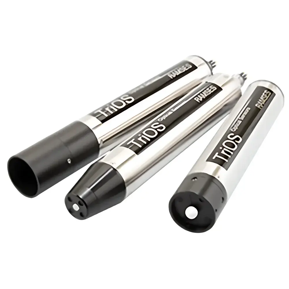
TriOS RAMSES UV/VIS High-Spectral Radiometer
| Brand | TriOS |
|---|---|
| Origin | Germany |
| Model | RAMSES |
| Measurement Range | UV (280–500 nm) / VIS (320–950 nm) |
| Detector | 256-channel silicon photodiode array |
| Spectral Sampling | 2.2–3.3 nm/pixel |
| Spectral Accuracy | ±0.2–0.3 nm |
| Cosine Response Error | <6–10% |
| Integration Time | 4 ms – 8 s |
| Response Time (Pulse Mode) | ≥16 s |
| Minimum Measurement Interval (Pulse Mode) | ≥8 s |
| Housing Material | Stainless Steel (1.4571/1.4404) or Titanium (3.7035) |
| Dimensions (L × Ø) | ACC: 260 × 48 mm, ASC: 245 × 48 mm, ARC: 300 × 48 mm |
| Weight | 0.9 kg (stainless), 0.7 kg (titanium) |
| Power Supply | 8–12 VDC (±3%) |
| Power Consumption | ≤0.85 W |
| Operating Temperature | +2 to +40 °C |
| Storage Temperature | −20 to +80 °C |
| Pressure Rating | 30 bar (SubConn) |
| Ingress Protection | IP68 |
| Flow Rate Compatibility | 0.1–10 m/s |
| Digital Interface | RS-232 (TriOS protocol) |
| Calibration Interval | 24 months |
| Maintenance Frequency | ≤0.5 h/month |
Overview
The TriOS RAMSES UV/VIS High-Spectral Radiometer is a field-deployable, modular optical sensor system engineered for quantitative spectral radiometric measurements in aquatic and atmospheric environments. Based on the principle of dispersive spectroscopy using high-stability silicon photodiode array detectors, the RAMSES measures spectral irradiance (W·m⁻²·nm⁻¹), spectral radiance (W·m⁻²·nm⁻¹·sr⁻¹), and scalar irradiance (W·m⁻²·nm⁻¹) across ultraviolet (280–500 nm) and visible (320–950 nm) wavelength bands. Its compact form factor—sub-300 mm length and sub-1 kg mass—enables integration into autonomous platforms including profiling buoys, AUVs, UAV-mounted payloads, and handheld survey systems. Designed for long-term unattended operation in harsh environmental conditions, the RAMSES meets stringent requirements for ecological remote sensing, satellite validation campaigns, and climate-relevant optical oceanography.
Key Features
- Modular optical head architecture: Interchangeable sensor heads (ACC for cosine irradiance, ARC for radiance, ASC for scalar irradiance) allow mission-specific configuration without hardware redesign.
- High-fidelity optical design: Precision-ground cosine correctors with angular response deviation <6–10% across operational wavelengths; FOV optimized for air (7° half-angle) and isotropic (2π sr) scalar collection.
- Ruggedized pressure housing: Stainless steel (1.4571/1.4404) or titanium (3.7035) enclosures rated to 30 bar, certified IP68 for continuous submersion at depths up to 300 m.
- Low-power embedded electronics: Consumes ≤0.85 W at 8–12 VDC, enabling extended deployments on solar-battery or energy-harvesting platforms.
- Stable spectral calibration traceable to NIST-traceable standards: Factory calibration includes temperature-dependent correction coefficients and stray-light characterization per ZEISS optical specifications.
- Robust RS-232 serial interface compliant with TriOS binary protocol: Supports synchronous command-response operation, firmware updates, and real-time data streaming with timestamped metadata.
Sample Compatibility & Compliance
The RAMSES is validated for direct immersion in natural waters (fresh, brackish, marine), atmospheric boundary layer profiling, and ex situ laboratory benchtop use. Sensor heads are compatible with standard oceanographic mounting frames (e.g., Sea-Bird Electronics frame adapters), tripod-based terrestrial setups, and custom UAV gimbals. All configurations comply with ISO 17025-accredited calibration practices and support GLP/GMP-aligned data integrity workflows. For regulatory applications—including EPA Method 418.1 (oil-in-water), ASTM E275 (spectral transmittance), and ESA/CEOS satellite vicarious calibration protocols—the system delivers measurement uncertainty budgets consistent with Level-2 ocean color product requirements. Data provenance is maintained via embedded hardware timestamps, internal temperature logging, and configurable audit trails in TriOS software.
Software & Data Management
TriOS SensorControl and OCView software packages provide full instrument control, real-time visualization, batch processing, and export to netCDF-4/HDF5 formats compliant with CF-1.8 conventions. The software supports automated dark-current subtraction, nonlinearity correction, temperature compensation, and spectral convolution for match-up with satellite sensors (e.g., Sentinel-3 OLCI, MODIS-Aqua). Raw spectra include embedded calibration coefficients, detector gain settings, integration time, and environmental telemetry (housing temperature, pressure). Exported datasets contain full metadata headers required for FAIR (Findable, Accessible, Interoperable, Reusable) data principles and are compatible with NASA’s SeaDAS, ESA’s BEAM, and Python-based analysis stacks (xarray, PyOceanOptics). Audit logs record all user-initiated actions, parameter changes, and calibration events—meeting FDA 21 CFR Part 11 requirements for electronic records and signatures when configured with user authentication.
Applications
- Water quality monitoring: Quantification of CDOM absorption, chlorophyll-a fluorescence proxies, suspended particulate matter, and turbidity via spectral shape analysis.
- Satellite validation: Vicarious calibration of ocean color sensors through simultaneous above- and in-water radiometric measurements under controlled sky conditions.
- Photosynthetic active radiation (PAR) and UV-B dosimetry: Spectrally resolved actinic flux calculation for phytoplankton photophysiology and ecosystem stress modeling.
- Climate-relevant optical properties: Derivation of inherent optical properties (IOPs) including absorption (aph, adg, aCDOM) and scattering (bp) using inverse radiative transfer modeling.
- Polar and remote field campaigns: Autonomous operation in Arctic/Antarctic sea ice zones, high-altitude lakes, and volcanic lake systems where power, weight, and reliability are critical constraints.
- Ecological remote sensing: Ground-truthing of hyperspectral airborne imagery and UAV-based multispectral surveys for benthic habitat mapping and macroalgal bloom detection.
FAQ
What spectral resolution does the RAMSES achieve?
Spectral sampling ranges from 2.2 nm/pixel (UV models) to 3.3 nm/pixel (VIS models); effective optical resolution (FWHM) is determined by slit width and grating dispersion, typically 3–5 nm.
Can the RAMSES operate autonomously underwater for extended periods?
Yes—rated to 30 bar (≈300 m depth), IP68 sealed, and consuming <0.85 W, it is routinely deployed on moorings, profiling floats, and gliders with battery life exceeding 6 months at 15-minute sampling intervals.
How often must the instrument be recalibrated?
TriOS recommends factory recalibration every 24 months under normal field use; stability verification via onboard dark measurements and reference lamp checks is advised monthly.
Is the system compatible with third-party data acquisition platforms?
Yes—RS-232 ASCII and binary protocols are publicly documented; drivers and example code (Python, MATLAB, LabVIEW) are available from TriOS upon request.
Does the RAMSES meet international standards for ocean color validation?
Yes—it conforms to the protocols defined in the IOCCG Protocols for Satellite Ocean Color Sensor Validation (2020) and supports CEOS/WGCV radiometric calibration traceability frameworks.