UGT Wetland Groundwater Ecological Lysimeter
| Origin | Germany |
|---|---|
| Manufacturer Type | Authorized Distributor |
| Origin Category | Imported |
| Model | UGT Wetland Groundwater Ecological Lysimeter |
| Instrument Type | Soil Water Potential & Evapotranspiration Analyzer |
| Compliance | ASTM D5859, ISO 11274, DIN 4021, EU Directive 2000/60/EC (Water Framework Directive) |
| Data Integrity | FDA 21 CFR Part 11–compliant audit trail in ENVIdata software |
| Calibration Traceability | PTB (Physikalisch-Technische Bundesanstalt)–certified mass and hydrostatic pressure standards |
Overview
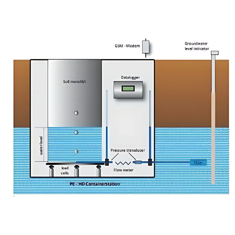
The UGT Wetland Groundwater Ecological Lysimeter is a high-precision, field-deployable weighing lysimeter system engineered for in-situ and ex-situ quantification of coupled hydrological, biogeochemical, and ecological processes in shallow groundwater wetlands. It operates on the principle of mass balance-based water flux determination—measuring changes in system mass at sub-millimeter equivalent resolution to resolve evapotranspiration (ET), infiltration, drainage, surface ponding, and capillary rise with temporal resolution down to 1 minute. Unlike conventional lysimeters, this system integrates real-time groundwater level emulation via a closed-loop hydraulic control architecture linked to natural aquifer heads, enabling dynamic replication of field-relevant water table fluctuations (0–2 m depth range) under controlled experimental conditions. Developed jointly by Prof. Ralph Meissner (UFZ Helmholtz Centre for Environmental Research) and UGT GmbH (Patent No. DE 19907462), it is specifically designed for ecologically sensitive, low-gradient hydromorphic soils—deltaic floodplains, riparian zones, peatlands, alpine fens, and other groundwater-fed ecosystems where water table dynamics govern biogeochemical cycling, root zone aeration, redox gradients, and greenhouse gas production.
Key Features
- Field-integrated or off-site deployable configuration: In-situ units are installed directly within native wetland substrate; ex-situ units maintain hydraulic equivalence to remote field sites via wireless groundwater level telemetry and automated servo-controlled balancing tanks.
- High-resolution weighing system: Load cell-based mass measurement with 0.01 mm water depth equivalent resolution, 1 Hz sampling, and configurable 15-minute averaging to suppress wind-induced noise and biological perturbations.
- Dynamic groundwater emulation: Closed-loop hydraulic control system maintains lysimeter water table within ±1 cm of target field level through sequential valve actuation, balanced tank pressurization/depressurization, and calibrated reservoir exchange—fully autonomous operation without manual intervention.
- Modular sensor integration: Standardized mounting layers at 30, 60, 90, and 120 cm depths accommodate TDR dielectric sensors, tensiometers, thermistors, and solution samplers—compatible with third-party probes meeting ISO 11276 and ASTM D5859 signal protocols.
- Dual-mode drainage quantification: Precision tipping-bucket collector (0.1 mm resolution) paired with continuous hydrostatic head monitoring enables independent validation of percolation volume and timing.
- Optional BTC-100 minirhizotron system: Non-destructive root growth imaging at up to 4 depth planes, synchronized with soil moisture and redox state data for rhizosphere process modeling.
Sample Compatibility & Compliance
The lysimeter accommodates undisturbed monoliths (1 m² surface area × 2 m height, standard; custom dimensions available) extracted using UGT’s patented in-situ soil coring system—preserving natural soil structure, macroporosity, organic horizon integrity, and root-soil continuity. Filter layer (25 cm gravel-sand matrix) ensures uniform drainage while preventing particle migration. All wetted components comply with DIN 19643 (drinking water safety) and EU REACH Annex XIV restrictions. System design adheres to ISO 11274 (soil water retention curve determination), ASTM D5859 (lysimeter performance criteria), and the European Water Framework Directive (2000/60/EC) requirements for groundwater-dependent ecosystem monitoring. Calibration certificates traceable to PTB national standards are provided for mass, pressure, and volumetric flow measurements.
Software & Data Management
Data acquisition and control are managed by ENVIdata v5.3—a modular, Linux-based platform supporting ISO/IEC 17025–aligned metadata tagging, GLP-compliant electronic signatures, and full 21 CFR Part 11 audit trails (user action logging, data modification history, electronic signature enforcement). Raw sensor streams (mass, water level, TDR permittivity, temperature, gas concentrations) are time-stamped with GPS-synchronized NTP precision. Wireless transmission uses LoRaWAN or LTE-M protocols to ENVIdata cloud servers; optional fixed-IP direct push to institutional servers is supported. Preconfigured water balance calculation modules implement the validated equation: P + Pond = ET + (Rout – Rin) ± ΔS, with automatic unit conversion, outlier detection, and gap-filling via linear interpolation constrained by physical bounds. Export formats include NetCDF-4 (CF-1.8 compliant), CSV, and SQL dumps for integration with SWAT, HYDRUS, or PEATCLSM modeling frameworks.
Applications
This lysimeter is deployed globally to quantify ecohydrological feedbacks in groundwater-wetland interfaces: quantifying ET partitioning (transpiration vs. evaporation) under variable water table scenarios; calibrating redox-sensitive solute transport models (e.g., nitrate reduction, Fe/Mn cycling); validating methane and CO2 flux parameterizations in response to water table drawdown; assessing contaminant leaching risk from agricultural or urban recharge zones; evaluating climate change impacts on peatland carbon storage; and supporting WFD Article 7 reporting on groundwater-dependent terrestrial ecosystems (GWDTEs). Published studies include long-term monitoring at the Schöningen Deich and Wörlitz floodplain sites (Germany), where it enabled first-time direct separation of drainage and ET components under winter hydrological conditions—revealing groundwater level as the dominant controller of soil moisture dynamics over atmospheric demand.
FAQ
What groundwater depth range can the system emulate?
The system is calibrated for stable, autonomous control across 0–2 m below surface, with optional extension to 3 m using reinforced balancing tank configurations.
Is soil coring included with the system?
Yes—the UGT patented in-situ monolith extraction rig (including hydraulic core barrel, vacuum stabilization, and transport cradle) is supplied as standard equipment.
How is gas flux measured, and what analytes are supported?
A modular gas sampling manifold supports sequential measurement of CO₂ (NDIR, 0–5 %, 0.0001 % res.), O₂ (fuel-cell, 1–100 %, 0.001 % res.), and CH₄ (external NDIR module, 0–10 %, 1 ppm res.), with baseline correction, temperature/pressure compensation, and programmable chamber cycling.
Can the system operate unattended for extended periods?
Yes—field-rated enclosures (IP66), solar-charged battery backup (72 h autonomy), and dual-path telemetry ensure >12-month continuous operation in remote wetlands with minimal maintenance.
Are software updates and calibration support included?
UGT provides 3 years of firmware/software updates and annual remote calibration verification via PTB-traceable reference standards—extendable under service-level agreements.
Related Products


