ZYKX Mobile On-Vehicle Soil and Water Conservation Experimental Monitoring System
| Brand | ZYKX |
|---|---|
| Origin | Beijing, China |
| Model | ZYKX |
| Application | Field-based soil erosion simulation, rainfall-runoff-sediment process monitoring, slope hydrology research |
| Rainfall Area | 8–50 m² (customizable) |
| Rainfall Height | ≤3.2 m |
| Rainfall Intensity Range | 15–150 mm/h |
| Raindrop Diameter | 0.5–6 mm (7 selectable classes, 3 pre-configured) |
| Rainfall Uniformity Coefficient | ≥0.85 |
| Rainfall Measurement Accuracy | ±0.01 mm/h |
| Rainfall Regulation Resolution | 5 mm/h |
| Sediment Concentration Range | 1–400 kg/m³ (±5% error <100 kg/m³ |
| Runoff Flow Rate Range | 3–2400 mL/s (±3% error) |
| Sampling Interval | 20–300 s |
| Slope Adjustment Range | 0–30° |
| Portable Steel Flume Dimensions | Adjustable from 2×4 m to 3×5 m |
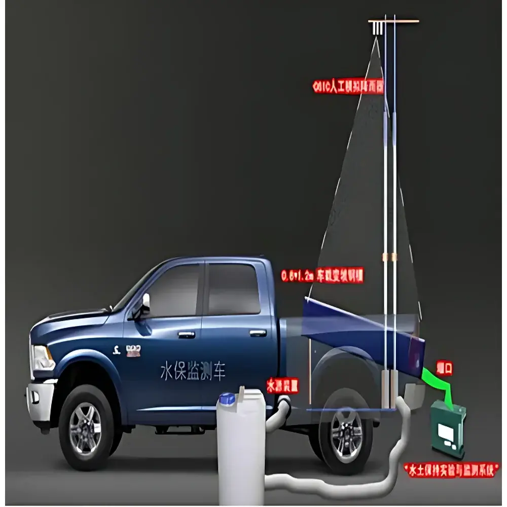
| Vehicle Platform | Great Wall Fengjun 5 pickup truck |
| Power Supply | Onboard generator + optional solar/battery backup |
| Data Transmission | Wireless telemetry (optional) |
| Compliance | Designed for ASTM D422, ISO 11277, USLE/RUSLE framework implementation, GLP-aligned data logging architecture |
Overview
The ZYKX Mobile On-Vehicle Soil and Water Conservation Experimental Monitoring System is a fully integrated, field-deployable platform engineered for quantitative, process-based investigation of rainfall-induced soil erosion dynamics under realistic topographic and hydrological conditions. Unlike stationary rainfall simulators or fixed-plot monitoring stations, this system implements a unified mobile laboratory architecture—mounting calibrated artificial rainfall generation, real-time runoff and sediment yield quantification, adjustable slope simulation, and embedded data acquisition onto a reinforced light-duty pickup chassis (Great Wall Fengjun 5). Its operational principle relies on controlled kinetic energy delivery via regulated droplet impact (0.5–6 mm diameter), coupled with high-temporal-resolution measurement of surface runoff velocity, volumetric flow rate, and suspended sediment concentration using optical and ultrasonic sensing modalities. The system supports both undisturbed in-situ soil plots and mechanically disturbed substrates, enabling direct empirical derivation of accelerated erosion coefficients (AEC) and baseline erosion rates—critical inputs for Universal Soil Loss Equation (USLE) and Revised USLE (RUSLE) parameterization in land-use planning and regulatory compliance documentation.
Key Features
- Integrated mobile platform eliminating need for permanent infrastructure: no concrete flumes, fixed rain towers, or site-specific power grid connections required.
- Modular artificial rainfall subsystem (ZYKX-10 derivative) featuring multi-MCU coordinated control, real-time intensity modulation (15–150 mm/h in 5 mm/h increments), and uniformity-certified nozzle arrays (≥0.85 coefficient).
- Automated sediment–runoff monitoring unit with dual-range turbidity calibration (1–100 kg/m³ at ±5% accuracy; 100–400 kg/m³ at ±10% accuracy) and gravimetrically validated flow metering (3–2400 mL/s, ±3% full-scale error).
- Adjustable steel flume assembly: telescoping retaining structure (2×4 m to 3×5 m footprint) with precision-machined circular weirs (5 cm diameter) and 2 mm structural steel plates, compatible with rapid slope reconfiguration (0–30°).
- Embedded control center with industrial-grade HMI, onboard data logger supporting timestamped CSV export, and optional LTE/WiFi telemetry for remote configuration and near-real-time dataset retrieval.
- Power-resilient architecture: primary diesel generator integration supplemented by optional solar panel array and sealed lead-acid battery bank for unattended multi-day deployments.
Sample Compatibility & Compliance
The system accommodates heterogeneous soil matrices—including loam, clay loam, sandy loam, and anthropogenically disturbed substrates—without sample preconditioning beyond standard field moisture equilibration. All sensor outputs conform to traceable metrological principles aligned with ISO/IEC 17025 foundational requirements for environmental testing laboratories. Data acquisition firmware enforces audit-trail logging per GLP guidelines, recording operator ID, calibration timestamps, environmental metadata (ambient temperature, barometric pressure), and instrument status flags. While not certified to FDA 21 CFR Part 11, the software architecture supports electronic signature-ready workflows and configurable user access levels—facilitating adoption in GMP-adjacent contexts such as watershed restoration validation studies commissioned under national ecological redline policies.
Software & Data Management
Data collection occurs via a deterministic real-time operating system (RTOS) executing at 100 Hz sampling resolution for flow and sediment channels. Raw sensor streams are buffered in non-volatile memory and synchronized with GPS-derived geotags and IMU-stabilized tilt compensation. Post-acquisition processing is performed using ZYKX’s proprietary MATLAB-based analysis suite (v4.2), which computes time-series erosion rates, kinetic energy fluxes, detachment efficiency indices, and sediment rating curves compliant with ASTM D422 grain-size correlation protocols. Export formats include netCDF-4 (CF-compliant), Excel-compatible .xlsx with embedded metadata schemas, and GIS-ready shapefiles containing spatially referenced event summaries. Cloud synchronization is available through encrypted HTTPS endpoints, supporting role-based dashboard access for project coordinators and third-party reviewers.
Applications
- Quantitative validation of erosion prediction models (e.g., WEPP, EUROSEM) across variable slope gradients and antecedent moisture conditions.
- Pre-construction baseline assessment and post-disturbance monitoring for linear infrastructure projects (pipelines, transmission corridors, roadways) under Chinese Ministry of Water Resources Technical Guidelines for Soil and Water Conservation Monitoring (SL 458–2022).
- Calibration of satellite-derived sediment yield proxies using ground-truthed event-scale measurements.
- Comparative evaluation of conservation measures (contour tillage, straw mulch, vegetation buffers) under replicated rainfall intensities.
- Graduate-level hydrology and geomorphology field pedagogy, supporting experiential learning in process-based earth surface dynamics.
FAQ
Can the system operate autonomously for extended unattended periods?
Yes—when equipped with solar charging and auxiliary battery storage, the system sustains continuous operation for up to 72 hours without refueling or manual intervention.
Is the rainfall simulator capable of replicating natural drop size distributions?
It provides discrete selection among seven standardized droplet spectra (DSDs); three are factory-defaulted to approximate convective, stratiform, and thunderstorm-type rainfall profiles per ISO 11277 Annex B recommendations.
How is sediment concentration calibrated in situ?
Calibration employs gravimetric suspension standards prepared from local soil samples, with cross-validation against ISO 11277 particle-size distribution curves.
Does the system meet international standards for erosion research?
Its measurement methodologies align with ASTM D422 (particle-size analysis), ISO 11277 (soil physical properties), and the conceptual framework of RUSLE2; formal certification is project-specific and requires third-party verification.
What maintenance intervals are recommended for field deployment cycles?
Nozzle inspection and cleaning every 20 operational hours; annual recalibration of flow and turbidity sensors against NIST-traceable reference materials; biannual structural integrity assessment of steel flume welds and mounting brackets.
Related Products


