Argus TMS3 Tree Stability and Anchorage Monitoring System
| Brand | Argus |
|---|---|
| Origin | Germany |
| Model | TMS3 |
| Weight | 73 g |
| Dimensions | 61 mm × 41 mm × 20 mm |
| IP Rating | Fully Sealed, Waterproof & Dustproof |
| Tilt Measurement Accuracy | ±0.03° |
| Sampling Frequency | 20 Hz (50 ms interval) |
| Measurement Axes | 3D (X/Y/Z, cardinal directions) |
| Operating Temperature Range | −20 °C to +50 °C |
| Battery Capacity | 250 mAh |
| Continuous Operation | >15 days |
| Charging | Wireless (Qi-compatible) |
| Data Storage | 256 MB (≈20 days at 20 Hz) |
| Communication | Bluetooth 2.1 |
| Sensor Mounting | Omnidirectional |
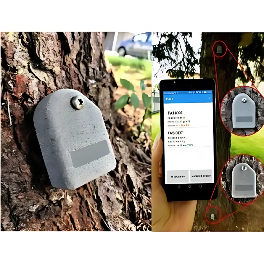
| Control Sensor Height | 2–3 m above ground |
| Base Sensor Placement | At root collar / anchorage zone |
Overview
The Argus TMS3 Tree Stability and Anchorage Monitoring System is an advanced, non-destructive field instrument engineered for quantitative assessment of tree mechanical stability under dynamic wind loading. It operates on the principle of high-resolution inertial tilt metrology—measuring minute angular displacements (pitch, roll, yaw) induced by natural or controlled lateral forces acting on the trunk and root-soil interface. Unlike conventional static pull tests, the TMS3 captures real-time, time-synchronized 3D tilt dynamics across two spatially decoupled sensing nodes: a base sensor mounted directly at the root collar to quantify anchorage compliance, and a control sensor positioned 2–3 m above ground to isolate stem flexure from true root-zone rotation. This dual-sensor architecture enables robust separation of biological response (root anchorage stiffness) from structural artifact (trunk bending), supporting empirical validation against Wessolly’s wind-load equivalence framework (Wessolly & Erb, 1998). Designed for long-term deployment in urban arboreal infrastructure, forestry, and ecological monitoring networks, the TMS3 delivers traceable, repeatable data suitable for risk-based arboricultural decision-making under ISO 14040 (LCA) and EN 12572-2 (tree safety assessment) contexts.
Key Features
- Ultra-lightweight design (73 g) with compact footprint (61 × 41 × 20 mm) enabling rapid, minimally invasive installation on trunks of varying diameter and bark texture
- True 3D inertial measurement unit (IMU) with integrated digital compass and GPS geotagging—ensuring spatially referenced, orientation-agnostic data acquisition
- High-fidelity sampling at 20 Hz (50 ms resolution), capturing transient gust-response dynamics critical for modal analysis and damping coefficient estimation
- Hermetically sealed housing rated IP67—validated for continuous outdoor operation across temperate, humid, and freeze-thaw environments (−20 °C to +50 °C)
- Wireless Qi charging and low-power architecture supporting >15 days of autonomous logging without maintenance or battery replacement
- Dual-sensor differential measurement logic—eliminating environmental noise (e.g., ground vibration, adjacent canopy sway) through real-time baseline subtraction
- Bluetooth 2.1 interface for secure, low-latency configuration and data retrieval via Android/iOS mobile applications
- Onboard timestamp synchronization using GPS-derived UTC signals—ensuring cross-device temporal coherence in multi-tree network deployments
Sample Compatibility & Compliance
The TMS3 is compatible with broadleaf and coniferous species across urban, peri-urban, and semi-natural forest settings. Its non-invasive mounting system accommodates bark thicknesses from 2 mm to >25 mm without compromising sensor alignment or signal integrity. The system adheres to internationally recognized standards for arboricultural instrumentation, including DIN 18920 (tree risk assessment), ISO 14040/14044 (life cycle assessment of green infrastructure), and supports audit-ready data collection workflows compliant with GLP principles. While not a medical or clinical device, its measurement traceability aligns with metrological requirements defined in ISO/IEC 17025 for field-deployed environmental sensors. All firmware and calibration parameters are version-controlled and logged with immutable timestamps, satisfying documentation expectations for municipal tree inventories subject to public accountability or insurance review.
Software & Data Management
Data acquisition and post-processing are managed via the proprietary Argus ArborScan™ mobile application (iOS/Android), which provides real-time telemetry visualization, sensor health diagnostics, and over-the-air firmware updates. Raw binary logs (binary-encoded IMU + GPS + temperature streams) are exportable in CSV and HDF5 formats for integration into MATLAB, Python (NumPy/Pandas), or R-based analytical pipelines. The software implements automated tilt vector decomposition—separating gravitational reference components from dynamic displacement—and generates standardized outputs: time-series plots, wind-load equivalence curves (per Sinn/Wessolly/Erb methodology), and comparative anchorage stiffness indices across tree cohorts. All data files include embedded EXIF-like metadata (GPS coordinates, UTC timestamps, sensor IDs, battery voltage, temperature), ensuring full chain-of-custody for regulatory or litigation-support use cases.
Applications
- Urban tree risk screening: Identifying individuals exhibiting anomalous root-zone tilt (>0.5° at <90 km/h wind speed) for prioritized ground-penetrating radar (GPR) or resistograph investigation
- Construction impact monitoring: Establishing pre- and post-excavation baselines to detect progressive root plate destabilization near building foundations or utility trenches
- Pathogen impact assessment: Correlating tilt response deterioration (e.g., increased hysteresis, reduced damping ratio) with fungal decay confirmed via micro-core sampling or tomographic imaging
- Root regeneration tracking: Quantifying longitudinal improvement in anchorage stiffness following soil aeration, mycorrhizal inoculation, or hydrological remediation
- Calibration of static pull test protocols: Using observed natural-wind-induced tilt amplitudes to determine optimal load magnitudes and durations for subsequent controlled mechanical testing
- Long-term ecological monitoring: Integrating TMS3 datasets with meteorological station records to model species-specific wind resilience thresholds under climate change scenarios
FAQ
How does the TMS3 differentiate root movement from trunk bending?
The system deploys two synchronized sensors: one at the root collar (base) and one 2–3 m up the trunk (control). By subtracting the control sensor’s tilt vector from the base sensor’s, it isolates pure root-plate rotation while mathematically canceling out elastic stem deformation.
Can the TMS3 operate during heavy rain or snow?
Yes—the fully sealed, IP67-rated enclosure has been validated for uninterrupted operation under sustained precipitation, snow accumulation, and freeze-thaw cycling between −20 °C and +50 °C.
Is GPS positioning required for accurate tilt measurement?
No—GPS is used solely for georeferencing and UTC time synchronization; tilt accuracy (±0.03°) is derived entirely from the onboard MEMS gyroscope and accelerometer array, independent of satellite signal availability.
What is the maximum recommended deployment duration without data offload?
At default 20 Hz sampling, the internal 256 MB memory supports approximately 20 days of continuous recording. For longer campaigns, scheduled Bluetooth sync or periodic manual retrieval is advised.
Does the system comply with data privacy regulations such as GDPR when deployed in public spaces?
Yes—no personal identifiers are collected. GPS coordinates are stored only at tree-level granularity (not street address), and all wireless communication uses encrypted Bluetooth pairing; raw data remains under full user ownership and local control.