GaiaSky-mini Push-broom Airborne Hyperspectral Imaging System
| Origin | Sichuan, China |
|---|---|
| Manufacturer Type | Distributor |
| Origin Category | Domestic |
| Model | GaiaSky-mini |
| Price Range | USD 140,000 – 280,000 (based on ¥1–2M at 7.1 CNY/USD) |
| Operating Principle | Push-broom scanning |
| Imaging Mode | 3D spatial-spectral data cube |
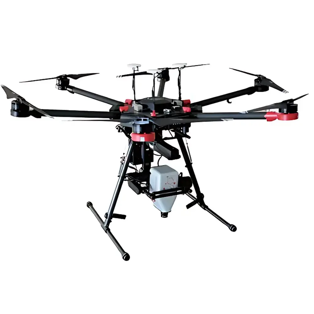
| Platform | Airborne (rotor UAV-mounted) |
| Spectral Range | 400–1000 nm |
| Spectral Resolution | 3.5 nm (FWHM) |
| Spatial Resolution (detector) | 960 × 1040 pixels |
| Total Field of View (TFOV) | Configurable per lens option (17/18.5/23 mm) |
| Instantaneous Field of View (IFOV) | 0.16–0.23 m @ 300 m AGL |
| Frame Rate | Up to 160 line images/s (GaiaSky-mini2-VN, USB 3.0) |
| Optical Aperture | f/2.8 |
| Detector | Sony ICX674 CCD (GaiaSky-mini2-VN), 14-bit output |
| Pixel Pitch | 4.54 µm |
| Interface | USB 3.0 |
| Power Supply | 12–19 V DC |
| Power Consumption | 45 W |
| Weight | 1.5 kg (integrated camera + internal controller) |
| Onboard Storage | 240 GB SSD |
| Mounting Envelope | ≥330 × 200 × 260 mm (H×W×D, suspension height included) |
| Compatible Platforms | DJI Matrice 600 Pro, S1000+, and other stabilized rotor UAVs capable of hover-based acquisition |
Overview
The GaiaSky-mini Push-broom Airborne Hyperspectral Imaging System is an engineered solution for high-fidelity spectral-spatial data acquisition from low-altitude, slow-moving, or stationary aerial platforms. Designed specifically for integration with rotor-type unmanned aerial vehicles (UAVs), it employs a proprietary internal push-broom scanning mechanism coupled with active stabilization—eliminating motion-induced smear and geometric distortion common in lightweight airborne hyperspectral systems. Unlike whiskbroom or snapshot architectures, the push-broom principle acquires one spatial line per integration time across the full spectral dimension using a linear array detector and precise mechanical scanning synchronized with platform motion. The system delivers calibrated 3D hyperspectral data cubes (x, y, λ) with contiguous spectral sampling from 400 to 1000 nm at 3.5 nm resolution (FWHM), enabling quantitative reflectance analysis under variable illumination conditions. Its operational design targets field-deployable remote sensing applications where portability, power efficiency, and real-time decision support are critical—including precision agriculture, environmental monitoring, mineral surface mapping, and defense-related spectral target discrimination.
Key Features
- Integrated push-broom scanning and inertial stabilization architecture—enables high-geometric-fidelity imaging without reliance on high-grade GNSS-INS units
- Hover-based acquisition mode—supports stationary flight operation, eliminating velocity-dependent scan-line misregistration
- Real-time onboard image stitching and georeferencing—leveraging auxiliary visible-light finder camera and embedded GPS/IMU fusion
- On-device radiometric and reflectance calibration—supporting batch processing of dark current, flat-field, and solar irradiance reference data
- Real-time vegetation index computation—NDVI, EVI, ARVI, NDWI, MSI, PRI, SIPI, NDNI, CRI1/2, ARI1/2, SAVI, PSRI, NDLI, CAI, and 17 additional indices compliant with USDA, FAO, and ESA spectral monitoring protocols
- Customizable real-time analytical model ingestion—accepts user-defined spectral algorithms via standardized XML or JSON configuration files
- Native compatibility with ENVI, ERDAS IMAGINE, and Evince software suites—exports in BSQ/BIL/BIP formats with embedded metadata (wavelength, FWHM, acquisition time, GPS pose, exposure)
- Dual-lens optical interface—interchangeable 17 mm, 18.5 mm, and 23 mm focal length options to balance ground sampling distance (GSD) and swath width per mission profile
- USB 3.0 interface and embedded 240 GB SSD—enabling sustained line-rate capture up to 160 Hz (GaiaSky-mini2-VN variant) with zero frame drop
Sample Compatibility & Compliance
The GaiaSky-mini is optimized for reflective surface measurement under daylight illumination conditions. It supports non-contact, passive spectral acquisition from heterogeneous natural and anthropogenic surfaces—including vegetated canopies, soil substrates, inland water bodies, urban infrastructure, and painted or camouflaged materials. Calibration traceability follows NIST-traceable reflectance standards (e.g., Spectralon® panels) and adheres to ASTM E2795–21 (Standard Practice for Spectral Reflectance Measurements of Soil and Vegetation Surfaces). Data provenance and processing workflows comply with ISO 19115–2 metadata schema and support GLP-aligned audit trails when integrated with validated ground control station software. While not FDA 21 CFR Part 11 certified out-of-the-box, the system’s deterministic data pipeline and immutable raw file structure enable qualification for regulated environmental monitoring programs under EPA Method 1666 and EU Copernicus Land Monitoring Service specifications.
Software & Data Management
The GaiaSky Control Suite provides a Windows-based GUI for mission planning, real-time telemetry visualization, live spectral preview, and post-acquisition correction. All raw data are stored in hierarchical binary format with embedded EXIF-style headers containing GPS position (WGS84), altitude (barometric + RTK-corrected), attitude (pitch/roll/yaw), exposure parameters, and spectral calibration coefficients. Radiometric correction includes dark-frame subtraction, pixel response non-uniformity (PRNU) compensation, and solar irradiance normalization using onboard photodiode measurements. Reflectance conversion utilizes empirical line method (ELM) or pseudo-invariant feature (PIF) referencing. Batch processing supports multi-session alignment, orthorectification (via external DEM), and export to ENVI-compatible .hdr/.dat bundles. Software logs retain full operational history—including firmware version, sensor temperature, and storage I/O status—for reproducibility and QA/QC validation.
Applications
- Precision agriculture: Crop health assessment, nitrogen status mapping, irrigation optimization, and early disease detection via red-edge and NIR spectral response anomalies
- Environmental monitoring: Wetland delineation, chlorophyll-a concentration estimation in lakes/reservoirs, heavy metal contamination screening in soils, and invasive species identification
- Geological surveying: Lithological classification, clay mineral mapping, and hydrothermal alteration zone detection using continuum-removed absorption features near 2200 nm (note: extended range requires optional SWIR module)
- Defense & security: Camouflage detection, material identification (e.g., paint vs. foliage), and concealed object recognition through spectral unmixing and anomaly detection algorithms
- Forestry management: Canopy density estimation, species differentiation, and post-fire regeneration tracking using shortwave infrared (SWIR)-adjacent bands
- Urban remote sensing: Impervious surface mapping, rooftop material classification, and thermal stress indicator derivation via normalized difference built-up index (NDBI)
FAQ
What UAV platforms are officially supported?
The GaiaSky-mini is validated for DJI Matrice 600 Pro and S1000+ platforms. Mechanical and electrical integration kits—including vibration-damping mounts, power regulators, and CAN/UART telemetry bridges—are available for these airframes.
Is real-time georeferencing possible without RTK-GNSS?
Yes—standard GPS/IMU fusion enables sub-meter absolute geolocation; RTK upgrade improves horizontal accuracy to ≤3 cm RMS and supports direct georeferenced orthomosaic generation without ground control points.
Can the system operate in low-light or overcast conditions?
It is designed for solar-illuminated acquisitions only. Performance degrades below 30 klux incident irradiance; no active illumination or thermal band capability is included in the VNIR variant.
How is spectral calibration maintained during long-term deployment?
Factory calibration is valid for 12 months under stable thermal conditions. Users may perform field recalibration using portable white reference panels and onboard dark-current acquisition routines.
Does the system support automated flight path generation for grid-based surveys?
Yes—the ground control station includes mission planner tools that generate optimized push-broom-aligned flight lines based on desired GSD, overlap ratio, and lens focal length selection.