AERO MPL-1400U Airborne L-Band Dual-Polarization Microwave Radiometer
| Brand | AERO |
|---|---|
| Origin | Beijing, China |
| Manufacturer Type | Authorized Distributor |
| Country of Origin | China |
| Model | MPL-1400U |
| Pricing | Available Upon Request |
Overview
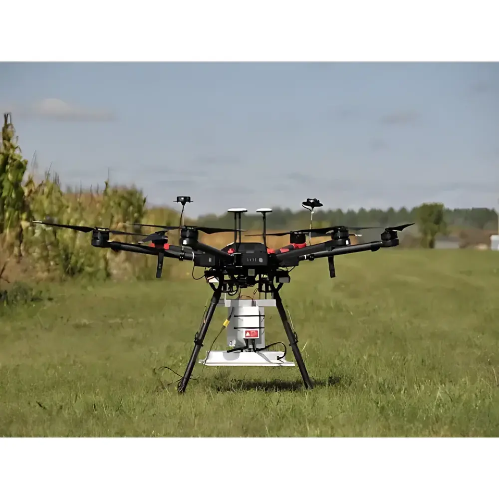
The AERO MPL-1400U is a high-sensitivity, dual-polarization airborne microwave radiometer operating in the L-band (1.40–1.427 GHz), engineered for quantitative passive remote sensing of Earth’s surface and lower atmosphere. It employs a microstrip patch array antenna with integrated polarization calibration capability, enabling full-Stokes parameter measurement (I, Q, U, V) under dynamic flight conditions. The system implements a calibrated Dicke-switched radiometric architecture with low-noise RF amplification, real-time digital backend processing, and on-board polarimetric computation. Its design conforms to the physical principles of thermal emission radiometry—measuring natural blackbody radiation from soil, vegetation, snow, and atmospheric water vapor—and delivers brightness temperature (TB) data with <1 K system noise temperature (Tsys) stability over 10-second integration intervals. As a key component in ecological and environmental remote sensing telemetry systems, the MPL-1400U supports mission-critical applications requiring spatially resolved, physically consistent geophysical retrievals under variable platform motion and ambient electromagnetic conditions.
Key Features
- Dual-polarization L-band radiometry with full-Stokes output (I, Q, U, V), supporting fractional polarization and polarization angle derivation
- Microstrip patch array antenna with embedded inertial measurement unit (IMU): triaxial accelerometer and gyroscope providing real-time motion-compensated attitude metadata (x/y/z acceleration, angular rates)
- On-board digital polarimeter and real-time TB processing engine, enabling immediate radiometric calibration and Stokes vector computation
- High spatial resolution enabled by narrow beamwidth (<3.5° at nadir) and precise geometric referencing via synchronized GPS/INS integration
- Robust airborne architecture: vibration-damped housing, wide operational temperature range (−20 °C to +60 °C), and EMI-hardened RF front-end compliant with DO-160 Section 20 Level A
- Modular subsystem design: RF chain, digital signal processor (DSP), control unit, and independent ground telemetry interface support field-replaceable maintenance and mission-specific configuration
Sample Compatibility & Compliance
The MPL-1400U is compatible with fixed-wing aircraft, rotary-wing UAVs, and high-altitude balloon platforms equipped with standard 28 VDC power and RS-422/RS-485 or Ethernet-based telemetry interfaces. It complies with ISO 11469 for material identification in aerospace enclosures and meets CE marking requirements for electromagnetic compatibility (EN 61000-6-2/-6-4). Radiometric calibration traceability follows NIST-traceable blackbody reference standards (±0.3 K uncertainty at 290 K), and data acquisition protocols align with NASA’s Airborne Science Data Management Standards (ASDMS v3.2). The system supports GLP-aligned metadata tagging—including time-synchronized IMU/GNSS stamps, instrument health logs, and raw counts with gain/offset coefficients—for audit-ready data provenance in regulatory or scientific validation workflows.
Software & Data Management
The MPL-1400U operates with AERO’s Radiometric Acquisition and Processing Suite (RAPS), a Linux-based application supporting real-time visualization, level-0 to level-2 data generation (TB → soil moisture, snow water equivalent, atmospheric column water vapor), and export in CF-compliant NetCDF-4 format. RAPS includes built-in motion compensation algorithms leveraging IMU-derived pitch/roll/yaw corrections, as well as optional integration with ESA’s SNAP or NASA’s ASF HyP3 for cross-platform interoperability. All data streams include embedded audit trails compliant with FDA 21 CFR Part 11 (electronic signatures, user access logging, immutable raw file hashing). Raw telemetry archives are stored in hierarchical directory structures with ISO 8601 timestamps, sensor configuration JSON manifests, and calibration coefficient versioning.
Applications
- Agricultural monitoring: high-resolution soil moisture mapping for precision irrigation scheduling and yield forecasting
- Hydrological modeling: validation of satellite-derived soil moisture products (e.g., SMAP, SMOS) and assimilation into land surface models (Noah-MP, CLM)
- Ecological assessment: detection of surface freeze/thaw state, wetland dynamics, and permafrost degradation indicators
- Snow characterization: estimation of snowpack density, liquid water content, and snow water equivalent (SWE) in mountainous terrain
- Atmospheric profiling: retrieval of integrated water vapor (IWV) and cloud liquid water path (LWP) under non-precipitating conditions
- Infrastructure surveillance: detection of subsurface moisture accumulation beneath roads, runways, and embankments
- EMI source localization: passive detection and geolocation of terrestrial L-band emitters through interferometric radiometric anomaly analysis
FAQ
What calibration standards does the MPL-1400U use?
The system performs internal cold-load/hot-load calibration every 30 seconds using NIST-traceable blackbody references; external absolute calibration is supported via flight over homogeneous natural targets (e.g., dry lake beds) following CEOS Cal/Val protocols.
Can the MPL-1400U operate simultaneously with other active sensors (e.g., SAR)?
Yes—the radiometer’s passive architecture and RF shielding meet MIL-STD-461G CS114 requirements, enabling co-deployment with L-band SAR without mutual interference.
Is the IMU data synchronized with radiometric measurements?
Yes—hardware-level PPS synchronization between the IMU and DSP ensures sub-millisecond timestamp alignment for motion correction during post-processing.
Does the system support automated georeferencing?
Yes—integrated GNSS/INS provides real-time position, velocity, and attitude (PVA) solutions; geocoded TB rasters are generated onboard using WGS84 ellipsoid and SRTM-based terrain correction.
What data formats are natively supported?
Level-0 (raw counts), Level-1A (calibrated TB), and Level-2 (geophysical retrievals) are exported in NetCDF-4 with CF-1.8 metadata conventions; ASCII and HDF5 variants are available upon request.
Related Products


