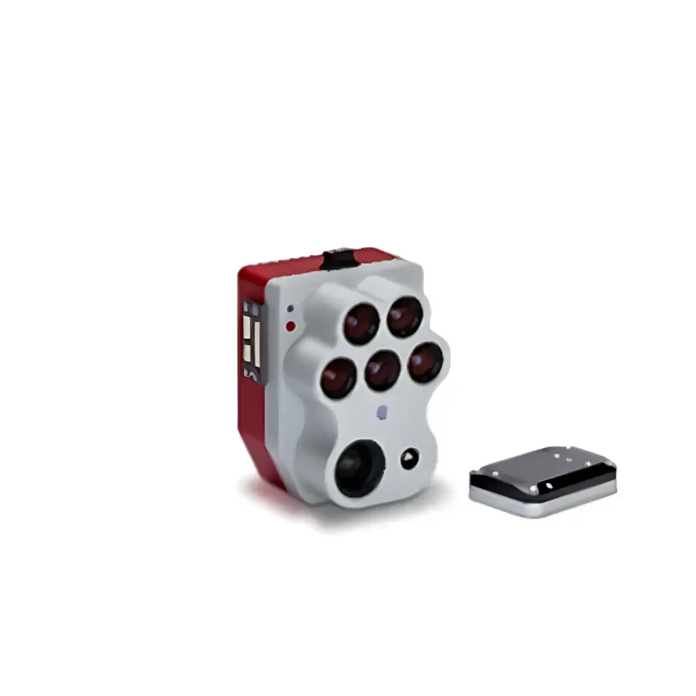
AERO RedEdge-P Airborne Multispectral Imaging System
| Brand | AERO |
|---|---|
| Origin | Beijing, China |
| Manufacturer Type | Authorized Distributor |
| Product Origin | Domestic (China) |
| Model | RedEdge-P |
| Pricing | Available Upon Request |
Overview
The AERO RedEdge-P is a professional-grade airborne multispectral imaging system engineered for high-precision remote sensing in scientific, agricultural, and environmental monitoring applications. Based on the proven MicaSense RedEdge-P platform and distributed by AERO (Beijing), this instrument integrates six synchronized spectral bands—five discrete multispectral channels (Blue, Green, Red, Red Edge, Near-Infrared) and one high-resolution panchromatic (PAN) channel—within a single, ruggedized enclosure. Its optical architecture leverages calibrated interference filters and global-shutter CMOS sensors to ensure radiometric stability and geometric consistency across flight campaigns. The system operates on the principle of push-broom–assisted frame capture with precise GPS/IMU synchronization, enabling georeferenced, radiometrically corrected imagery suitable for quantitative reflectance analysis. Designed for integration onto UAVs and light aircraft, the RedEdge-P delivers consistent data acquisition at operational altitudes up to 120 m, with native spatial resolution scalable to ≤2 cm at 60 m AGL when combined with PAN sharpening algorithms.
Key Features
- Integrated six-channel sensor suite: five 1.2 MP multispectral bands + one 5.1 MP panchromatic channel, all co-aligned and temporally synchronized
- Panchromatic sharpening capability enabling sub-2 cm ground sampling distance (GSD) at 60 m altitude—validated under controlled flight conditions
- Onboard radiometric calibration using factory-characterized reflectance panels and dark current compensation
- Embedded GNSS (GPS + GLONASS + BeiDou) and high-fidelity IMU (Inertial Measurement Unit) for centimeter-level geotagging accuracy
- Rugged aluminum alloy housing rated IP64 for dust and water resistance; operational temperature range: −10 °C to +50 °C
- Real-time image preview and metadata logging via USB-C or Ethernet interface; supports automated mission-triggered capture
Sample Compatibility & Compliance
The RedEdge-P is compatible with fixed-wing and multirotor UAV platforms equipped with standard mounting interfaces (e.g., DJI SkyPort, custom gimbal adapters) and sufficient payload capacity (>350 g). It acquires raw DNG files compliant with Adobe DNG 1.4 specification and embeds EXIF/XMP metadata including UTC timestamp, GPS coordinates, attitude angles (roll/pitch/yaw), exposure settings, and sensor temperature. Data workflows align with FAO’s CropWatch standards and support interoperability with photogrammetry software (e.g., Pix4Dmapper, Agisoft Metashape) and GIS platforms (QGIS, ArcGIS Pro). While not certified to ISO/IEC 17025, the system’s radiometric traceability follows NIST-traceable calibration protocols documented in the included Certificate of Calibration. It meets general requirements for environmental monitoring under ISO 19130-2 (Geographic information — Imagery sensor models) and supports QA/QC reporting for GLP-compliant field studies.
Software & Data Management
Raw data processing is supported through MicaSense’s Atlas cloud platform (subscription-based) and open-source tools such as OpenDroneMap and GDAL-based pipelines. The RedEdge-P outputs radiance-calibrated TIFF stacks and reflectance-converted GeoTIFFs when paired with reflectance panel captures. All firmware updates and configuration utilities are distributed via AERO’s secure technical portal. Audit trails—including capture logs, calibration history, and processing parameters—are retained per session and exportable in CSV/JSON format. For regulated environments, users may implement local deployment of processing scripts compliant with FDA 21 CFR Part 11 requirements (electronic signatures, audit trail retention, user access controls), though native electronic signature functionality is not embedded in the device firmware.
Applications
- Aquatic vegetation mapping: discrimination of submerged macrophytes and algal blooms via NDVI, NDRE, and floating algae index (FAI)
- Coastal and intertidal zone monitoring: detection of sediment plumes, seagrass meadow extent, and shoreline change dynamics
- Freshwater resource management: chlorophyll-a estimation in reservoirs and lakes using red-edge band ratios
- Early-stage pest and disease detection in row crops through subtle canopy reflectance anomalies before visible symptom onset
- Invasive species identification (e.g., water hyacinth, purple loosestrife) using supervised classification on multi-temporal spectral signatures
- High-throughput plant phenotyping: quantification of canopy cover, leaf area index (LAI), and nitrogen status in breeding trials
- Biodiversity and habitat assessment: classification of forest understory composition and wetland functional types
FAQ
Is the RedEdge-P compatible with DJI Matrice 300 RTK?
Yes—AERO provides validated mounting kits and SDK integration support for DJI’s Payload SDK v4.0 and above.
Does the system include factory radiometric calibration?
Yes, each unit ships with a NIST-traceable calibration certificate covering all six bands, valid for 12 months from date of shipment.
Can I process data offline without cloud subscription?
Absolutely—open-format DNG and GeoTIFF outputs enable full offline processing using QGIS, ENVI, or Python-based libraries (e.g., rasterio, scikit-image).
What is the maximum recommended flight speed for optimal GSD?
For stable 2 cm GSD at 60 m AGL, maintain forward velocity ≤8 m/s with ≥80% forward overlap and ≥60% sidelap.
Does AERO provide technical training and application support?
Yes—AERO offers on-site and virtual training modules covering flight planning, radiometric correction, index derivation, and validation against ground truth measurements.
")