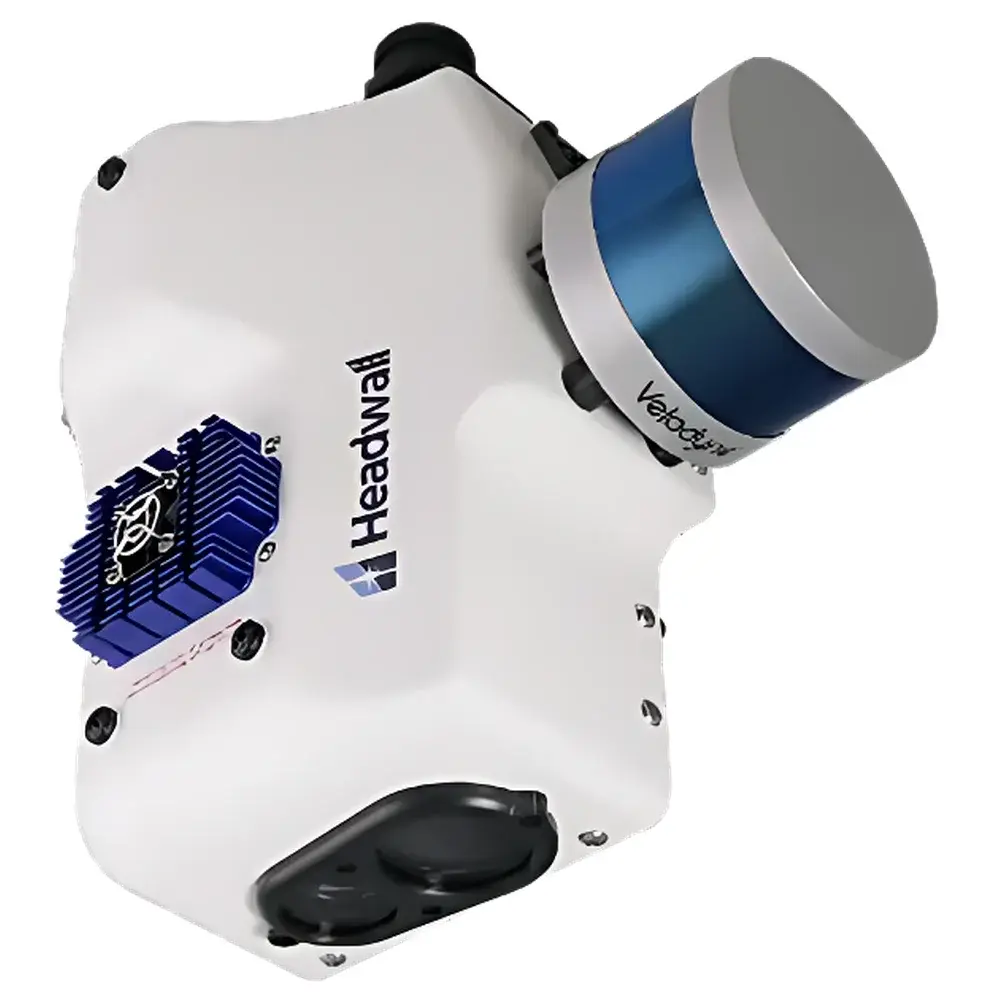
HeadWall Co-Aligned HP Full-Spectrum Hyperspectral Imaging Spectrometer
| Brand | HeadWall |
|---|---|
| Origin | USA |
| Manufacturer Status | Authorized Distributor |
| Import Status | Imported |
| Model | Co-Aligned HP |
| Operating Principle | Push-broom |
| Imaging Method | Dispersive |
| Deployment Mode | Ground-based & Airborne Compatible |
| Spectral Range | 400–1000 nm (VNIR) and 900–2500 nm (SWIR) |
| Spectral Resolution (FWHM) | 6 nm (VNIR), 8 nm (SWIR) |
| Spatial Resolution | 1020 px (VNIR), 640 px (SWIR) |
| Total Field of View (TFOV) | 12° (VNIR), 16° (SWIR) |
| Spectral Bands | 342 (VNIR), 267 (SWIR) |
| Weight | 4 kg |
| Optional Integration | 16-line LiDAR, Rotational Mount, High-Precision GPS/IMU |
Overview
The HeadWall Co-Aligned HP Full-Spectrum Hyperspectral Imaging Spectrometer is an engineered dual-band push-broom imaging system designed for high-fidelity spectral-spatial data acquisition across the visible-near infrared (VNIR: 400–1000 nm) and short-wave infrared (SWIR: 900–2500 nm) domains. Unlike sequential or scanning architectures, the Co-Aligned HP implements a true co-registered optical design—where VNIR and SWIR sensor paths are physically aligned within a single optomechanical housing, ensuring pixel-level spatial congruence between spectral cubes without post-acquisition geometric correction. This coaxial configuration leverages holographic transmission gratings and concentric reflective optics to preserve radiometric fidelity and minimize spectral smile and keystone distortion. The system operates on the push-broom principle: as the platform moves (e.g., UAV, aircraft, or ground vehicle), each line of the focal plane array captures a full spectrum for every spatial pixel along the swath—enabling high signal-to-noise ratio (SNR) and consistent illumination geometry across all bands. Its compact, ruggedized enclosure (4 kg total mass) integrates not only dual spectrometers but also synchronized data acquisition electronics, embedded real-time telemetry interface, and factory-calibrated GPS/IMU modules—making it suitable for both airborne survey missions and terrestrial field deployments under variable environmental conditions.
Key Features
- Dual-band co-alignment architecture with pixel-registered VNIR and SWIR data cubes, eliminating inter-band registration drift during motion-induced vibration or thermal cycling.
- Concentric optical design using custom holographic transmission gratings, optimized for minimal polarization sensitivity and high diffraction efficiency across both spectral ranges.
- High spatial sampling: 1020-pixel linear array (VNIR) and 640-pixel linear array (SWIR), supporting ground sample distances (GSD) down to sub-centimeter resolution at typical operational altitudes.
- Factory-characterized spectral response with FWHM ≤ 6 nm (VNIR) and ≤ 8 nm (SWIR), enabling robust discrimination of narrow absorption features (e.g., chlorophyll-a, cellulose, hydroxyl, and carbonate mineral signatures).
- Integrated high-precision GNSS/INS unit compliant with RTK-grade positioning (<10 cm horizontal accuracy) and 6-degree-of-freedom attitude measurement—critical for georeferencing and orthorectification in GIS workflows.
- Modular expansion support: native electrical and mechanical interfaces for optional 16-channel LiDAR integration, delivering synchronized 3D point clouds co-registered with hyperspectral reflectance data.
Sample Compatibility & Compliance
The Co-Aligned HP is deployed in environments requiring traceable, repeatable spectral measurements under field-realistic conditions—including outdoor vegetation canopy surveys, open-pit geological mapping, inland water body characterization, and non-invasive cultural heritage analysis. Its optical path is sealed and purged-ready (N₂-compatible), minimizing moisture-induced degradation in humid or dusty settings. All firmware and calibration metadata adhere to the ISO 17025-accredited calibration protocol used by HeadWall Photonics’ metrology lab. Data output conforms to ENVI-compatible BIL/BIP formats with embedded wavelength and radiometric calibration vectors. For regulated applications—such as environmental monitoring under EPA Method IO-3.2 or mineral exploration reporting per JORC Code—the system supports audit-trail logging and time-stamped raw frame capture compatible with GLP-compliant data management frameworks.
Software & Data Management
Acquisition and preprocessing are managed via HeadWall’s SpectraView Pro software suite, which provides real-time preview, exposure optimization, dark current subtraction, and onboard radiometric correction using NIST-traceable reference panels. The software exports calibrated reflectance cubes in standard HDF5 and GeoTIFF formats, preserving projection metadata (WGS84, UTM), sensor pose parameters, and band-specific SNR estimates. Batch processing pipelines integrate with open-source libraries (e.g., scikit-learn, HyTools) and commercial platforms including ERDAS IMAGINE and ArcGIS Pro through GDAL-compliant drivers. For secure enterprise deployment, SpectraView Pro supports role-based user access control and encrypted local storage—meeting baseline requirements for FDA 21 CFR Part 11 compliance when configured with electronic signature modules and immutable audit logs.
Applications
- Vegetation Phenotyping: Quantitative estimation of leaf area index (LAI), nitrogen content, water stress indices (NDWI, PRI), and species classification via spectral unmixing of canopy reflectance.
- Geological Mapping: Identification of alteration minerals (kaolinite, sericite, jarosite), lithological boundaries, and rare-earth element (REE) indicator minerals using SWIR absorption features near 2200 nm.
- Aquatic Remote Sensing: Retrieval of chlorophyll-a concentration, suspended sediment load, CDOM (colored dissolved organic matter), and harmful algal bloom (HAB) detection in lakes, rivers, and coastal zones.
- Cultural Heritage Documentation: Non-contact pigment identification, underdrawing visualization, and varnish degradation assessment through spectral library matching against reference databases (e.g., SPECIM, MOLAB).
- Soil Property Modeling: Prediction of organic carbon content, cation exchange capacity (CEC), and heavy metal contamination using partial least squares regression (PLSR) on continuum-removed SWIR spectra.
FAQ
Is the Co-Aligned HP capable of simultaneous VNIR and SWIR acquisition?
Yes—both spectral bands are acquired synchronously at the same scan line rate, with hardware-triggered frame alignment ensuring temporal coherence within ±10 µs.
What level of radiometric calibration is provided with the system?
Each unit ships with NIST-traceable absolute radiometric calibration certificates for both VNIR and SWIR channels, including temperature-dependent responsivity curves and stray-light correction matrices.
Can the system be mounted on rotary-wing UAVs?
Yes—the 4 kg mass, low center-of-gravity design, and shock-isolated mounting interface meet DO-160 Section 8 vibration and DO-160 Section 22 shock requirements for Class III UAV platforms.
Does the system support real-time onboard processing?
While primary operation is streaming raw data to external storage, optional FPGA-based edge processing modules enable real-time spectral index computation (e.g., NDVI, NDWI) and region-of-interest (ROI) flagging.
How is geometric distortion corrected in post-processing?
The integrated GPS/IMU enables rigorous sensor modeling via collinearity equations; HeadWall provides Python-based GeoCore tools for bundle adjustment, orthorectification, and DEM-driven terrain correction using external elevation models.


")