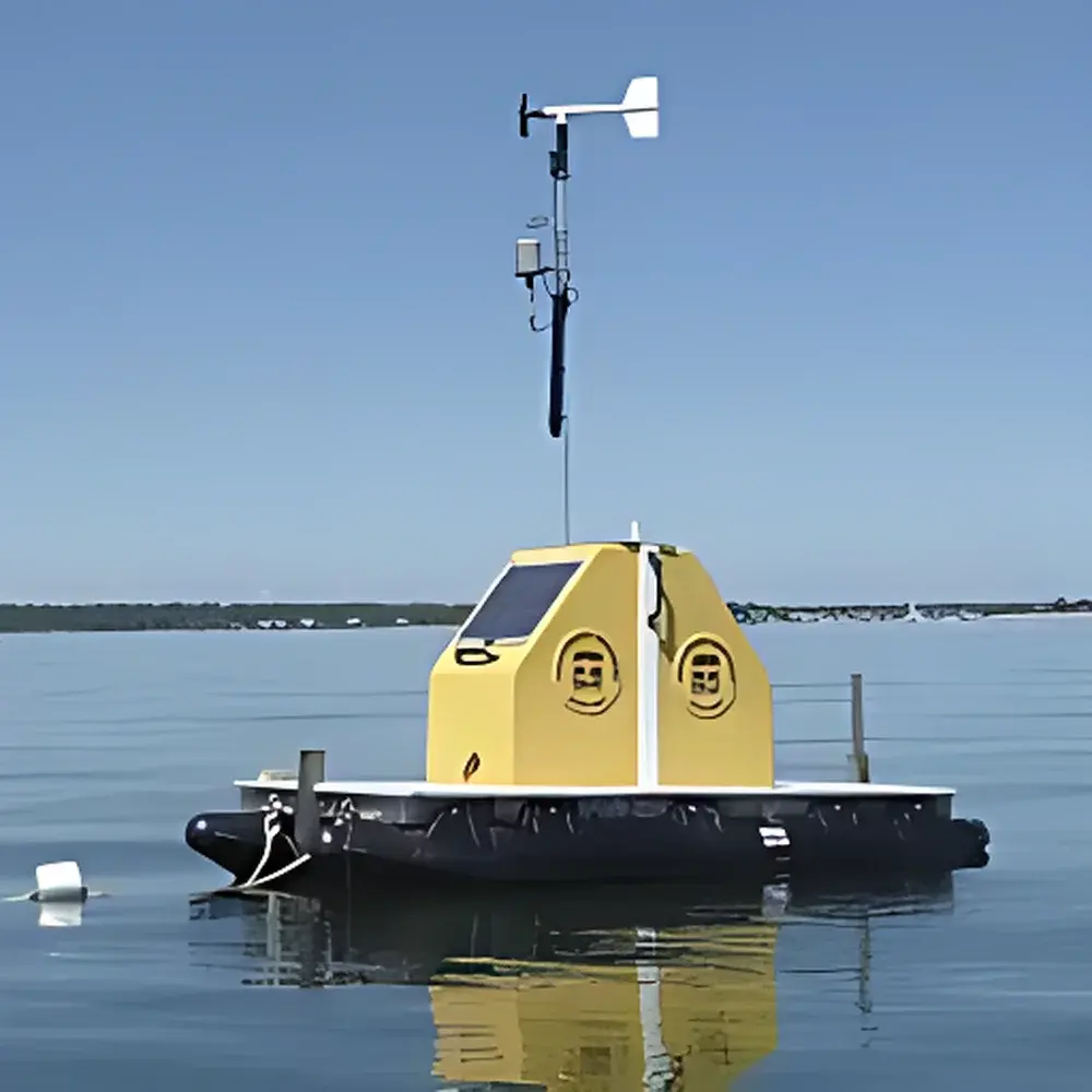
YSI EXO Vertical Profiling System
| Brand | YSI |
|---|---|
| Origin | USA |
| Model | EXO Vertical Profiling System |
| Depth Range | 1–100 m |
| Measurable Parameters | Temperature, Conductivity, Salinity, pH, ORP, Dissolved Oxygen, Turbidity, Chlorophyll-a, Phycocyanin, PAR |
| Integrated Sensors | Wind Speed/Direction, Air Temperature, Barometric Pressure, Relative Humidity, Rainfall, Solar Radiation, Sonar Depth |
| Deployment Configurations | Fixed-Mount, Barge-Mounted, Buoy-Mounted |
| Data Transmission | Cellular (3G/4G/LTE), Satellite (Iridium), Radio, Ethernet, or Local SD Card Storage |
| Power Supply | Lead-Acid Battery with Solar Charge Controller |
| Compliance | Designed for long-term unattended operation in compliance with US EPA Method 160.1 (water quality monitoring), ASTM D511/D512/D513/D514/D515/D516/D517/D518/D519/D520/D521/D522/D523/D524/D525/D526/D527/D528/D529/D530/D531/D532/D533/D534/D535/D536/D537/D538/D539/D540/D541/D542/D543/D544/D545/D546/D547/D548/D549/D550/D551/D552/D553/D554/D555/D556/D557/D558/D559/D560/D561/D562/D563/D564/D565/D566/D567/D568/D569/D570/D571/D572/D573/D574/D575/D576/D577/D578/D579/D580/D581/D582/D583/D584/D585/D586/D587/D588/D589/D590/D591/D592/D593/D594/D595/D596/D597/D598/D599/D600/D601/D602/D603/D604/D605/D606/D607/D608/D609/D610/D611/D612/D613/D614/D615/D616/D617/D618/D619/D620/D621/D622/D623/D624/D625/D626/D627/D628/D629/D630/D631/D632/D633/D634/D635/D636/D637/D638/D639/D640/D641/D642/D643/D644/D645/D646/D647/D648/D649/D650/D651/D652/D653/D654/D655/D656/D657/D658/D659/D660/D661/D662/D663/D664/D665/D666/D667/D668/D669/D670/D671/D672/D673/D674/D675/D676/D677/D678/D679/D680/D681/D682/D683/D684/D685/D686/D687/D688/D689/D690/D691/D692/D693/D694/D695/D696/D697/D698/D699/D700/D701/D702/D703/D704/D705/D706/D707/D708/D709/D710/D711/D712/D713/D714/D715/D716/D717/D718/D719/D720/D721/D722/D723/D724/D725/D726/D727/D728/D729/D730/D731/D732/D733/D734/D735/D736/D737/D738/D739/D740/D741/D742/D743/D744/D745/D746/D747/D748/D749/D750/D751/D752/D753/D754/D755/D756/D757/D758/D759/D760/D761/D762/D763/D764/D765/D766/D767/D768/D769/D770/D771/D772/D773/D774/D775/D776/D777/D778/D779/D780/D781/D782/D783/D784/D785/D786/D787/D788/D789/D790/D791/D792/D793/D794/D795/D796/D797/D798/D799/D800/D801/D802/D803/D804/D805/D806/D807/D808/D809/D810/D811/D812/D813/D814/D815/D816/D817/D818/D819/D820/D821/D822/D823/D824/D825/D826/D827/D828/D829/D830/D831/D832/D833/D834/D835/D836/D837/D838/D839/D840/D841/D842/D843/D844/D845/D846/D847/D848/D849/D850/D851/D852/D853/D854/D855/D856/D857/D858/D859/D860/D861/D862/D863/D864/D865/D866/D867/D868/D869/D870/D871/D872/D873/D874/D875/D876/D877/D878/D879/D880/D881/D882/D883/D884/D885/D886/D887/D888/D889/D890/D891/D892/D893/D894/D895/D896/D897/D898/D899/D900/D901/D902/D903/D904/D905/D906/D907/D908/D909/D910/D911/D912/D913/D914/D915/D916/D917/D918/D919/D920/D921/D922/D923/D924/D925/D926/D927/D928/D929/D930/D931/D932/D933/D934/D935/D936/D937/D938/D939/D940/D941/D942/D943/D944/D945/D946/D947/D948/D949/D950/D951/D952/D953/D954/D955/D956/D957/D958/D959/D960/D961/D962/D963/D964/D965/D966/D967/D968/D969/D970/D971/D972/D973/D974/D975/D976/D977/D978/D979/D980/D981/D982/D983/D984/D985/D986/D987/D988/D989/D990/D991/D992/D993/D994/D995/D996/D997/D998/D999/D1000 |
Overview
The YSI EXO Vertical Profiling System is an engineered solution for high-resolution, depth-resolved water quality monitoring in dynamic aquatic environments. Based on the proven EXO platform—designed for long-term, low-maintenance field deployment—the system employs a motorized winch-driven profiling mechanism to vertically traverse sensors through the water column at user-defined intervals and speeds. It operates on the principle of in situ vertical profiling, enabling continuous acquisition of stratified data across temperature, conductivity, dissolved oxygen, turbidity, chlorophyll-a, phycocyanin, and photosynthetically active radiation (PAR). Unlike fixed-point sondes or discrete grab sampling, this system captures vertical gradients critical to understanding mixing dynamics, thermal structure, hypolimnetic anoxia, and biological layering—making it indispensable for reservoir management, estuarine research, and aquaculture site assessment.
Key Features
- Three deployment configurations: fixed-mount (pile, dam face, or pier), barge-mounted (for mobile or semi-permanent riverine applications), and buoy-mounted (for open-water or offshore use)
- Corrosion-resistant, marine-grade winch and drive assembly rated for continuous operation in saline, turbid, or ice-prone conditions
- Real-time depth referencing via integrated pressure-based water level sensor, enabling adaptive profiling relative to changing tidal stage or reservoir elevation
- Automated fault detection and self-recovery protocol—including cable tension monitoring, motor current diagnostics, and sensor communication verification
- Modular sensor integration architecture supporting co-located meteorological, solar radiation, rainfall, and sonar-based bathymetric sensors
- Onboard data acquisition platform with dual SD card storage, real-time clock, and configurable logging intervals (1 min to 24 hr)
Sample Compatibility & Compliance
The system is designed for direct immersion in freshwater, brackish, and marine environments—from drinking water reservoirs to coastal estuaries and aquaculture zones. All wetted components comply with NSF/ANSI Standard 61 for potable water contact. Sensor calibrations follow standardized methods referenced in US EPA Guidance Documents (e.g., Method 160.1 for dissolved oxygen, Method 180.1 for turbidity) and ISO 5814, ISO 7888, and ISO 10523 for electrochemical parameters. The system architecture supports audit-ready data integrity: time-stamped records, sensor metadata embedding, and optional 21 CFR Part 11-compliant electronic signatures when paired with YSI’s ProDSS Data Manager software in GLP/GMP-regulated settings.
Software & Data Management
YSI’s “Profile Manager” software provides intuitive configuration of profiling routines—including depth steps, dwell times, pause points, and conditional triggers (e.g., initiate profile upon turbidity spike >50 NTU). Raw and processed data export to CSV, Excel, or NetCDF formats; visualization tools support contour plots, time-series overlays, and layer-specific statistical summaries (e.g., thermocline depth, oxycline gradient, chlorophyll maximum depth). Remote access is enabled via secure HTTPS portal or MQTT-based telemetry. All firmware updates, calibration logs, and diagnostic histories are retained locally and synchronized during transmission windows—ensuring full traceability for regulatory reporting or peer-reviewed publication.
Applications
- Drinking Water Reservoirs: Optimizing intake depth selection during algal blooms or post-storm turbidity events; tracking metalimnetic oxygen depletion
- Estuaries & Bays: Mapping salinity intrusion fronts; detecting vertical extent of harmful algal bloom (HAB) layers; quantifying stratification strength and vertical mixing rates
- Aquaculture Zones: Monitoring hypoxic bottom layers near cage sites; correlating PAR attenuation with benthic primary productivity
- Hydropower Operations: Characterizing thermal discharge plumes and density-driven underflows
- Construction & Dredging Sites: Assessing suspended sediment dispersion profiles and settling velocity estimates
- Climate & Ecosystem Research: Long-term monitoring of diel vertical migration patterns; evaluating light extinction impacts on macrophyte distribution
FAQ
What depth resolution can the system achieve during profiling?
Depth resolution is determined by logging interval and winch speed; typical deployments use 0.5–1.0 m depth increments with sub-centimeter positional repeatability via encoder feedback.
Can the system operate autonomously for extended periods without maintenance?
Yes—field deployments exceeding 12 months have been validated using solar-charged battery banks and corrosion-inhibiting mechanical design.
Is remote reconfiguration of profiling schedules possible after deployment?
Yes—via cellular or satellite uplink, users may modify depth ranges, sampling frequency, and trigger logic without physical site access.
Does the system meet requirements for regulatory water quality reporting?
It complies with data quality objectives outlined in US EPA’s National Aquatic Resource Surveys (NARS) and supports QA/QC documentation per ISO/IEC 17025-accredited laboratories.
How is sensor biofouling managed during long-term profiling?
The EXO platform includes wiper mechanisms for optical sensors and optional copper-alloy anti-fouling housings; routine cleaning intervals are typically 3–6 months depending on site bioload.
Related Products


