Tianhong TH-2012 Forward Scatter Visibility Sensor
| Brand | Tianhong |
|---|---|
| Model | TH-2012 |
| Measurement Principle | Forward scatter photometry |
| Visibility Range | 10 m to 50,000 m |
| Output Interval | 30–300 s (configurable) |
| Rainfall Measurement Range | 0.15–250 mm/h |
| Rainfall Accuracy | ≤10% |
| Optical Source | Pulsed infrared LED |
| Environmental Rating | IP65 |
| Power Consumption | Low-power design for unattended operation |
| Compliance | Designed for integration into automated environmental monitoring networks compliant with WMO No. 8 and GB/T 35222–2017 |
Overview
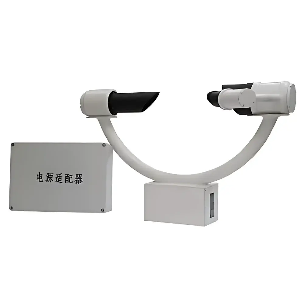
The Tianhong TH-2012 Forward Scatter Visibility Sensor is an optoelectronic instrument engineered for continuous, real-time measurement of atmospheric visibility under diverse meteorological conditions—including fog, drizzle, rain, snow, and haze. It operates on the principle of forward scatter photometry: a pulsed infrared light source (typically centered near 850 nm) emits collimated radiation into the atmosphere; suspended hydrometeors and aerosols scatter a portion of this beam in the forward direction (within a defined angular cone, typically 30°–45° from the incident axis); a calibrated photodetector collects this scattered intensity, which correlates inversely with extinction coefficient and, via Mie scattering theory and empirical calibration, is converted to meteorological optical range (MOR) in meters. Unlike transmissometers requiring long baselines, the TH-2012 achieves high spatial resolution and compact deployment while maintaining traceable performance across its full 10–50,000 m dynamic range—making it suitable for aviation weather observation, highway intelligent transportation systems (ITS), maritime navigation support, and national meteorological networks.
Key Features
- Optically optimized forward scatter geometry with internal baffle and anti-glare surface treatment to suppress secondary stray light and ensure long-term signal stability.
- Microprocessor-controlled embedded system enabling autonomous operation, self-diagnostic routines, and configurable output intervals (30 s to 300 s) to balance temporal resolution with data storage requirements.
- Integrated rainfall sensing capability using tipping-bucket or capacitive methodology (depending on configuration), supporting concurrent measurement of precipitation rate (0.15–250 mm/h) with ≤10% uncertainty per ISO 9462 and WMO Guide to Instruments and Methods of Observation.
- Low-power architecture (<5 W typical operating power) and wide-temperature-range electronics (-40°C to +70°C) validated for unattended field deployment in remote or harsh environments, including mountain passes, coastal stations, and desert monitoring sites.
- Ruggedized aluminum housing rated IP65 for dust and water ingress protection, corrosion-resistant mounting hardware, and ESD/EMI-hardened signal interfaces (RS-485, analog 4–20 mA, optional SDI-12).
Sample Compatibility & Compliance
The TH-2012 is designed for ambient atmospheric sampling without sample conditioning or preprocessing. It responds to all airborne particulate and liquid-phase scatterers within its optical path—including cloud droplets (1–50 µm), fog droplets (1–20 µm), raindrops (0.2–5 mm), snowflakes, dust, and anthropogenic aerosols. Its calibration traceability aligns with national and international visibility standards: it conforms to the technical specifications outlined in China’s GB/T 35222–2017 “Specifications for Visibility Sensors” and supports interoperability with WMO-compliant automatic weather stations (AWS). While not certified to IEC 61260 or ISO/IEC 17025 as a standalone metrological standard, the sensor is routinely deployed in GLP-aligned environmental monitoring programs where data integrity, audit trail logging, and instrument validation protocols are maintained per site-specific QA/QC procedures.
Software & Data Management
The TH-2012 outputs standardized digital signals compatible with industry-standard environmental data acquisition systems (e.g., Campbell Scientific CR series, Vaisala MAWS, or custom SCADA platforms). Firmware supports Modbus RTU over RS-485 and ASCII-based serial protocols for seamless integration into existing air quality and meteorological telemetry infrastructures. Optional companion software provides local configuration, real-time visualization, historical trend analysis, and export to CSV/NetCDF formats. All firmware updates and configuration changes are logged with timestamps and user identifiers—supporting basic audit-trail functionality required for regulatory reporting frameworks such as China’s “Technical Specifications for Automatic Monitoring of Ambient Air Quality” (HJ 93–2013) and EU Directive 2008/50/EC Annex III.
Applications
- Aviation meteorology: Installed at civil airports and heliports to monitor runway visual range (RVR)-equivalent visibility for Category I/II approach decision support.
- Intelligent transportation systems: Integrated into highway ITS for fog warning, variable speed limit control, and incident response coordination.
- Maritime safety: Deployed on lighthouses, offshore platforms, and port authority towers to assess harbor visibility and support vessel traffic services (VTS).
- National meteorological networks: Used by provincial weather bureaus as primary or backup visibility nodes in automated surface observing systems (ASOS).
- Environmental research: Supporting long-term studies of aerosol–cloud interactions, regional haze transport, and climate-related visibility trends in urban and background locations.
FAQ
What is the recommended calibration interval for the TH-2012?
Annual field calibration against a reference transmissometer or co-located reference sensor is recommended per GB/T 35222–2017; factory recalibration is advised every two years or after exposure to severe physical impact or contamination.
Can the TH-2012 operate reliably during heavy rainfall or hail?
Yes—the instrument employs adaptive signal processing algorithms to distinguish between continuous scatter signatures (fog/haze) and transient pulse distortions caused by large hydrometeors, maintaining MOR estimation accuracy even during intermittent signal dropout events.
Does the TH-2012 meet FDA or ISO 13485 requirements?
No—it is not a medical device nor intended for clinical use; it falls outside the scope of FDA 21 CFR Part 820 or ISO 13485, but complies with relevant environmental instrumentation standards referenced in ISO 14001-certified monitoring programs.
Is NIST traceability available for TH-2012 calibration?
Traceable calibration certificates can be provided upon request through accredited third-party laboratories operating under CNAS (China National Accreditation Service) accreditation, referencing NIST-traceable reference standards for luminous intensity and photometric responsivity.
How is data security handled in networked deployments?
The TH-2012 itself does not implement encryption or authentication; secure data transmission must be enforced at the network layer (e.g., TLS-secured MQTT or HTTPS-based APIs) by the upstream data concentrator or cloud platform.