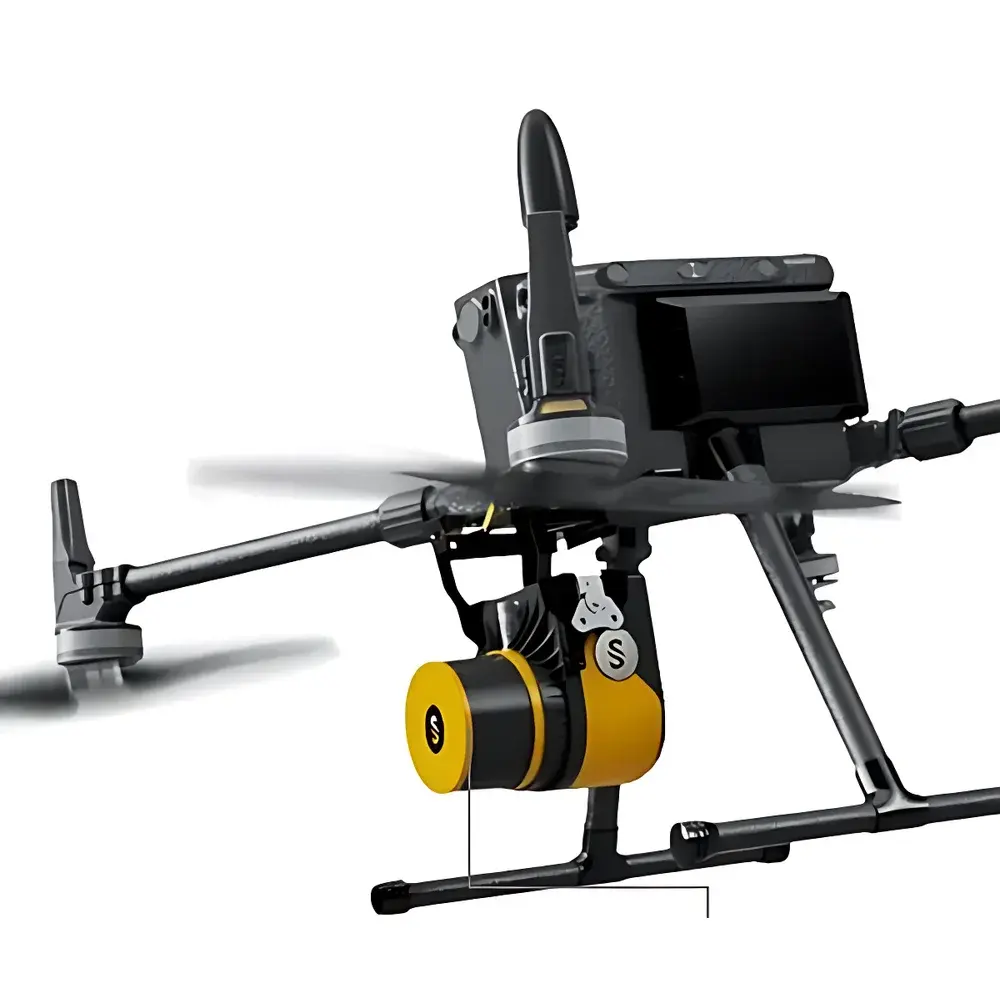
YellowScan Fly&Drive Dual-Mode Mobile LiDAR System
| Origin | Beijing, China |
|---|---|
| Manufacturer Type | Authorized Distributor |
| Origin Category | Domestic (PRC) |
| Model | YellowScan Fly&Drive |
| Pricing | Available Upon Request |
Overview
The YellowScan Fly&Drive is a dual-mode, field-deployable mobile LiDAR system engineered for seamless transition between ground-based vehicle mounting and unmanned aerial vehicle (UAV) integration. It operates on the principle of time-of-flight (ToF) pulsed laser scanning, delivering georeferenced 3D point clouds with centimeter-level spatial accuracy under real-time kinematic (RTK) GNSS correction. The system integrates a high-performance inertial measurement unit (IMU) tightly coupled with a multi-frequency GNSS receiver to maintain robust positioning integrity during dynamic motion—critical for both low-altitude UAV flights and high-speed terrestrial surveys. Designed for operational flexibility rather than platform exclusivity, the Fly&Drive architecture supports rapid reconfiguration without hardware modification, enabling consistent data acquisition across heterogeneous deployment scenarios while preserving geometric fidelity and metadata traceability.
Key Features
- Dual-deployment architecture: Certified for safe, vibration-resistant installation on rotary-wing and fixed-wing UAVs (including DJI Matrice, Freefly Alta, and custom airframes), as well as on SUVs, ATVs, and survey-grade ground vehicles.
- Tightly-coupled GNSS/IMU navigation: Utilizes a dual-antenna RTK-GNSS receiver with 20 Hz output rate and a tactical-grade IMU (0.005°/√hr gyro bias instability) to deliver sub-10 cm horizontal and vertical positional accuracy in post-processed kinematic (PPK) mode.
- Lightweight and power-efficient design: Total system mass < 2.8 kg (excluding batteries); average power draw < 25 W, compatible with standard UAV battery systems and automotive 12–24 V DC supplies.
- High-density scanning performance: 300 kHz maximum scan frequency; 360° horizontal field of view; ±30° vertical FOV; adjustable scan line density up to 2,000 lines per second.
- Onboard synchronization: Hardware-level time synchronization between LiDAR, GNSS, and IMU ensures microsecond-level timestamp alignment, eliminating interpolation artifacts in point cloud generation.
Sample Compatibility & Compliance
The Fly&Drive system is compatible with diverse environmental surface types—including vegetated terrain, bare soil, urban infrastructure, forest canopies, and water-edge interfaces—without requiring retroreflective targets or ground control points (GCPs) for basic georeferencing. Its Class 1 eye-safe laser (905 nm wavelength, < 100 µJ pulse energy) complies with IEC 60825-1:2014 and FDA 21 CFR 1040.10 standards. Data workflows adhere to ISO 19115 metadata conventions and support export formats including LAS/LAZ (ASPRS v1.4), E57, and PLY. For regulated environmental monitoring applications, the system’s onboard logging and PPK processing pipeline meet GLP-aligned data integrity requirements, including full audit trails for sensor configuration, firmware version, and timing calibration logs.
Software & Data Management
Data acquisition and preprocessing are managed via YellowScan’s proprietary SurveyStudio software (v5.2+), which provides real-time point cloud visualization, trajectory quality assessment, and automated boresight calibration. Post-processing leverages industry-standard tools including TerraSolid TerraScan, Global Mapper, and CloudCompare, with native support for PPK workflow integration using GNSS base station RINEX files. All raw sensor logs—including IMU angular rates, GNSS observables, and LiDAR return timing—are preserved in binary format for forensic reproducibility. Exported point clouds include embedded coordinate reference system (CRS) definitions, intensity values, return number flags, and scan angle attributes—essential for vegetation structure analysis (e.g., LAI estimation) and change detection over time series.
Applications
- Topographic mapping and corridor surveying for linear infrastructure (roads, pipelines, transmission lines)
- Forest inventory and biomass estimation using canopy height models (CHM) and voxel-based segmentation
- Urban digital twin development, including building façade extraction and street-level 3D modeling
- Coastal erosion monitoring and floodplain topography update at decimeter-scale resolution
- Agricultural land classification and crop health assessment via multi-temporal point cloud differencing
- Post-disaster rapid assessment of landslide volume, debris flow extent, and structural damage quantification
FAQ
Is the YellowScan Fly&Drive certified for commercial UAV operations in EASA or FAA jurisdictions?
Yes—when integrated with EASA-certified airframes (e.g., Wingcopter 198, Quantum Systems Tron F90+) or FAA Part 107-compliant platforms, the Fly&Drive meets payload safety and electromagnetic compatibility (EMC) requirements per EN 301 489-1 and DO-160G Section 21.
Can the system operate effectively in dense vegetation or under leaf-off conditions?
The 905 nm laser achieves multi-return capability (up to 5 returns per pulse), enabling penetration through partial canopy cover; performance metrics are validated per ASTM E2925-22 for vegetative obstruction characterization.
Does SurveyStudio support automated classification of ground vs. non-ground points?
Yes—integrated algorithms include progressive morphological filtering (PMF) and cloth simulation filtering (CSF), configurable per terrain complexity and point density.
What level of post-processing accuracy can be expected without ground control points?
With PPK processing and a local GNSS base station (< 10 km baseline), horizontal RMSE is typically ≤ 3 cm and vertical RMSE ≤ 5 cm in open-sky conditions, per ISO 19157-2:2021 validation protocols.


