AirPhen Plant Multispectral Imaging System by HI-PHEN
| Origin | France |
|---|---|
| Manufacturer Type | Authorized Distributor |
| Origin Category | Imported |
| Model | AirPhen Plant Multispectral Imaging System |
| Pricing | Available Upon Request |
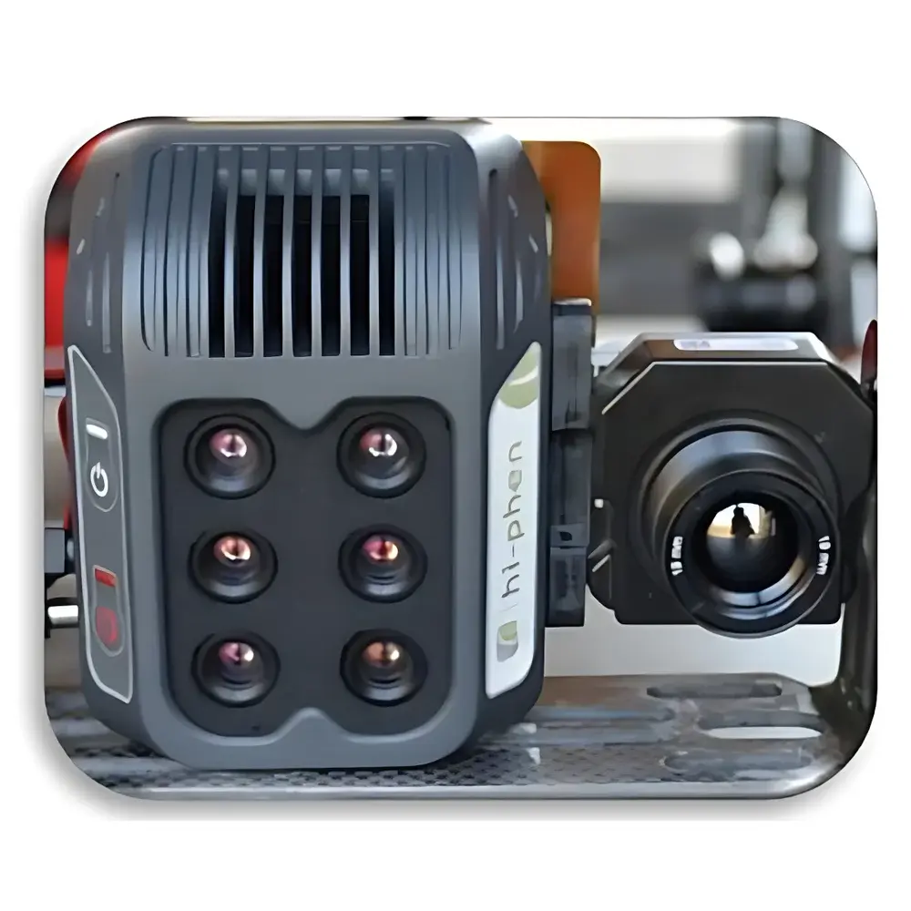
| Sensor Count | 6 synchronized global shutter sensors |
| Image Resolution | 1280 × 960 pixels (12-bit TIFF) |
| Frame Rate | 2 fps |
| Spectral Range | 450–900 nm across 6 configurable bands (standard: 450, 530, 570, 675, 710, 730, 750, 850 nm |
| Lens | Standard 8 mm lens, FOV 33° × 25° |
| at 100 m altitude | 60 m × 40 m coverage, 4.7 cm GSD |
| Integrated GPS | Yes |
| Thermal Imaging Module (optional) | 640 × 512 resolution, 19 mm lens (FOV 32° × 26°), hardware-synchronized shutter |
| Storage | Removable SD card (32 GB included) |
| Power Consumption | 7 W/h |
| Weight | 200 g |
Overview
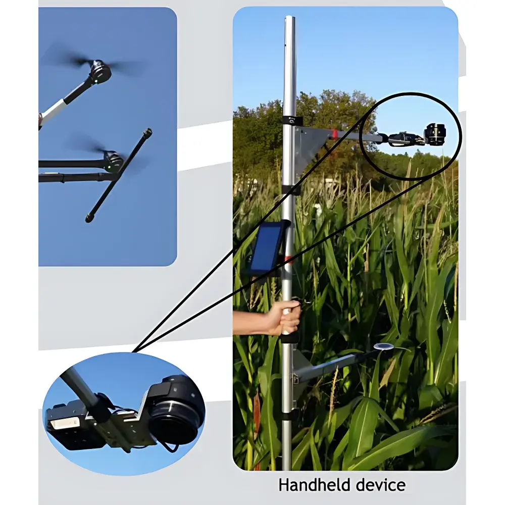
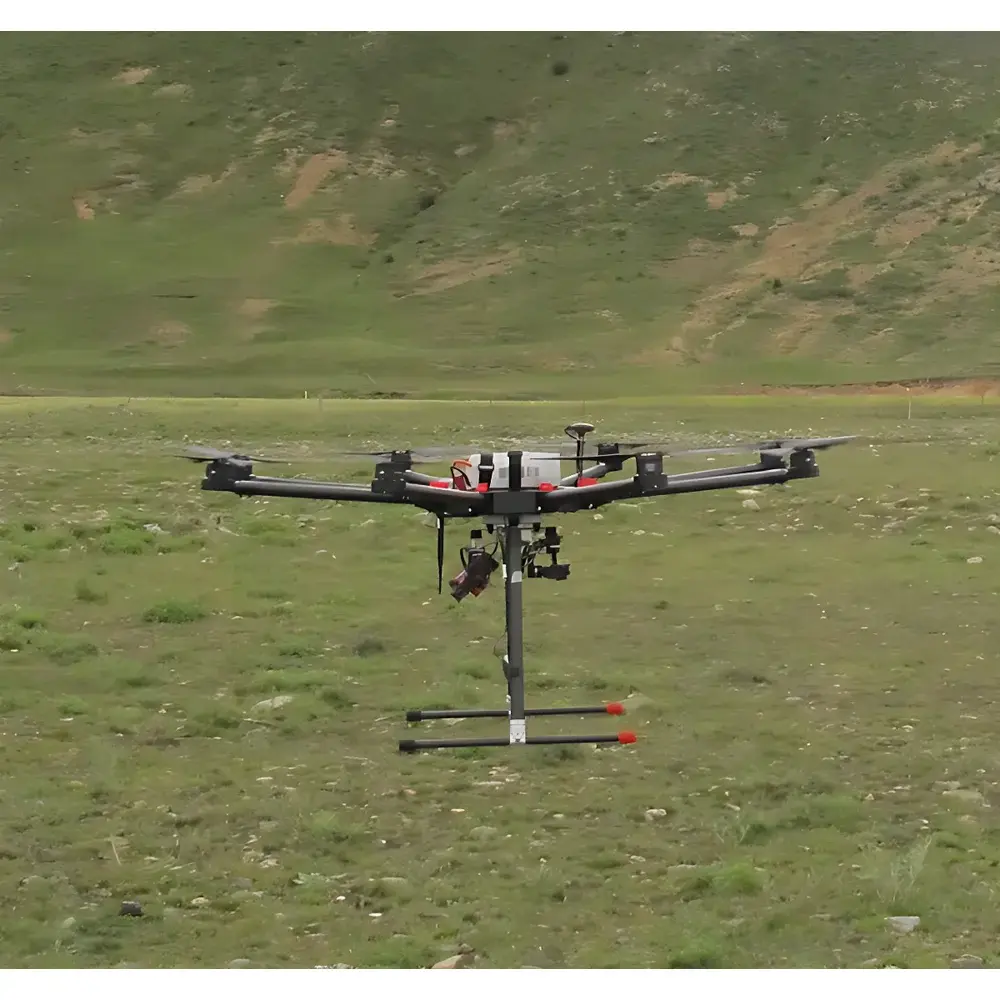
The AirPhen Plant Multispectral Imaging System is a high-precision, field-deployable instrumentation platform engineered by HI-PHEN (France) for quantitative plant phenotyping and ecosystem-level spectral monitoring. Built upon calibrated, synchronized multispectral imaging principles, the system captures reflectance data across six discrete narrowband channels (FWHM ≤ 10 nm) spanning the visible to near-infrared (VNIR) spectrum (450–900 nm). Its optical architecture employs global-shutter CMOS sensors to eliminate motion artifacts during ground-based or UAV-mounted acquisition—ensuring radiometric consistency essential for time-series analysis and cross-platform data harmonization. Unlike broad-band RGB or uncalibrated consumer-grade sensors, AirPhen delivers spectrally resolved, georeferenced imagery traceable to laboratory-grade calibration standards. It supports both proximal sensing (tripod-mounted canopy scanning) and aerial remote sensing when integrated with EcoDrone UAV platforms (UAV-4 or UAV-8), enabling scalable deployment from plot-level validation to landscape-scale vegetation assessment.
Key Features
- Six independently calibrated, global-shutter VNIR sensors operating in parallel—ensuring temporal synchronization critical for dynamic physiological inference.
- Configurable spectral band selection via interchangeable interference filters; standard configuration includes 450 nm (blue), 530 nm (green), 570 nm (yellow), 675 nm (red), 710/730/750 nm (red-edge), and 850 nm (NIR) bands—optimized for derivation of biophysically meaningful vegetation indices.
- Integrated GPS module providing sub-meter geotagging accuracy for spatially explicit phenotypic mapping and GIS integration.
- Modular thermal imaging option: co-aligned 640 × 512 microbolometer sensor with hardware-triggered shutter synchronization—enabling concurrent acquisition of spectral reflectance and surface temperature for stomatal conductance and water stress modeling.
- Low-power embedded architecture (7 W/h) and ultra-lightweight design (200 g) suitable for extended battery-powered operation on multirotor UAVs without payload compromise.
- Onboard SD card storage (32 GB standard) with lossless 12-bit TIFF output—preserving full dynamic range for post-acquisition radiometric correction and index reproducibility.
Sample Compatibility & Compliance
The AirPhen system is validated for non-destructive, in situ measurement of herbaceous and woody plant canopies under natural illumination conditions. It complies with ISO 17025-aligned calibration protocols maintained by HI-PHEN’s metrology lab and supports traceable inter-sensor radiometric normalization using certified reflectance panels (e.g., Spectralon®). Data acquisition workflows are compatible with FAIR (Findable, Accessible, Interoperable, Reusable) data principles. The system meets technical requirements for field phenotyping studies referenced in OECD Test Guidelines (TG 510, TG 511) and supports experimental designs aligned with Crop Ontology and MIAPPE (Minimum Information About a Plant Phenotyping Experiment) reporting standards. No regulatory certification (e.g., FDA, CE medical device) applies, as it is classified as a research-grade environmental sensing instrument.
Software & Data Management
Raw image acquisition is managed via HI-PHEN’s proprietary AirPhen Control Suite (Windows/Linux), which provides real-time preview, exposure optimization, and mission logging with embedded GPS metadata. Post-processing leverages the AirPhen Analysis Toolkit—a Python-based open-architecture framework supporting batch computation of over 30 standardized vegetation indices (NDVI, NDRE, PRI, MCARI, CIrededge, SAVI, EVI, etc.) with optional atmospheric correction (DOS, QUAC). Export formats include GeoTIFF, CSV, and HDF5—ensuring compatibility with QGIS, ENVI, R (raster, phenofit), and Python (xarray, scikit-image) ecosystems. Audit trails, user authentication, and timestamped processing logs satisfy GLP-compliant documentation needs. While not natively Part 11 compliant, the system supports integration into validated LIMS or ELN environments through API-driven data ingestion.
Applications
- High-throughput phenotyping of crop genotypes under controlled field trials—quantifying chlorophyll content, nitrogen status, photosynthetic efficiency, and early stress response (drought, heat, nutrient deficiency).
- Red-edge and NIR band ratio analysis for precision agriculture applications including variable-rate irrigation and fertilizer prescription mapping.
- Long-term ecological monitoring of grassland, forest understory, or wetland vegetation dynamics—supporting carbon flux modeling and biodiversity assessment.
- Validation of satellite-derived vegetation indices (e.g., Sentinel-2 MSI, Landsat OLI) through scale-transfer calibration at the hectare level.
- Integration with eddy-covariance towers or soil moisture networks to establish causal links between spectral signatures and micrometeorological drivers.
FAQ
Is AirPhen suitable for use with fixed-wing or VTOL UAV platforms?
Yes—its low mass, low power draw, and mechanical/electrical interface compatibility (via GPIO and MAVLink support) allow integration with professional fixed-wing and VTOL systems beyond EcoDrone, provided vibration damping and GNSS timing synchronization are implemented.
Can spectral band configurations be customized beyond the standard set?
Yes—HI-PHEN offers factory-installed filter sets targeting specific physiological targets (e.g., 555 nm for carotenoid estimation, 900 nm for water content modeling) with full radiometric recalibration and NIST-traceable documentation.
Does the system provide absolute reflectance values or only relative indices?
When used with a calibrated reference panel and appropriate illumination geometry (e.g., nadir view under diffuse sky conditions), AirPhen enables conversion to surface reflectance using empirical line method (ELM) or dark-object subtraction (DOS), supporting quantitative biophysical parameter retrieval.
What is the recommended calibration frequency for field deployments?
HI-PHEN recommends annual factory recalibration; however, end-users should perform daily radiometric checks using a stable white reference panel prior to each acquisition campaign to ensure inter-day consistency.
Is thermal imaging mandatory or optional?
Thermal imaging is an optional, field-upgradeable module. The base AirPhen system operates exclusively in the VNIR range; thermal capability requires separate hardware integration and firmware activation.
Related Products