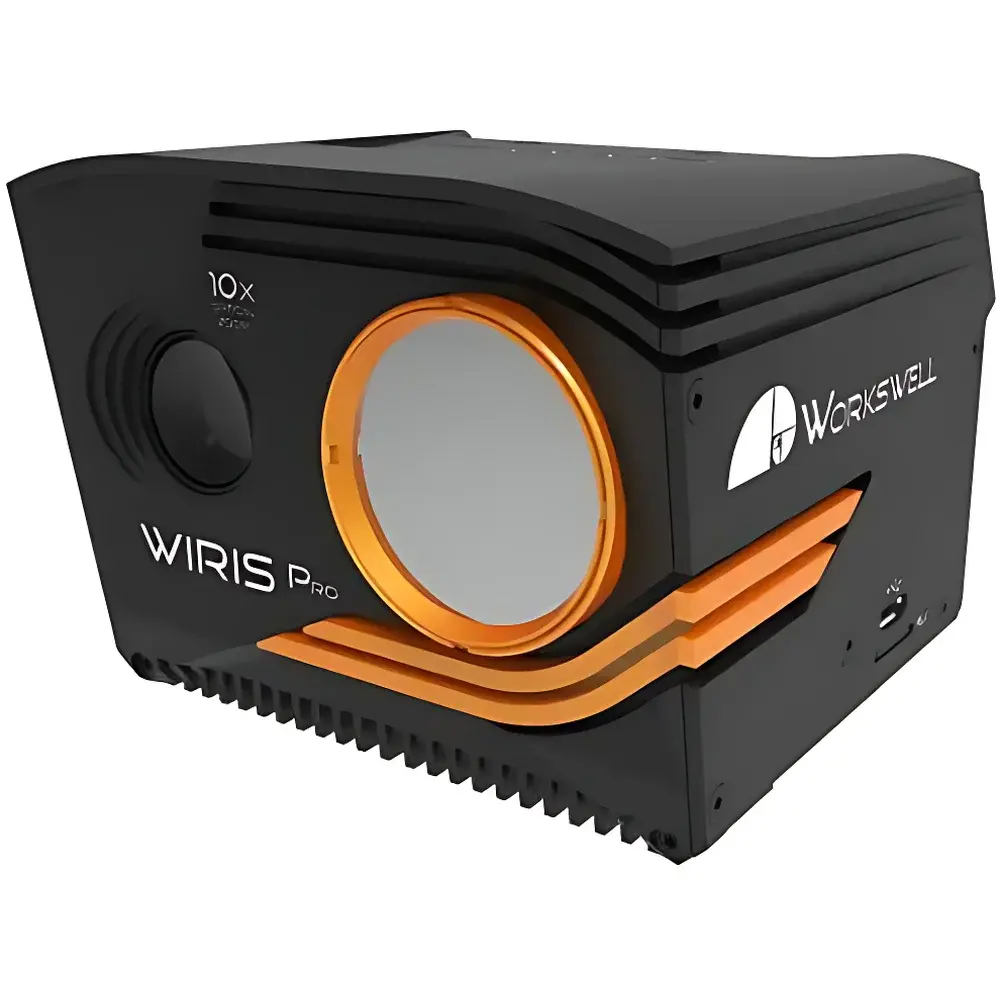
Workswell WIRIS Pro Long-Wave Infrared Thermal Imaging Camera
| Brand | Workswell |
|---|---|
| Origin | Czech Republic |
| Model | WIRIS Pro |
| Detector Type | Uncooled VOx Microbolometer |
| Spectral Range | 7.5–13.5 µm |
| Thermal Resolution | 640 × 512 px |
| Super-Resolution Mode | 1280 × 1024 px (1.3 MP) |
| Frame Rate | 30 Hz |
| Temperature Range | −40 °C to +1500 °C (configurable sub-ranges) |
| Thermal Sensitivity (NETD) | ≤ 0.03 °C @ 30 °C |
| Accuracy | ±2 °C or ±2% of reading |
| Measurement Method | Non-contact radiometric |
| Operating Temperature Range | −20 °C to +55 °C |
| Visible Camera | 1920 × 1080 px, 10× optical zoom with image stabilization |
| Data Storage | Internal 128 GB / 256 GB SSD + microSD + USB flash |
| Interfaces | Ethernet (RJ-45), CAN bus, MAVLink, S.BUS, GPS, TTL trigger, Wi-Fi (low-latency RTSP stream) |
| SDK | MATLAB-compatible Workswell SDK |
| Compliance | CE, RoHS, EN 61000-6-3/-4, ISO 18434-1 (thermographic condition monitoring) |
Overview
The Workswell WIRIS Pro Long-Wave Infrared Thermal Imaging Camera is a dual-spectrum, UAV-optimized radiometric imaging system engineered for high-fidelity thermal measurement in demanding field and industrial environments. Operating within the 7.5–13.5 µm long-wave infrared (LWIR) atmospheric transmission window, the WIRIS Pro employs an uncooled vanadium oxide (VOx) microbolometer focal plane array (FPA) with native resolution of 640 × 512 pixels. Its core measurement principle is based on Planck’s law of blackbody radiation, calibrated against NIST-traceable reference sources to ensure traceable radiometric accuracy across its full operational temperature span (−40 °C to +1500 °C). The camera integrates synchronized visible-light imaging (1920 × 1080 px Full HD) with 10× optically stabilized zoom, enabling precise co-registration of thermal and visual data for pixel-level spatial correlation. Designed from inception for aerial deployment, it meets stringent mechanical, thermal, and electromagnetic requirements for integration into fixed-wing and multirotor unmanned platforms—while maintaining full functionality in ground-based stationary or handheld configurations.
Key Features
- True radiometric calibration: Each unit ships with an individual factory calibration certificate compliant with ISO/IEC 17025 practices; calibration traceable to primary standards.
- Super-resolution imaging: On-device computational upscaling delivers 1280 × 1024 px thermal imagery (1.3 MP) without interpolation artifacts, enhancing spatial detail for quantitative analysis.
- Dual-spectrum synchronization: Simultaneous capture of radiometric LWIR and Full HD visible frames at identical timestamps, supporting automated fusion workflows in photogrammetry software (Pix4D, Agisoft Metashape).
- Robust mechanical architecture: CNC-machined aluminum housing (mass < 450 g), IP54-rated ingress protection, and interchangeable germanium lens protectors ensure reliability in harsh outdoor conditions.
- Multi-interface real-time control: Native support for MAVLink, CAN bus (DJI A3/M600 compatible), S.BUS, Ethernet, and TTL triggering enables deterministic command-and-control in safety-critical UAV telemetry loops.
- Onboard WIRIS OS: Real-time embedded operating system enabling in-flight parameter adjustment, region-of-interest (ROI) analytics, alarm thresholds (above/below/between), and non-uniformity correction (NUC) scheduling.
- Secure data integrity: Triple redundant storage—internal high-speed SSD (128/256 GB), microSD slot, and USB host port—ensures lossless recording of raw radiometric TIFF, JPEG, and H.264 video streams with embedded GPS geotags.
Sample Compatibility & Compliance
The WIRIS Pro is designed for non-contact surface temperature measurement of heterogeneous, dynamic, and spatially extended targets—including vegetation canopies, photovoltaic arrays, electrical substations, building envelopes, and wildlife subjects. Its spectral response minimizes solar reflectance interference, making it suitable for daytime operation without shutter-induced artifacts. The system complies with ISO 18434-1 for thermographic condition monitoring, EN 61000-6-3 (emissions) and EN 61000-6-4 (immunity), and carries CE and RoHS declarations. Radiometric output adheres to ASTM E1933-19 guidelines for infrared thermography data reporting. While not FDA-regulated, its calibration methodology satisfies GLP-aligned documentation requirements for environmental and industrial QA/QC applications subject to internal audit.
Software & Data Management
Workswell provides a cross-platform desktop application (Windows/macOS) supporting radiometric post-processing, emissivity correction, atmospheric compensation (humidity, distance, ambient temperature), and report generation in PDF/HTML formats. Raw thermal data is stored in standard-compliant TIFF format containing embedded metadata (radiometric coefficients, lens parameters, GPS coordinates, UTC timestamps). The MATLAB-compatible SDK grants low-level access to sensor registers, frame buffers, and real-time control registers—enabling custom algorithm development for machine vision, anomaly detection, or closed-loop thermal feedback systems. All firmware updates, configuration profiles, and georeferenced mission logs are managed via encrypted HTTP(S) endpoints. Video streams conform to RTSP v2.0 over IPv4/IPv6 and support H.264 baseline profile decoding at 30 fps with sub-100 ms end-to-end latency.
Applications
- Precision agriculture: Canopy temperature mapping for drought stress assessment, irrigation optimization, and yield prediction using crop water stress index (CWSI) models.
- Renewable energy inspection: Thermographic survey of PV modules (hot-spot detection per IEC 62446-1), wind turbine gearboxes, and solar thermal collectors.
- Electrical infrastructure monitoring: Live-line detection of loose connections, overloaded breakers, and transformer hotspots under load.
- Environmental science: Surface temperature profiling of wetlands, coastal zones, and volcanic terrain; thermal plume tracking in marine ecosystems.
- Search and rescue (SAR): Human/animal detection in low-visibility conditions (smoke, fog, darkness) leveraging high NETD (<30 mK) and wide dynamic range.
- Industrial predictive maintenance: Bearing temperature trending, refractory lining erosion assessment in kilns/furnaces, and insulation integrity verification.
- Archaeological prospection: Subsurface feature detection via diurnal thermal inertia differentials in soil stratigraphy.
FAQ
Is the WIRIS Pro certified for use on commercial UAVs in EASA or FAA jurisdictions?
Yes—the device meets CE marking requirements for airborne electronic equipment and has been integrated into certified UAS platforms under EASA SORA and FAA Part 107 operational frameworks. Integration validation reports are available under NDA.
Can radiometric data be exported in formats compatible with GIS platforms?
Yes—geotagged thermal TIFFs contain EXIF-compliant GPS tags and can be ingested directly into QGIS, ArcGIS, and ENVI. Coordinate referencing follows WGS84 datum with sub-meter positional accuracy when paired with RTK-GPS.
Does the camera support external time synchronization (e.g., PPS or IEEE 1588)?
No—time synchronization is achieved via GPS PPS input through the 10-pin digital interface; IEEE 1588 is not implemented.
What is the minimum measurable temperature difference at 1000 °C?
At target temperatures above 500 °C, NETD degrades to ≤ 0.15 °C due to photon noise dominance; the specified 0.03 °C sensitivity applies at ambient and moderate temperatures (20–100 °C).
Are lens calibrations performed individually per unit and per focal length?
Yes—each interchangeable lens (18°, 32°, 45°, 69° FOV) undergoes separate factory calibration; calibration coefficients are embedded in firmware and auto-loaded upon lens recognition.