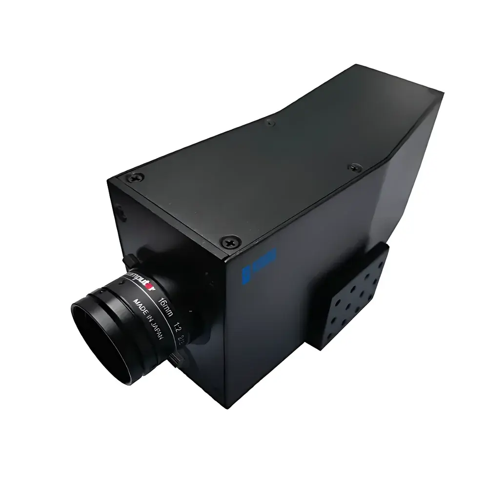
SAIL HERO XHGGP-90A Airborne Pushbroom Hyperspectral Imaging System for Water Quality Remote Sensing
| Brand | SAIL HERO |
|---|---|
| Origin | Hebei, China |
| Manufacturer Type | Original Equipment Manufacturer (OEM) |
| Country of Origin | China |
| Model | XHGGP-90A |
| Operating Principle | Pushbroom Scanning |
| Imaging Method | Dispersive (Prism-Grating Hybrid) |
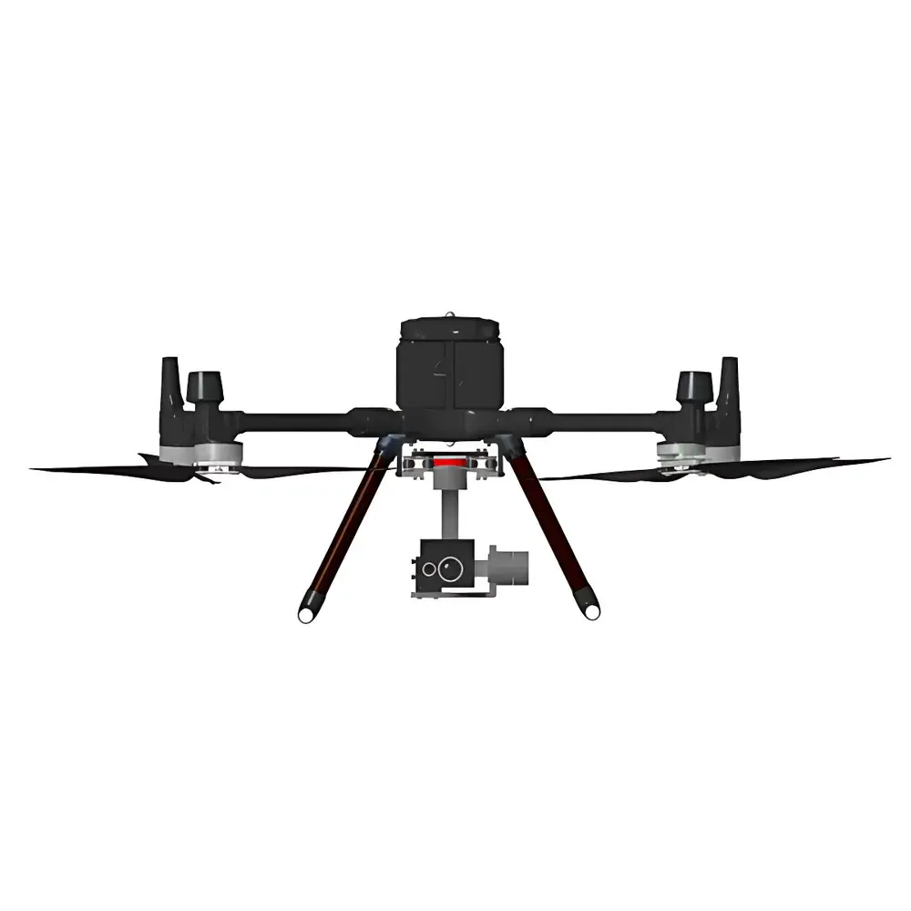
| Platform | UAV-Mounted |
| Spectral Range | 400–1000 nm |
| Spectral Resolution | ≤2 nm FWHM @ 546.1 nm |
| Spatial Resolution (IFOV) | 0.1 m at 300 m AGL |
| Image Resolution | 1000 × 1200 pixels |
| Total Field of View (TFOV) | ≥20° |
| Max Operational Altitude | 500 m AGL |
| Onboard Power | Integrated LiPo Battery with Extended Flight Duration |
| Environmental Certification | Certified by China National Environmental Monitoring Centre (CNEMC) and China Environmental Protection Industry Association (CEPIA) |
| Data Processing | End-to-end pipeline including radiometric calibration, atmospheric correction, spectral unmixing, and empirical/semi-analytical inversion algorithms for water quality parameters |
Overview
The SAIL HERO XHGGP-90A is a purpose-built airborne pushbroom hyperspectral imaging system engineered for high-fidelity, large-area remote sensing of inland and coastal water bodies. It operates on the principle of spatial-spectral scanning: as the UAV advances along its flight path, the sensor acquires contiguous spectral bands across the visible to near-infrared (VNIR) spectrum (400–1000 nm) line-by-line, generating a three-dimensional data cube (x, y, λ). Each pixel contains a full reflectance spectrum, enabling quantitative retrieval of optically active constituents in water. Unlike broadband multispectral sensors, this dispersive (prism-grating hybrid) architecture delivers ≤2 nm spectral resolution at 546.1 nm—sufficient to resolve narrow absorption features of chlorophyll-a, dissolved organic matter (CDOM), suspended solids, and nitrate-related transitions. The system is calibrated traceably to NIST-traceable standards and supports radiometric, geometric, and atmospheric correction workflows compliant with ISO 17025–accredited laboratory practices.
Key Features
- Pushbroom acquisition architecture ensures high signal-to-noise ratio (SNR) and minimal motion-induced spectral distortion during UAV flight.
- Dispersive optical design with dual-stage spectral separation achieves consistent ≤2 nm FWHM resolution across the full 400–1000 nm range, validated at multiple wavelength reference points.
- Native spatial sampling of 0.1 m IFOV at 300 m altitude enables sub-meter detection of localized pollution plumes, algal bloom boundaries, and sediment-laden inflow zones.
- Integrated thermal stabilization subsystem maintains optical alignment and detector response stability under variable ambient conditions—no external cooling or vibration-isolation infrastructure required.
- Autonomous flight integration includes pre-programmed grid missions, real-time telemetry feedback, automatic return-to-home (RTH), and fail-safe data buffering upon link loss.
- Modular payload interface supports synchronized co-registration with auxiliary sensors: RGB video streams, meteorological modules (temperature, humidity, wind speed), and GNSS-IMU units with RTK-grade positioning (≤2 cm horizontal accuracy).
Sample Compatibility & Compliance
The XHGGP-90A is designed exclusively for non-contact, wide-area surface water assessment. It does not require in situ sampling or physical interaction with the target medium. Its measurement domain includes natural and anthropogenically influenced freshwater systems (rivers, lakes, reservoirs), estuarine environments, and shallow coastal zones (<5 m depth). All spectral inversion models are developed and validated against field-collected water samples analyzed per standard methods (e.g., ISO 8692 for chlorophyll-a, ISO 7027 for turbidity, APHA 5210B for COD, EPA 365.3 for total phosphorus). The system complies with CNEMC Technical Specification HJ 1138–2020 for airborne hyperspectral water quality monitoring equipment and meets CEPIA certification requirements for environmental instrumentation used in statutory monitoring programs.
Software & Data Management
Data acquisition, preprocessing, and parameter inversion are executed through SAIL HERO’s proprietary HyWater Analytics Suite—a Windows-based application supporting batch processing, version-controlled algorithm libraries, and audit-trail logging. Core modules include: (1) Raw data ingestion with embedded GPS/IMU metadata; (2) Radiometric calibration using onboard dark-current and white-reference frames; (3) Atmospheric correction via QUAC (Quick Atmospheric Correction) or MODTRAN-based look-up tables; (4) Pixel-level spectral unmixing and endmember selection; (5) Parameter retrieval using ensemble-trained regression models (PLSR, RF, and hybrid physics-informed neural networks) for ≥15 water quality variables—including TSS, Secchi depth, Chl-a, CODMn, DOC, CDOM, TN, TP, NH3-N, Zn, Cu, Pb, DO, and bathymetric estimation. All outputs are exportable in GeoTIFF, ENVI, and CSV formats with embedded CRS metadata. The software supports FDA 21 CFR Part 11–compliant user access control, electronic signatures, and immutable audit logs for GLP/GMP-aligned operations.
Applications
- River basin-scale eutrophication mapping and longitudinal nutrient load tracking.
- Reservoir stratification monitoring and early-warning detection of cyanobacterial blooms.
- Coastal zone management: identification of terrigenous sediment plumes, sewage outfall dispersion, and coral reef health indicators.
- Regulatory compliance reporting for national surface water quality assessment programs (e.g., China’s “Blue Sky & Clear Water” initiative).
- Post-event analysis following floods or industrial spills—quantifying spatial extent, concentration gradients, and temporal evolution of contaminants.
- Cross-platform validation of satellite-derived water quality products (e.g., Sentinel-2, Landsat 9) at sub-field scale.
FAQ
What spectral calibration standards are used during factory verification?
Factory calibration employs NIST-traceable tungsten-halogen and deuterium lamps, with wavelength accuracy verified against atomic emission lines (Hg, Ne, Ar) and spectral bandwidth confirmed using monochromatic laser sources.
Is atmospheric correction mandatory before parameter inversion?
Yes—empirical inversion models assume top-of-water reflectance. Uncorrected at-sensor radiance introduces systematic bias, especially in humid or hazy conditions; QUAC or MODTRAN-based correction is embedded in all standard processing pipelines.
Can the system operate under partial cloud cover?
It can acquire usable data under scattered clouds, but persistent overcast or heavy haze degrades SNR and increases uncertainty in CDOM and Chl-a retrievals; mission planning tools recommend solar zenith angles <60° and cloud cover <30% for optimal results.
How are inversion algorithms validated for regulatory use?
All algorithms undergo independent validation using >500 paired field samples collected across diverse water types (eutrophic, dystrophic, turbid, oligotrophic) and are subject to annual inter-laboratory comparison per HJ 1138–2020 Annex C.
Does the system support real-time downlink of spectral cubes?
No—raw hyperspectral data (typically 1.2–2.1 GB per 10-min flight) is stored onboard due to bandwidth constraints; processed georeferenced maps and statistical summaries may be transmitted via LTE telemetry during flight.
Related Products