ZYJY-DZ02 Artificial Rainfall Simulation System
| Brand | ZYKX |
|---|---|
| Origin | Beijing, China |
| Manufacturer Type | Authorized Distributor |
| Country of Origin | China |
| Model | ZYJY-DZ02 |
| Instrument Category | Soil Moisture / Matric Potential Analyzer |
| Rainfall Intensity Range | 20–200 mm/h |
| Rainfall Uniformity Coefficient | >0.85 |
| Rainfall Regulation Accuracy | ±6 mm/h |
| Response Time for Intensity Adjustment | <30 s |
| Rain Gauge Orifice Diameter | Φ200 ± 0.6 mm |
| Rain Gauge Resolution | 0.1 mm |
| Controller Supply Voltage | AC 220 V, 50 Hz |
| Operating Temperature | 0–60 °C |
| Operating Relative Humidity | ≤95% RH |
| Data Logger Storage Capacity | Unlimited (SD card or internal flash) |
| Sampling Interval | ≥3 s (configurable) |
| Nozzle Types | Three interchangeable nozzles (9 mm, 11 mm, 13 mm diameter) |
| Spray Angle | 45° |
| Redundant Hydraulic Architecture | Yes |
Overview
The ZYKX ZYJY-DZ02 Artificial Rainfall Simulation System is a precision-engineered, laboratory- and field-deployable hydrological simulation platform designed to replicate natural rainfall conditions under controlled experimental settings. Based on the principle of pressurized nozzle-based droplet generation and closed-loop hydraulic feedback control, the system enables quantitative, repeatable, and spatially uniform water application across variable plot dimensions. It is specifically developed for fundamental and applied research in soil hydrology, erosion mechanics, infiltration dynamics, eco-hydrological coupling, and civil engineering hydraulics. Unlike empirical sprinkler setups, the ZYJY-DZ02 integrates real-time pressure modulation, multi-nozzle selection logic, and adaptive flow compensation—ensuring consistent raindrop size distribution (DSD), kinetic energy delivery, and temporal intensity fidelity across its operational range of 20–200 mm/h. Its modular architecture supports both bench-scale lysimeter studies and large-area runoff plots, making it suitable for ISO/IEC 17025-accredited environmental testing laboratories and long-term monitoring sites compliant with ASTM D3385 (Standard Test Method for Infiltration Rate of Soils in Field Using Double-Ring Infiltrometer) and USDA-NRCS technical specifications.
Key Features
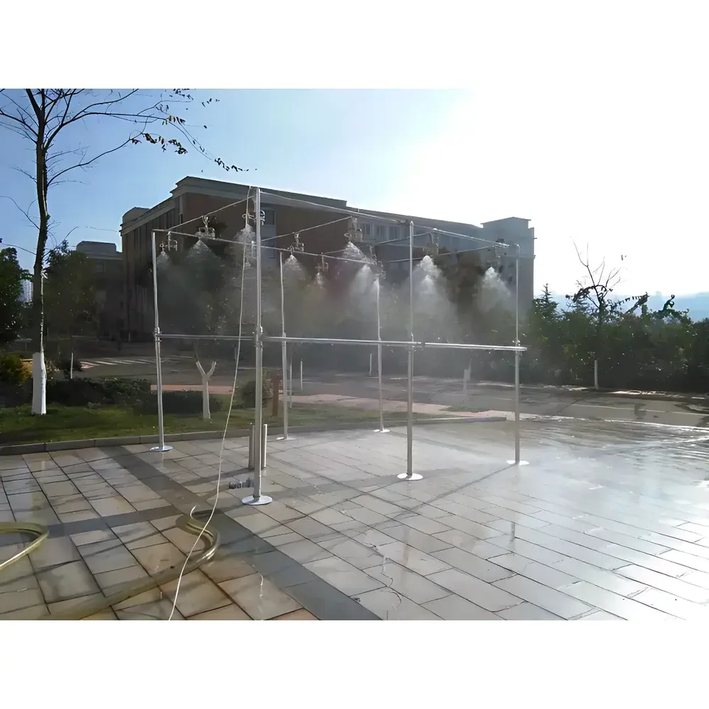
- Three interchangeable stainless-steel nozzles (9 mm, 11 mm, 13 mm orifice diameters) enabling scalable coverage (2.1–3.5 m radius per nozzle) and adjustable kinetic energy profiles.
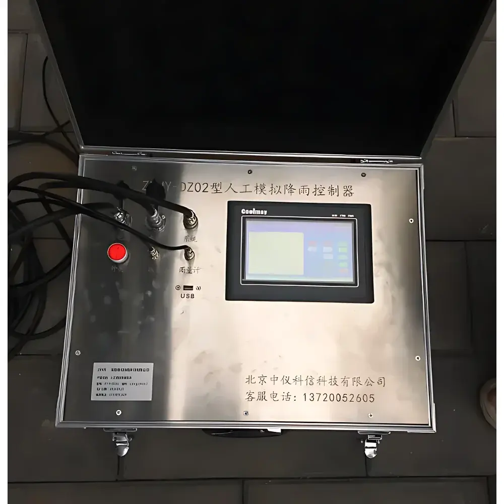
- PLC-based closed-loop control system with integrated pressure transducers, flow meters, and solenoid valve arrays—minimizing hysteresis and compensating for pipeline inertia during rapid rain intensity transitions (<30 s response time).
- Touchscreen HMI interface with embedded data logging; supports CSV export and optional RS-485/Modbus TCP connectivity for integration into SCADA or LIMS environments.
- Dual-redundant hydraulic subsystem: independent pump circuits and backup pressure regulators ensure uninterrupted operation during maintenance or component failure—critical for multi-day continuous experiments.
- High-fidelity rain gauge (Φ200 mm orifice, 0.1 mm resolution) calibrated per ISO 9564:2019 for precipitation measurement accuracy and traceability.
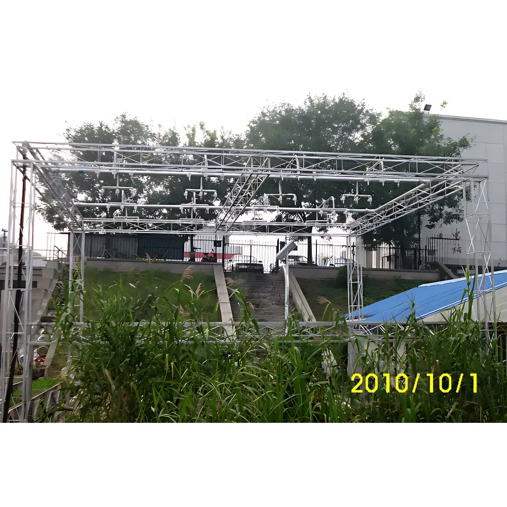
- Customizable mounting frame and height-adjustable support structure to accommodate variable plot topography and vegetation canopy clearance requirements.
Sample Compatibility & Compliance
The ZYJY-DZ02 accommodates heterogeneous substrates including bare soil, vegetated plots, engineered geotextiles, compacted clay liners, and biochar-amended media. Its non-invasive, overhead delivery design avoids surface disturbance prior to infiltration onset—preserving natural soil crust integrity and initial moisture gradients. The system complies with GLP-aligned data integrity requirements: all rainfall events are timestamped, parameterized (intensity, duration, cumulative volume), and stored with audit-trail metadata. Rainfall uniformity (>0.85 coefficient per Christiansen index) is validated using grid-based tipping-bucket array measurements prior to each experimental campaign—meeting criteria outlined in FAO Irrigation and Drainage Paper No. 56 and CNAS-CL01:2018 for environmental test method validation.
Software & Data Management
The embedded controller firmware provides local configuration of rainfall protocols—including ramped intensity profiles, pulsed rainfall sequences, and multi-stage storm simulations. Raw sensor data (pressure, flow rate, accumulated volume, ambient temperature/humidity) are logged at user-defined intervals (≥3 s) onto removable SD storage with cyclic overwrite protection. Optional PC software (Windows/Linux compatible) enables remote monitoring via Ethernet/Wi-Fi, batch calibration curve import, and automated report generation aligned with USGS Water Resources Mission Area reporting templates. All exported datasets include ISO 8601 timestamps, instrument serial identifiers, and environmental context tags—facilitating FAIR (Findable, Accessible, Interoperable, Reusable) data practices required by NSF, NERC, and Horizon Europe grant mandates.
Applications
- Quantification of soil detachment rates and sediment yield under varying rainfall intensities (USDA-Water Erosion Prediction Project inputs).
- Infiltration capacity mapping for green infrastructure performance assessment (e.g., bioswales, permeable pavements).
- Root-zone water redistribution studies in agroecosystems under climate-resilient irrigation scenarios.
- Validation of numerical models (e.g., HYDRUS-2D, WEPP, SWAT) requiring boundary condition fidelity.
- Evaluation of erosion control measures (mulches, geogrids, hydroseeding) under standardized rainfall stressors.
- Soil–structure interaction analysis for slope stability modeling in civil engineering contexts.
FAQ
What is the minimum and maximum controllable rainfall intensity?
The system delivers calibrated intensities from 20 mm/h to 200 mm/h, with optional extended-range configurations available upon request.
Can the system operate autonomously for unattended multi-day experiments?
Yes—the integrated data logger supports continuous operation for >30 days on standard power supply, with battery backup capability for field deployments.
Is the rainfall uniformity validated per international standards?
Uniformity is assessed using a 5×5 tipping-bucket grid per ASTM D3385 Annex A2 methodology, with reports provided for each system commissioning.
Does the system support integration with third-party soil moisture or runoff sensors?
Yes—via analog 4–20 mA or digital Modbus RTU interfaces, enabling synchronized acquisition across distributed sensor networks.
What maintenance protocols are recommended for long-term reliability?
Quarterly nozzle inspection and ultrasonic cleaning, annual pressure transducer recalibration, and biannual verification of rain gauge orifice geometry per ISO 9564.
Related Products


