CE318 Automated Sun Photometer by FPI
| Brand | FPI |
|---|---|
| Origin | Zhejiang, China |
| Manufacturer Type | OEM Manufacturer |
| Country of Origin | China |
| Model | CE318 |
| Pricing | Available Upon Request |
Overview
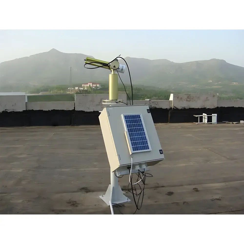
The CE318 Automated Sun Photometer, engineered by FPI (Focus Photonics Inc.), is a field-deployable, high-precision radiometric instrument designed for continuous, autonomous measurement of direct solar irradiance and sky radiance across multiple narrow spectral bands. Operating on the principle of extinction photometry, the CE318 quantifies atmospheric optical depth by measuring attenuation of sunlight at discrete wavelengths (typically 340, 380, 440, 500, 675, 870, 936, 1020, and 1640 nm), enabling derivation of aerosol optical thickness (AOT), Ångström exponent, water vapor column, and fine/coarse mode particle ratios. Its dual-axis sun-tracking architecture—combining time-based coarse pointing with closed-loop feedback from a quadrant photodetector—ensures tracking accuracy better than ±0.1° under variable sky conditions. The system is optimized for long-term unattended operation in remote or harsh environments, supporting critical observational networks such as AERONET (AErosol RObotic NETwork), GAW (Global Atmosphere Watch), and regional air quality monitoring infrastructures.
Key Features
- Autonomous dual-axis solar tracking: integrated stepper motor system with azimuth and elevation degrees of freedom, controlled via real-time solar ephemeris algorithms and refined using a four-quadrant silicon photodiode detector for sub-arcminute pointing stability
- Solar-powered operation: modular photovoltaic panel and deep-cycle battery system enables continuous data acquisition without grid dependency; power management firmware extends operational uptime during extended cloud cover or low-light periods
- Environmental resilience: IP65-rated enclosure with marine-grade aluminum alloy housing and corrosion-resistant anodized finish; enhanced lightning protection compliant with IEC 61643-11 surge immunity standards
- Intelligent environmental sensing: built-in capacitive humidity sensor triggers automatic instrument shutdown upon precipitation detection, safeguarding optical surfaces and minimizing maintenance intervals
- Optical protection protocol: control unit executes scheduled park-and-cover sequences during non-operational hours or adverse weather, reducing dust accumulation and thermal stress on interference filters and detectors
- Modular calibration interface: supports traceable NIST- or PTB-aligned calibration via removable filter wheel and reference lamp assembly; factory calibration certificates include uncertainty budgets per ISO/IEC 17025 requirements
Sample Compatibility & Compliance
The CE318 is designed for open-sky atmospheric column measurements and requires unobstructed hemispherical view (≥120° zenith angle clearance). It operates within ambient temperature ranges of −30 °C to +50 °C and relative humidity up to 95% non-condensing. Instrument design and data processing workflows align with internationally recognized protocols: AERONET Level 1.5 and Level 2.0 inversion algorithms; ISO 9223 corrosion classification (C5-M); and WMO/GAW Best Practice Guidance for Aerosol Optical Depth Measurements. Data output formats comply with CF-netCDF v1.6 conventions and support ingestion into EPA AirNow, EEA Air Quality e-Reporting, and Copernicus Atmosphere Monitoring Service (CAMS) pipelines.
Software & Data Management
The CE318 integrates with FPI’s proprietary “SunView” software suite (v4.2+), which provides real-time telemetry monitoring, remote firmware updates, and automated QA/QC flagging based on solar zenith angle, signal-to-noise ratio, and cloud screening heuristics. Raw voltage counts are converted to calibrated radiance using factory-determined responsivity coefficients and temperature-compensated dark current subtraction. All measurement metadata—including GPS coordinates, local time stamp (UTC synchronized via NTP), instrument status flags, and environmental sensor readings—are embedded in each data packet. Audit trails, user access logs, and electronic signatures meet GLP-compliant recordkeeping standards; optional 21 CFR Part 11 add-on module enables FDA-regulated deployment in environmental health assessment contexts.
Applications
- Long-term climate trend analysis: multi-decadal AOT time series for detecting anthropogenic aerosol forcing and validating CMIP6 model outputs
- Regional haze characterization: source apportionment of biomass burning, mineral dust, and urban pollution plumes via spectral deconvolution and Mie scattering inversions
- Satellite validation: vicarious calibration of MODIS, VIIRS, Sentinel-3 OLCI, and GOCI sensors through simultaneous nadir overpasses and spatial collocation protocols
- Atmospheric correction: input parameter generation for L2/L3 land surface reflectance retrieval in hyperspectral and multispectral remote sensing
- Public health exposure modeling: correlation of fine-mode AOT with PM2.5 ground-level concentrations for epidemiological cohort studies
- Renewable energy forecasting: input to clear-sky irradiance models used in solar farm yield optimization and grid integration planning
FAQ
What spectral channels does the CE318 support, and are custom configurations available?
The standard CE318 includes nine fixed-band interference filters (340, 380, 440, 500, 675, 870, 936, 1020, and 1640 nm). Custom filter sets—including UV-B enhancement or polarization-sensitive channels—can be configured upon request and validated per ISO 12232 Annex D procedures.
Is the CE318 compatible with AERONET data submission protocols?
Yes—the instrument meets AERONET hardware certification requirements and exports Level 1.0 data in standard ASCII format; Level 2.0 inversion requires co-location with a CIMEL CE-318 or equivalent and use of AERONET’s official inversion codebase.
How is calibration traceability maintained over field deployment cycles?
Each unit ships with a NIST-traceable calibration certificate; biannual field recalibration is recommended using portable integrating sphere sources or Langley plot methodology at high-altitude sites.
Can the CE318 operate in fully autonomous mode without cellular or satellite connectivity?
Yes—local SD card logging (up to 16 GB) ensures uninterrupted data capture; optional LTE or Iridium modem modules enable near-real-time transmission when connectivity is available.
Does the system support synchronized sky radiance scans (e.g., almucantar or principal plane scans)?
Yes—SunView software enables programmable sky scan routines for angular distribution mapping; scan resolution and step size are configurable to match specific inversion algorithm requirements (e.g., GRASP or OPAC).