Atmos Fixed-Wing UAV Remote Sensing System
| Origin | Spain |
|---|---|
| Manufacturer Type | Authorized Distributor |
| Origin Category | Imported |
| Model | Atmos |
| Pricing | Upon Request |
Overview
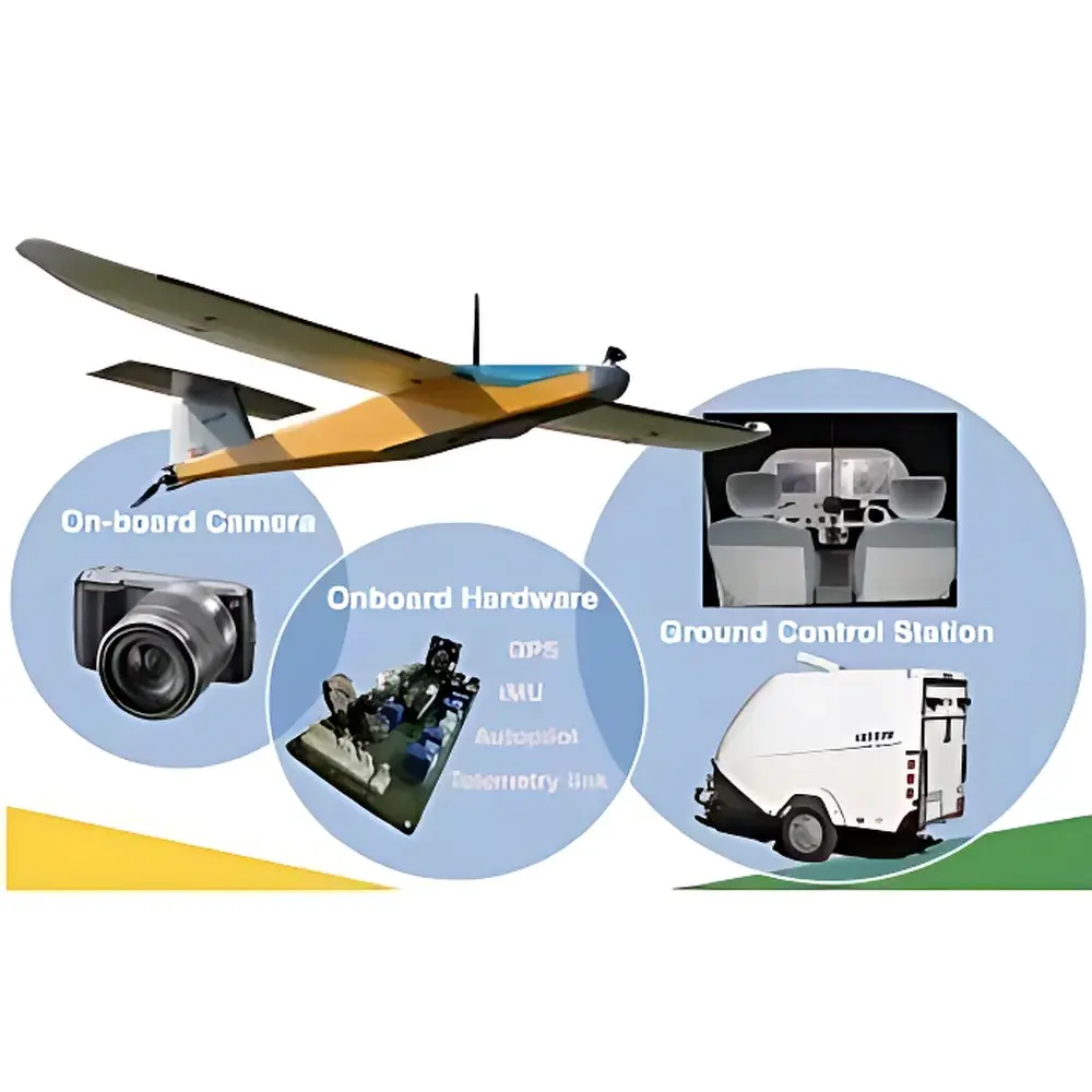
The Atmos Fixed-Wing UAV Remote Sensing System is a turnkey, hand-launched, lightweight fixed-wing unmanned aerial platform engineered for high-efficiency ecological and environmental remote sensing. Designed and assembled in Europe, the system integrates precision aerodynamics, autonomous flight control, and modular multispectral/hyperspectral imaging capabilities to deliver scientifically rigorous, repeatable, and georeferenced Earth observation data. Its core measurement principle relies on passive optical remote sensing—capturing reflected solar radiation across visible, near-infrared (NIR), red-edge, shortwave infrared (SWIR), and thermal infrared spectral domains—to derive biophysical and biochemical parameters such as NDVI, LAI, chlorophyll content, surface temperature, and land-cover classification. The platform is purpose-built for operational deployment in field-based environmental monitoring programs requiring consistent spatial coverage, sub-decimeter ground sampling distance (GSD), and compliance with standard photogrammetric and radiometric workflows.
Key Features
- Lightweight airframe with maximum takeoff weight (MTOW) of 2.9 kg and payload capacity up to 900 g—optimized for extended endurance and low-noise operation in sensitive ecological zones.
- Autonomous flight capability enabled by 3DRobotics-based autopilot firmware, supporting pre-programmed mission planning, real-time telemetry, and fail-safe recovery protocols including deep-stall landing or parachute deployment.
- Cruise speed of 50–60 km/h and maximum speed of 105 km/h, with wind resistance up to 30 km/h—ensuring stable acquisition under typical field conditions.
- Modular sensor bay accommodating up to two simultaneously mounted optical payloads: interchangeable combinations include RGB + multispectral, RGB + hyperspectral, or RGB + thermal infrared configurations.
- Integrated ground control station (GCS) with intuitive mission planning interface—supporting precise definition of flight altitude, image overlap (front/side lap), ground sampling distance (GSD), and area-of-interest (AOI) coverage.
- Standard 20 MP RGB camera featuring Exmor APS HD CMOS sensor (APS-C format), 5456 × 3632 pixel resolution, and embedded GPS/IMU for direct geotagging of imagery.
Sample Compatibility & Compliance
The Atmos system supports a broad range of spectral sensor modules compatible with standard radiometric calibration protocols and widely adopted environmental monitoring frameworks. Multispectral sensors capture five discrete bands (blue, green, red, red-edge, NIR) at 12-bit RAW depth with geo-referenced output stored on SD cards. Hyperspectral modules operate in snapshot mode with no interpolation, delivering true 1010 × 1010 pixel frames across up to 380 spectral channels (FWHM = 10 nm) within user-selectable ranges (e.g., 500–900 nm). Thermal infrared modules provide calibrated radiometric data at 640 × 512 resolution (7.5–13.5 µm). All acquired datasets are structured to align with ISO 19115 metadata standards and support integration into GIS platforms compliant with OGC WMS/WFS specifications. The system is routinely deployed in projects adhering to EU INSPIRE directives, USGS/NASA Landsat-derived validation protocols, and FAO-recommended methodologies for agricultural and forest monitoring.
Software & Data Management
Flight planning, telemetry monitoring, and post-mission data ingestion are managed through an open-architecture GCS software suite compatible with Windows OS and exportable to industry-standard formats (GeoTIFF, ENVI .hdr, CSV, KML). Raw sensor data undergoes radiometric correction using onboard calibration references and optional reflectance panels. Orthomosaic generation, point cloud derivation, and spectral index computation (e.g., NDVI, NDRE, NDWI, SAVI) are supported via bundled photogrammetry tools compatible with Agisoft Metashape and Pix4Dmapper. For regulatory traceability, audit logs record flight parameters, sensor configuration, timestamped GPS coordinates, and operator identity—enabling alignment with GLP-compliant documentation requirements. Exported datasets retain EXIF and XMP metadata fields required for long-term archival under ISO 16363 digital preservation standards.
Applications
- Agricultural monitoring: Crop health assessment, yield prediction, irrigation scheduling, and pest/disease early detection via spectral vegetation indices.
- Forestry management: Canopy structure analysis, species mapping, fire risk assessment, post-fire regeneration tracking, and illegal logging surveillance.
- Wetland and biodiversity monitoring: Habitat classification, invasive species detection, wildlife corridor mapping, and phenological change analysis.
- Soil and water resource assessment: Erosion modeling, sediment load estimation, reservoir surface area dynamics, and snow cover extent quantification.
- Environmental impact assessment: Pre- and post-construction baseline surveys, landfill leachate plume detection, and mining reclamation progress evaluation.
- Natural reserve management: Long-term ecological trend analysis, protected area boundary verification, and climate-induced ecosystem shift detection.
FAQ
What is the typical operational altitude and resulting ground sampling distance (GSD)?
For standard RGB imaging, optimal flight altitude ranges from 80–150 m AGL, yielding GSD between 1.0–2.5 cm/pixel depending on lens focal length and terrain elevation.
Is the system certified for commercial operations in EASA member states?
Yes—the Atmos platform complies with EASA UAS Class Identification Label C1 requirements when operated within visual line of sight (VLOS) and below 120 m AGL; full type certification documentation is available upon request.
Can raw hyperspectral data be processed using third-party software such as ENVI or Python-based spectral libraries?
Yes—all hyperspectral data is exported in standard BSQ/BIL format with wavelength calibration tables and radiometric gain/offset coefficients included in header files.
What training and technical support options are available?
Comprehensive operator certification courses—including flight safety, mission planning, sensor calibration, and basic spectral analysis—are offered both remotely and on-site at partner facilities in Spain and Germany, culminating in internationally recognized UAV remote sensing credentials.
Does the system support real-time video downlink during flight?
Yes—a 5.8 GHz digital video transmitter provides live FPV feed to the GCS with <200 ms latency, enabling manual override and dynamic mission adjustment when required.