AZ ENVIdata-CT Infrared Canopy Temperature Monitoring System
| Brand | AZ (Beijing Aozuo) |
|---|---|
| Origin | Beijing, China |
| Manufacturer Type | Manufacturer |
| Product Origin | Domestic |
| Model | ENVIdata-CT |
| Price | USD 140 (approx. based on ¥1000 at 1:7.14 exchange rate) |
Overview
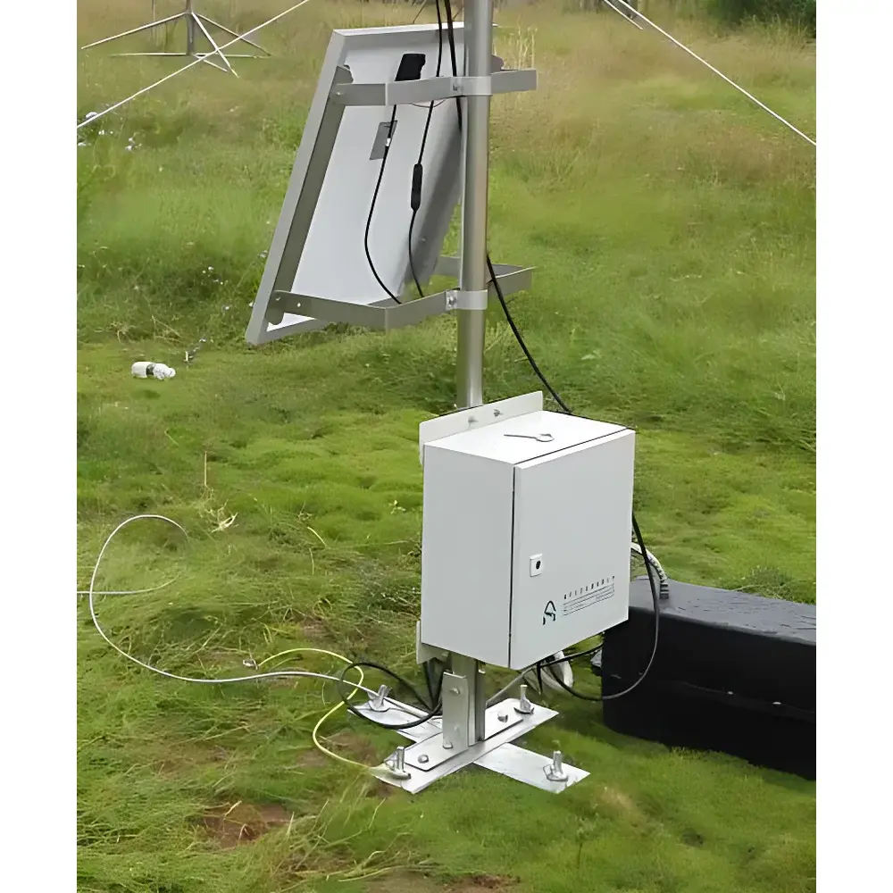
The AZ ENVIdata-CT Infrared Canopy Temperature Monitoring System is a field-deployable, research-grade ecosystem monitoring platform engineered for non-contact, high-temporal-resolution measurement of surface temperature across plant canopies at the community scale. It operates on the physical principle of infrared radiometry—specifically, passive detection of thermal infrared radiation (8–14 µm spectral band) emitted from vegetation surfaces, calibrated in accordance with the Stefan-Boltzmann law. This enables quantitative derivation of canopy surface temperature (Tc) without physical contact, preserving natural microclimate conditions and avoiding perturbation during measurement. Unlike point-sensor setups, the ENVIdata-CT integrates a programmable 360° rotational mount to spatially resolve directional thermal heterogeneity—capturing diurnal and azimuthal variation in leaf surface temperature under changing solar geometry. Such data are critical for estimating crop water stress status via thermal indices (e.g., Crop Water Stress Index, CWSI), validating land surface models, and interpreting stomatal conductance dynamics in response to atmospheric vapor pressure deficit (VPD) and soil moisture availability.
Key Features
- Motorized 360° azimuthal rotation platform with programmable angular step resolution and positional repeatability < ±0.5°, enabling synchronized multi-angle thermal sampling across defined sectors.
- High-stability Apogee SI-111 precision infrared radiometer (calibrated traceable to NIST standards), featuring thermopile detector with built-in thermistor reference and automatic ambient temperature compensation.
- Modular data acquisition unit with 18-bit analog-to-digital conversion (±0.025% full-scale accuracy), supporting up to 6 single-ended or 4 differential analog inputs, 8 pulse-counting channels, and 4 digital I/O lines.
- Flexible sampling configuration: user-defined intervals from 10 ms to 24 hours; real-time clock with battery-backed memory for time-stamped logging.
- Multi-sensor expandability: compatible with industry-standard environmental probes—including air temperature/humidity (Vaisala HMP155), wind speed/direction (RM Young 05103), PAR/solar irradiance (Apogee SQ series), soil temperature (thermistors), barometric pressure, and tipping-bucket rain gauge.
- Ruggedized aluminum enclosure rated IP65, operational across -55°C to +80°C ambient and 0–100% RH non-condensing environments.
Sample Compatibility & Compliance
The ENVIdata-CT is designed for long-term unattended deployment in open-field agricultural plots, grassland ecosystems, agroforestry systems, and semi-arid ecotones. Its non-invasive infrared sensing modality ensures compatibility with all vascular plant species, including cereals, legumes, shrubs, and broadleaf trees—regardless of leaf morphology, pubescence, or wettability. The system conforms to ISO 9001:2015 quality management requirements for design, integration, and calibration documentation. While not certified to IEC 61000-6-2/4 for EMC immunity, its analog signal conditioning and shielded cabling meet standard field instrumentation practices for electromagnetic resilience in rural deployments. Data integrity protocols align with GLP-compliant field research workflows, including timestamped metadata embedding and hardware-level error flagging for sensor timeout or out-of-range readings.
Software & Data Management
The ENVIdata platform provides secure, web-accessible data handling through a dual-deployment architecture: on-premise server installation or hosted cloud service managed by AZ. All communications utilize TLS 1.2 encryption over GPRS, Ethernet, or USB tethering. The ENVIdata Server software supports automated ingestion of time-series sensor records, configurable alarm thresholds (e.g., Tc > 38°C for drought stress indication), and audit-trail logging per FDA 21 CFR Part 11 principles—including user authentication, session tracking, and immutable record archiving. Web interface features include interactive multi-parameter time-series plotting (with zoom, pan, and export to CSV/PNG), GIS-integrated multi-site map visualization, and scheduled report generation (daily summaries, weekly anomalies). Historical datasets retain full sensor metadata—including calibration dates, firmware versions, and GPS-tagged deployment coordinates—ensuring traceability for peer-reviewed publication and regulatory reporting.
Applications
- Quantifying spatial and temporal variability in canopy temperature gradients under heterogeneous irrigation regimes.
- Deriving thermal-based stress indicators (CWSI, Ig) for precision irrigation scheduling in wheat, maize, and cotton production systems.
- Validating energy balance partitioning (LE/Rn ratio) in eddy covariance flux towers.
- Assessing microclimatic buffering capacity of intercropping systems and cover crop canopies.
- Supporting phenological modeling by correlating thermal accumulation (growing degree days derived from Tc) with reproductive stage transitions.
- Long-term ecological monitoring of heatwave impacts on native grassland species composition and mortality risk.
FAQ
What is the spectral response range of the SI-111 infrared sensor used in this system?
The Apogee SI-111 operates in the 8–14 µm long-wave infrared band, optimized for terrestrial surface temperature measurement and compliant with Planck’s law emission maxima for objects near ambient temperatures.
Can the system operate autonomously for extended periods without maintenance?
Yes—field-tested deployments exceed 12 months on sealed lead-acid or lithium-iron-phosphate batteries with solar charging; low-power sleep modes reduce average current draw to <10 mA between scans.
Is the rotation platform compatible with third-party weather stations or telemetry hardware?
The system provides RS-232, USB, and Ethernet interfaces with Modbus RTU/TCP protocol support, enabling interoperability with Campbell Scientific CR-series loggers and other SCADA-compatible infrastructure.
How is emissivity accounted for in temperature calculations?
The SI-111 is factory-calibrated for ε = 0.95 (typical for green vegetation); users may apply site-specific emissivity corrections via software-configurable offset parameters when measuring non-vegetative surfaces (e.g., bare soil, plastic mulch).
Does the ENVIdata platform support integration with external GIS or statistical analysis tools?
Yes—CSV and NetCDF exports are fully structured for direct import into R, Python (pandas/xarray), ArcGIS Pro, and MATLAB; API endpoints allow programmatic access to live and historical datasets.