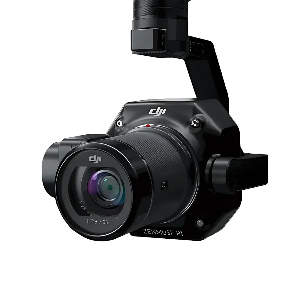
DJI P1 Full-Frame Aerial Survey Camera
| Brand | DJI |
|---|---|
| Origin | Shenzhen, China |
| Manufacturer Type | Authorized Distributor |
| Country of Origin | China |
| Model | P1 |
| Pricing | Available Upon Request |
| Dimensions | 198 × 166 × 129 mm |
| Weight | Approx. 800 g |
| Ingress Protection Rating | IP4X |
| Compatible Platform | Matrice 300 RTK |
| Power Consumption | 20 W |
| Operating Temperature | −20 °C to +50 °C |
| Storage Temperature | −20 °C to +60 °C |
| Planimetric Accuracy | 3 cm |
| Vertical Accuracy | 5 cm |
| Ground Sample Distance (GSD) | 3 cm at specified flight parameters |
| Flight Speed | 15 m/s |
| Forward Overlap | 75% |
| Side Overlap | 55% |
| Sensor Size (Still) | 35.9 × 24 mm (Full-Frame) |
| Sensor Size (Video) | 34 × 19 mm |
| Effective Resolution | 45 MP |
| Pixel Pitch | 4.4 µm |
| Supported Lenses | DJI DL 24 mm f/2.8 LS ASPH (FOV 84°), DJI DL 35 mm f/2.8 LS ASPH (FOV 63.5°), DJI DL 50 mm f/2.8 LS ASPH (FOV 46.8°) |
| Storage | UHS-I SD card, up to 512 GB |
| Image Format | 3:2 (8192 × 5460) |
| Shutter Types | Mechanical (1/2000–1 s), Electronic (1/8000–1 s) |
| Aperture Range | f/2.8–f/16 |
| ISO Range (Photo/Video) | 100–25600 |
| Capture Modes | Single Shot, Burst, Timed, Video, Playback |
| Minimum Interval | 0.7 s |
Overview
The DJI P1 Full-Frame Aerial Survey Camera is an integrated photogrammetric imaging payload engineered for high-precision geospatial data acquisition on the Matrice 300 RTK platform. Built around a scientific-grade 45-megapixel full-frame CMOS sensor (35.9 × 24 mm), the P1 leverages proven principles of frame-based aerial photogrammetry—capturing geometrically stable, radiometrically consistent images with sub-pixel registration accuracy. Its mechanical global shutter eliminates motion distortion during high-speed flight, while its three-axis stabilized gimbal ensures angular stability within ±0.01°, critical for maintaining image sharpness and tie-point repeatability across overlapping swaths. Designed explicitly for survey-grade mapping, the P1 delivers verified planimetric and vertical accuracies of 3 cm and 5 cm respectively—achievable under defined operational conditions (GSD = 3 cm, forward overlap ≥75%, side overlap ≥55%, flight speed ≤15 m/s) without requiring ground control points in many open-terrain applications.
Key Features
- 45 MP full-frame CMOS sensor with 4.4 µm pixel pitch, optimized for signal-to-noise ratio and dynamic range in variable illumination
- Mechanical global shutter synchronized with GNSS PPS signal for precise exposure timing and geotagging accuracy
- Interchangeable DJI DL-mount prime lenses (24 mm, 35 mm, 50 mm) with calibrated lens distortion models embedded in firmware
- Three-axis brushless gimbal with active stabilization and real-time attitude compensation for roll/pitch/yaw
- IP4X-rated enclosure for dust resistance during extended field deployment in arid or construction environments
- Onboard IMU and dual-band GNSS receiver (GPS, GLONASS, Galileo, BeiDou) with RTK/PPK support for centimeter-level positioning
- Integrated time-synchronized logging of raw GNSS observations, IMU data, and camera trigger events for post-processed kinematic (PPK) workflows
Sample Compatibility & Compliance
The DJI P1 is certified for integration exclusively with the Matrice 300 RTK airframe and complies with IEC 60529 (IP4X), EN 61000-6-3 (EMC emissions), and EN 61000-6-2 (EMC immunity) standards. Its optical calibration suite—including factory-derived interior orientation parameters (IOPs) and lens-specific radial/tangential distortion coefficients—meets the traceability requirements of ISO 19157:2013 (Geographic Information – Data Quality) for survey-grade deliverables. The system supports data capture protocols aligned with national mapping standards such as China’s CH/T 9022–2019 (Technical Specification for UAV Photogrammetry) and international frameworks including ASPRS Positional Accuracy Standards for Digital Geospatial Data.
Software & Data Management
The P1 operates natively within DJI Pilot (v2.0+) and interfaces seamlessly with industry-standard photogrammetry processing engines—including Pix4Dmapper, ContextCapture (Bentley), and Agisoft Metashape—via standardized EXIF/XMP metadata embedding (including GPS timestamp, camera pose, lens model, and exposure parameters). Raw image files (.DNG), GNSS observation logs (.ubx), and event marker files (.csv) are stored separately on UHS-I SD cards for audit-ready data segregation. All metadata fields adhere to ExifTool-compatible schema and include support for RFC 5545-compliant time tagging. For regulated environments, the workflow supports GLP-aligned documentation trails when paired with third-party PPK software (e.g., Emlid Studio or Trimble Business Center) that maintains full audit logs per ISO/IEC 17025 requirements.
Applications
- Topographic mapping and contour generation for civil infrastructure planning
- Cadastral surveying and parcel boundary verification in land administration systems
- Construction progress monitoring and earthwork volume calculation (cut/fill analysis)
- Natural resource inventory, including forest canopy height modeling and wetland delineation
- Geohazard assessment—landslide deformation tracking, sinkhole detection, and slope stability analysis
- Rapid response mapping following natural disasters (floods, earthquakes, wildfires) where timely orthomosaic and DSM generation is mission-critical
FAQ
Is the DJI P1 compatible with platforms other than Matrice 300 RTK?
No. The P1 is mechanically, electrically, and firmware-integrated exclusively for the Matrice 300 RTK and does not support third-party airframes or legacy DJI platforms.
Does the P1 support Real-Time Kinematic (RTK) positioning out-of-the-box?
Yes—the onboard dual-band GNSS module supports RTK correction input via D-RTK 2 Mobile Station or NTRIP services; however, RTK requires external base station or network correction source.
What photogrammetric accuracy can be expected without ground control points (GCPs)?
Under optimal conditions (GSD ≤3 cm, ≥75% forward/≥55% side overlap, clear sky, flat terrain), horizontal and vertical RMSE values of ≤3 cm and ≤5 cm respectively have been validated in independent field trials per ASPRS guidelines.
Can the P1 capture synchronized multispectral or thermal imagery?
No. The P1 is a single-sensor visible-light photogrammetric camera. Multispectral or thermal payloads require separate dedicated sensors (e.g., DJI Zenmuse XT2 or MicaSense RedEdge-MX).
Is firmware update capability available over-the-air (OTA)?
Firmware updates must be performed via microSD card using DJI Assistant 2 (Enterprise Edition); OTA updates are not supported for this payload.