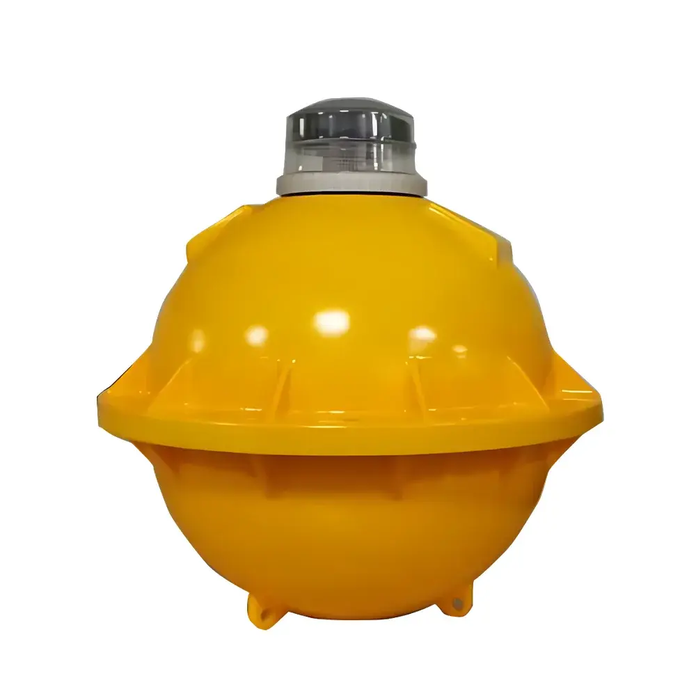
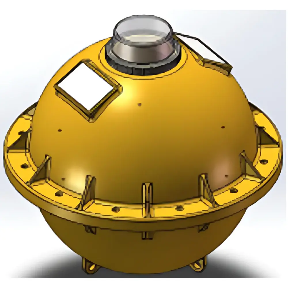
Langcheng LS-DB300MM Surface Drifting Buoy for Ocean Current Tracking
| Origin | Guangdong, China |
|---|---|
| Manufacturer Type | Authorized Distributor |
| Origin Category | Domestic (PRC) |
| Model | LS-DB300MM |
| Price | USD 2,800 (FOB Shenzhen) |
Overview
The Langcheng LS-DB300MM Surface Drifting Buoy is an autonomous, GPS/BeiDou dual-mode satellite-tracked oceanographic platform engineered for high-fidelity Lagrangian observation of surface current dynamics. Operating on the principle of passive drift tracking—where the buoy’s motion approximates that of near-surface water parcels—the system delivers georeferenced position time-series with sub-10-meter horizontal accuracy under open-sky conditions. Designed to comply with IOC/GOOS (Intergovernmental Oceanographic Commission / Global Ocean Observing System) buoy metadata standards, the LS-DB300MM serves as a foundational node in coastal and offshore observational networks, supporting operational oceanography, marine boundary layer modeling, and oil spill trajectory forecasting.
Key Features
- Integrated dual-constellation GNSS receiver (GPS L1 + BeiDou B1I) enabling robust positioning across the Western Pacific, South China Sea, and inland waterways
- Low-power embedded control unit with configurable sampling intervals (1–360 minutes) and transmission cycles (1–1440 minutes), supporting adaptive duty cycling to extend mission duration
- Modular sensor interface (RS-485 + analog 0–5 V) compatible with industry-standard CTD sensors (e.g., Sea-Bird Electronics SBE-37, RBRconcerto), dissolved oxygen probes, and turbidity meters
- High-visibility LED navigation light (IP68-rated, 1000 cd intensity, red/white selectable) controllable via remote command over BeiDou short message service (SMS)
- Rechargeable lithium iron phosphate (LiFePO₄) battery pack (12 Ah nominal capacity) with solar-assisted charging circuitry; field-tested endurance of 30–240 days depending on sampling frequency and environmental insolation
- Hydrodynamically optimized polyethylene buoy body (Ø300 mm × H420 mm, mass ≤4.2 kg) with integrated water sail (0.15 m² projected area) to minimize wind slip and enhance current-following fidelity
- Marine-grade ABS housing for electronics compartment (IP67 ingress protection), corrosion-resistant stainless-steel mooring fittings, and UV-stabilized polymer construction rated for >5-year service life in tropical seawater
Sample Compatibility & Compliance
The LS-DB300MM is validated for deployment in estuarine, lacustrine, and pelagic environments—including Class I–III marine waters per China’s GB 3097-1997 standards—and exhibits stable performance under wave heights up to 2.5 m (significant wave height, Hs). Its mechanical design conforms to IMO Resolution A.689(17) for low-risk floating aids to navigation. Data telemetry meets ITU-R M.1371-5 specifications for maritime AIS-like reporting integrity. Firmware supports UTC-synchronized timestamps traceable to NTP servers via BeiDou time broadcast, satisfying ISO/IEC 17025:2017 requirements for time-stamped measurement records in accredited environmental monitoring laboratories.
Software & Data Management
Raw GNSS coordinates, sensor readings, and system health metrics (battery voltage, internal temperature, signal-to-noise ratio) are transmitted via BeiDou RDSS (Radio Determination Satellite Service) or optional Iridium Short Burst Data (SBD) link. The Langcheng BuoyLink™ desktop application (Windows/macOS) provides real-time dashboard visualization, automated track interpolation using Kalman filtering, and export to CF-compliant NetCDF files. All data packets include CRC-16 checksums and support optional AES-128 encryption. Audit logs record all remote configuration changes with user ID, timestamp, and parameter delta—enabling full traceability for GLP/GMP-aligned QA/QC workflows and regulatory submissions to MNR (Ministry of Natural Resources, PRC) or NOAA-NCEI archives.
Applications
- Ocean current validation for HYCOM and ROMS numerical models
- Coastal sediment transport pathway analysis during monsoon-driven circulation shifts
- Real-time input for fisheries management systems (e.g., dynamic closed-area designation based on thermal front detection)
- Calibration reference for HF radar and satellite altimetry-derived surface velocity fields
- Emergency response monitoring of hazardous material dispersion (e.g., chemical spills, radioactive effluent plumes)
- Long-term trend analysis of nearshore circulation resilience under climate variability (ENSO, PDO phases)
FAQ
What is the typical horizontal positioning accuracy under open-sky conditions?
Sub-10 meter CEP (Circular Error Probable) at 95% confidence level when using combined GPS/BeiDou observations; degrades to ≤25 m under partial canopy or urban canyon conditions.
Can the buoy operate in ice-covered or high-latitude waters?
Not recommended for sustained operation below −5°C ambient or in mechanically active ice zones; battery performance and LED optical output decline outside the −10°C to +55°C operating envelope.
Is firmware upgrade supported over-the-air?
Yes—via encrypted BeiDou SMS or Iridium SBD; requires prior registration of public key infrastructure (PKI) credentials in the BuoyLink™ provisioning portal.
Does the system meet FDA 21 CFR Part 11 requirements for electronic records?
While not certified for pharmaceutical use, its audit trail, electronic signature support, and immutable log architecture align with core technical controls outlined in Part 11 Subpart B for regulated environmental data collection.
What is the maximum depth rating for optional pressure/temperature sensors?
Sensor integration is limited to surface-referenced measurements; the buoy itself is not designed for submersion beyond splash zone—no pressure housing is provided for attached transducers.
Related Products