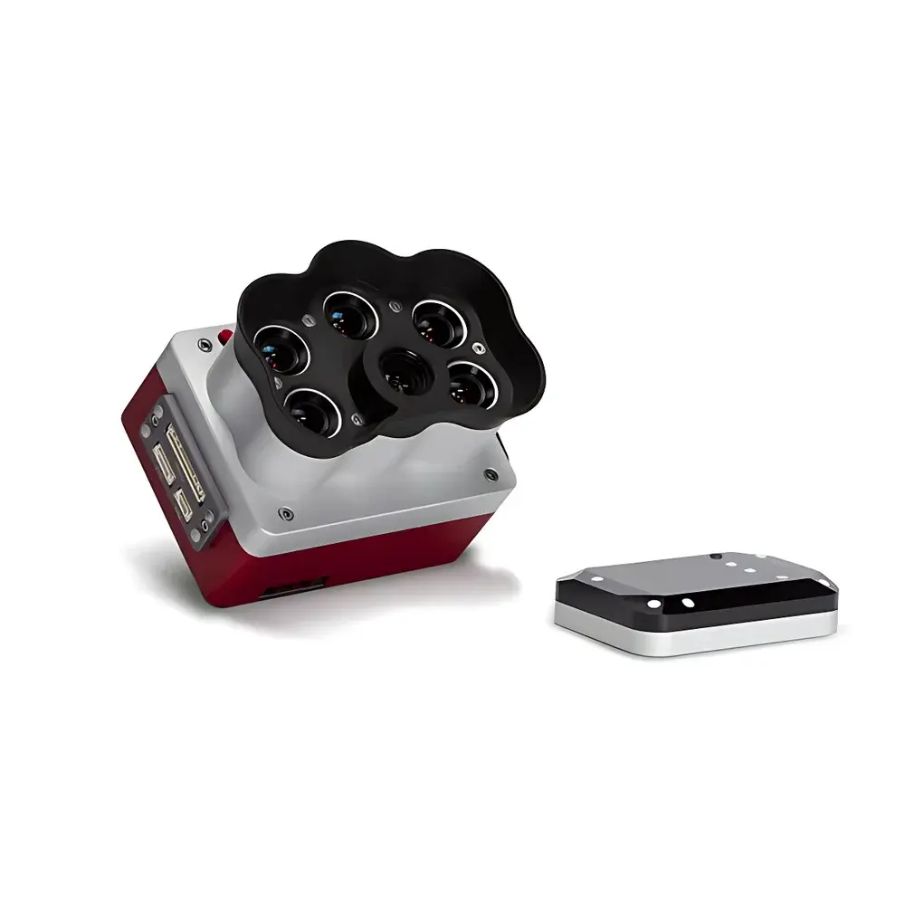
MicaSense RedEdge-P High-Resolution Multispectral Camera
| Brand | MicaSense |
|---|---|
| Model | RedEdge-P |
| Weight | 350 g |
| Dimensions (L×W×H) | 8.9 × 7.0 × 6.7 cm |
| Sensor Resolution (Multispectral) | 1456 × 1088 px per band (1.6 MP) |
| Panchromatic Resolution | 2464 × 2056 px (5.1 MP) |
| GSD | 8 cm/pixel @ 120 m AGL (MS bands) |
| GSD | 4 cm/pixel @ 120 m AGL (PAN band) |
| FOV | 50° H × 38° V (MS), 44° H × 38° V (PAN) |
| Spectral Bands | Blue (475 nm, 32 nm FWHM), Green (560 nm, 27 nm FWHM), Red (668 nm, 14 nm FWHM), Red Edge (717 nm, 12 nm FWHM), NIR (842 nm, 57 nm FWHM) |
| Capture Rate | 3×/sec (raw DNG) |
| Storage | CFexpress Type B card (64 GB – 2 TB) |
| Interface | Compatible with RedEdge-MX mounting and electrical interface (adapter kit required) |
Overview
The MicaSense RedEdge-P is a professional-grade, high-resolution multispectral imaging sensor engineered for precision agricultural monitoring, ecological surveying, and environmental remote sensing applications. Unlike conventional multispectral cameras that rely on spatial interpolation or image fusion from disparate sensors, the RedEdge-P integrates five synchronized scientific-grade spectral channels with a dedicated panchromatic (PAN) band—enabling true pixel-aligned, radiometrically calibrated multispectral data acquisition at sub-10 cm ground sampling distance (GSD). Its optical architecture employs narrowband, interference-based filters with tight full-width half-maximum (FWHM) tolerances and factory-calibrated spectral response functions, ensuring high inter-band registration accuracy and long-term radiometric stability. The system operates on the principle of simultaneous multispectral capture using global shutter CMOS sensors, eliminating motion-induced misregistration common in scanning or sequential capture systems. Designed for integration onto UAV platforms—including fixed-wing and multirotor drones—the RedEdge-P delivers consistent, repeatable data across flight campaigns spanning multiple growing seasons, supporting time-series analysis of canopy structure, chlorophyll content, water stress, and biomass accumulation.
Key Features
- Integrated panchromatic band (2464 × 2056 px) enabling pan-sharpened multispectral outputs with 2× improved spatial resolution—achieving 2 cm/pixel GSD at 60 m AGL, double the resolution of the legacy RedEdge-MX.
- Five co-aligned spectral bands with scientifically validated center wavelengths and narrow bandwidths: Blue (475 nm ±16 nm), Green (560 nm ±13.5 nm), Red (668 nm ±7 nm), Red Edge (717 nm ±6 nm), and Near-Infrared (842 nm ±28.5 nm).
- Global shutter CMOS sensors with uniform quantum efficiency response and factory-applied radiometric calibration coefficients embedded in every raw DNG file.
- CFexpress Type B storage interface supporting sustained write speeds >1.5 GB/s—enabling continuous capture of all five spectral bands plus PAN at 3 frames per second for over 24 hours per card (up to 2 TB capacity).
- Compact, ruggedized housing (350 g, IP64-rated enclosure) with thermal management optimized for extended operation in variable ambient conditions (−10 °C to +50 °C).
- Backward-compatible mechanical and electrical interface with RedEdge-MX platforms—upgradable via optional adapter kit without requiring airframe modification.
Sample Compatibility & Compliance
The RedEdge-P is designed for outdoor aerial deployment and does not require sample preparation or contact-based measurement. It captures reflected solar radiation from vegetated surfaces, soil, water bodies, and built environments within its specified spectral range (400–900 nm). Data output conforms to industry-standard radiometric metadata conventions (EXIF + XMP sidecar), including exposure time, ISO gain, lens distortion coefficients, and sensor temperature. All spectral band responses are traceable to NIST-calibrated reference standards, and the factory calibration report includes uncertainty budgets per band (k=2). The system supports compliance workflows aligned with ASTM E2921 (Standard Practice for Onboard Calibration of Multispectral Imaging Sensors) and ISO 18620-2 (Remote Sensing—Calibration and Validation of Optical Sensors). While not certified for medical or pharmaceutical use, its radiometric fidelity meets requirements for GLP-compliant vegetation phenotyping studies and USDA-funded precision agriculture trials.
Software & Data Management
Raw DNG files generated by the RedEdge-P are natively supported by MicaSense’s Atlas cloud processing platform, which applies automated radiometric correction, orthorectification, band co-registration, and vegetation index computation (NDVI, NDRE, CIrededge, SAVI, etc.). Local processing is enabled via open-source tools including OpenDroneMap (ODM), Agisoft Metashape, and Python-based libraries such as rsutils and earthpy. Each image contains embedded calibration matrices and vignetting maps, allowing reproducible reflectance conversion using empirical line or dark-reference methods. Atlas provides audit-trail logging compliant with FDA 21 CFR Part 11 for electronic records and signatures when configured with enterprise authentication and role-based access control. Export formats include GeoTIFF, Cloud Optimized GeoTIFF (COG), and ENVI-compatible BIL stacks—suitable for ingestion into GIS platforms (ArcGIS Pro, QGIS) and statistical analysis environments (R, MATLAB).
Applications
- High-resolution crop health mapping across phenological stages—from emergence through senescence—with detection sensitivity to early nitrogen deficiency, water stress, and pest infestation.
- Forestry inventory and canopy structure modeling using pan-sharpened NDVI and red-edge indices to differentiate species and estimate leaf area index (LAI) at plot scale.
- Wetland and riparian zone monitoring, including submerged aquatic vegetation classification and turbidity estimation via blue/green band ratio analysis.
- Post-wildfire regrowth assessment using temporal NDVI differencing and burn severity indexing (dNBR) derived from pre- and post-event datasets.
- Urban green infrastructure evaluation, including tree canopy cover quantification, impervious surface mapping, and stormwater retention modeling.
FAQ
Does the RedEdge-P require external lighting or illumination sources?
No. The sensor is passive and relies exclusively on ambient solar irradiance. It includes an integrated downwelling light sensor (DLS 2) for real-time illumination normalization.
Can I process RedEdge-P data offline without cloud subscription?
Yes. Raw DNG files contain all necessary calibration metadata; open-source photogrammetry and radiometric correction pipelines support fully offline processing.
Is the RedEdge-P compatible with Pix4Dmapper and DroneDeploy?
Yes. Both platforms support RedEdge-P DNG imports and automatically recognize embedded band definitions and calibration parameters.
What is the recommended flying altitude for optimal GSD in multispectral mode?
For 8 cm/pixel GSD, fly at 120 m AGL; for 4 cm/pixel (pan-sharpened), maintain 120 m AGL and apply pan-sharpening during post-processing.
How often does the sensor require recalibration?
Factory calibration is stable for ≥2 years under normal operating conditions. Recalibration is recommended after physical impact, prolonged exposure to extreme temperatures (>60 °C), or if radiometric drift exceeds ±3% relative to reference targets.