MSP3 Mobile Soil OM-EC-pH Mapping System
| Origin | USA |
|---|---|
| Manufacturer Type | Authorized Distributor |
| Origin Category | Imported |
| Model | MSP3 |
| Instrument Type | Multi-parameter In-situ Soil Analyzer |
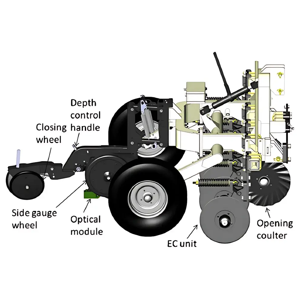
| Optical Sensors | VIS (660 nm) & NIR (940 nm) LED-based Spectral Reflectance Sensors |
| EC Measurement | Dual-depth galvanic contact conductivity profiling (0–45 cm & 0–91 cm) |
| pH Sensing | Antimony-based ion-selective electrode (6–12 cm adjustable depth) |
| OM Depth Range | 38–76 mm |
| GPS | Garmin GPS 19X (NMEA 0183 compliant) |
| Data Acquisition | 1 Hz PIC microcontroller (80-pin), SD card logging, backlit display |
| Environmental Rating | NMEA 4X sealed electronics, MIL-spec waterproof connectors |
| Operating Temperature | −20 °C to +70 °C |
| Vehicle Requirements | ≥30 hp tractor or light utility vehicle |
| Transport Configuration | Towed chassis (229 cm W × 396 cm L × 152 cm H |
| Max Survey Speed | 20 km/h |
| Software | SoilViewer v4.x (real-time georeferenced visualization, 2D spatial interpolation, export to GIS formats) |
Overview
The MSP3 Mobile Soil OM-EC-pH Mapping System is an integrated, vehicle-mounted in-situ soil characterization platform engineered for high-resolution, real-time geospatial mapping of three critical soil properties: organic matter (OM) content, apparent electrical conductivity (ECa), and pH. Unlike conventional lab-based analysis—where sample collection, transport, drying, grinding, and extraction introduce temporal lag, spatial aliasing, and procedural bias—the MSP3 performs direct-contact, on-the-go measurements across contiguous field areas. Its operational principle combines galvanic EC profiling (based on Ohm’s law and bulk soil conductivity response to applied current), potentiometric pH determination via antimony-referenced ion-selective electrodes, and empirical calibration of visible–near-infrared (VIS-NIR) spectral reflectance (660 nm and 940 nm) to predict surface-layer OM concentration. The system leverages the physical correlation between spectral absorption features (e.g., C–H and O–H overtones in NIR) and soil organic carbon content, validated against regional pedotransfer functions developed by Veris Technologies and peer-reviewed in USDA-ARS and KSU agronomy studies. Designed for deployment on light agricultural tractors or UTVs, the MSP3 delivers sub-hectare spatial resolution (120–240 measurement points per hectare) without soil disturbance, enabling scalable digital soil mapping aligned with FAO’s Global Soil Partnership frameworks.
Key Features
- Simultaneous dual-depth EC profiling: Independent 0–45 cm (shallow) and 0–91 cm (deep) conductivity layers mapped in a single pass, supporting stratified interpretation of soil texture, clay content, and salinity distribution.
- Direct-contact EC measurement: Galvanic electrode array eliminates electromagnetic interference susceptibility and removes need for routine solution-based calibration—ensuring long-term measurement stability across variable field conditions.
- VIS-NIR optical sensing: LED-illuminated 660 nm (red edge) and 940 nm (water absorption band) reflectance detection enables rapid estimation of topsoil OM (38–76 mm depth) with traceable uncertainty propagation from Veris-certified calibration models.
- Adjustable pH probe insertion: Mechanically controlled 6–12 cm depth setting accommodates varying tillage histories and root zone definitions; antimony electrode design provides robustness in alkaline and saline soils where glass electrodes degrade.
- Integrated GNSS positioning: Garmin GPS 19X delivers sub-meter horizontal accuracy (SBAS-corrected), synchronized at 1 Hz with all sensor streams to ensure georeferencing integrity for GIS-ready output.
- Ruggedized mobile architecture: NMEA 4X-sealed electronics, MIL-spec connectors, and industrial-grade PIC microcontroller support continuous operation in dust, rain, and thermal extremes (−20 °C to +70 °C).
Sample Compatibility & Compliance
The MSP3 is validated for use across mineral soils (sand to clay loam), calcareous and sodic substrates, and managed agroecosystems including row crops, orchards, and pasturelands. It is not intended for use in saturated peat, rocky outcrops, or heavily gravelly (>25% stone fraction) terrain where sensor-ground coupling is compromised. All EC and pH measurements comply with ASTM D257 (Standard Test Methods for DC Resistance or Conductance of Insulating Materials) and ISO 10390:2021 (Soil quality — Determination of pH). Spectral OM estimates are traceable to NIST-traceable reflectance standards and calibrated per Veris Data Processing Center protocols (v3.2+), which incorporate site-specific validation using loss-on-ignition (LOI) and Walkley–Black reference methods. The system meets GLP documentation requirements for field data acquisition when paired with SoilViewer’s audit-log-enabled export workflow.
Software & Data Management
SoilViewer software serves as the unified interface for real-time telemetry, spatial interpolation, and export. It displays live GPS-tagged EC, pH, and raw spectral reflectance values on a moving map, applies kriging or inverse distance weighting (IDW) to generate interpolated raster surfaces, and exports GeoTIFF, Shapefile, and CSV formats compatible with ArcGIS, QGIS, and Farm Management Information Systems (FMIS). Raw spectral data are uploaded to the Veris Data Processing Center for OM prediction using proprietary multivariate regression models trained on >15,000 field-collected samples across North America and Europe. All data logs include timestamps, position metadata, sensor health flags, and acquisition rate diagnostics. SoilViewer supports 21 CFR Part 11-compliant user authentication, electronic signatures, and immutable audit trails when deployed on Windows OS with domain-level security policies.
Applications
- Precision agriculture zoning: Deriving management zones for variable-rate irrigation, lime, fertilizer, and seed prescription based on co-located EC–pH–OM gradients.
- Soil carbon stock assessment: Supporting Tier 2 IPCC methodologies for farm-scale SOC change monitoring under carbon farming initiatives and voluntary carbon markets.
- Salinity and sodicity screening: Rapid identification of Na+-affected zones through depth-differential EC response and pH correlation.
- Land-use planning and remediation: Characterizing legacy contamination plumes, landfill boundaries, or reclaimed mine soils via anomalous EC/pH/OM signatures.
- Research-grade soil survey: Generating high-density baseline maps for LUCAS-like harmonized soil monitoring programs under EU Joint Research Centre guidelines.
- Extension and education: Demonstrating spatial soil heterogeneity in real time for stakeholder engagement and decision-support training.
FAQ
How does the MSP3 differentiate between shallow and deep EC signals?
The system employs two independent galvanic electrode arrays with fixed inter-electrode spacings (1.0 m and 2.0 m), each generating distinct effective investigation depths governed by the Wenner configuration principle—approximately 0–45 cm and 0–91 cm, respectively.
Is laboratory validation required before deploying the OM model?
Yes. While the VIS-NIR model is pre-calibrated, users must collect 15–20 representative grab samples per field for LOI or dry combustion analysis to locally validate and optionally refine slope/intercept parameters within SoilViewer’s calibration module.
Can the MSP3 operate on steep or uneven terrain?
It is rated for slopes ≤15% and requires stable wheel-track contact. On highly undulating land, GPS positional drift may exceed ±2 m; differential correction (e.g., RTK or PPK) is recommended for sub-meter fidelity.
What maintenance is required for the pH electrode?
The antimony electrode requires periodic cleaning with dilute HCl (0.1 M) and storage in pH 4 buffer; no refilling or membrane replacement is needed—typical service life exceeds 2,000 km of field operation.
Does the system support integration with ISOXML or ADAPT protocols?
SoilViewer exports shapefiles and GeoTIFFs compatible with ISOXML v4.3 import pipelines; native ADAPT integration is available via optional middleware licensed through Veris Partners.
Related Products