SAIL HERO XHGGP-90B Tower-Mounted Pushbroom Hyperspectral Imaging System for Water Quality Remote Sensing
| Brand | SAIL HERO |
|---|---|
| Origin | Hebei, China |
| Manufacturer Type | Original Equipment Manufacturer (OEM) |
| Country of Origin | China |
| Model | XHGGP-90B |
| Operating Principle | Pushbroom Scanning |
| Imaging Method | Dispersive (Prism/Grating-based) |
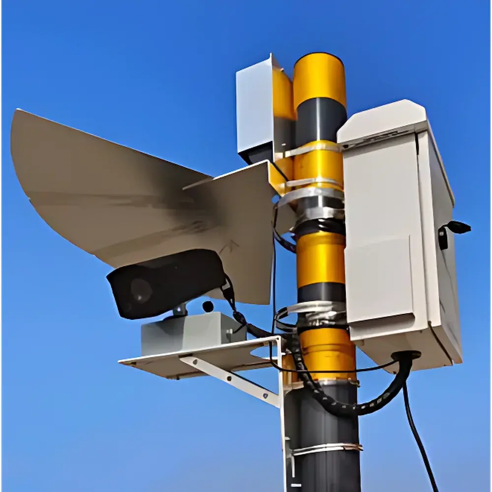
| Deployment Mode | Ground-Based Fixed Tower Mount |
| Spectral Range | 400–1000 nm |
| Spectral Resolution | ≤2 nm FWHM @ 546.1 nm |
| Total Field of View (TFOV) | ≥20° |
| Instantaneous Field of View (IFOV) | 0.08 m (at 50 m installation height, 30° tilt angle) |
| Spectral Bands | >200 channels |
| Real-Time Processing Capability | Yes |
| Water Parameter Retrieval | ≥15 parameters (e.g., TSS, Turbidity, Secchi Depth, Zn, Cu, Pb, Chlorophyll-a, COD, DO, TP, TN, NH₃-N) |
| Data Transmission | Multi-destination upload support |
| Calibration | Onboard solar tracking + electronic white-board radiometric calibration |
| Software Modes | Scanning Imaging Mode & Fixed-Point Monitoring Mode |
| Georeferencing | Manual ROI-based water body delineation |
| Data Integration | Manual lab sample import for post-acquisition spectral calibration |
Overview
The SAIL HERO XHGGP-90B Tower-Mounted Pushbroom Hyperspectral Imaging System is a ground-based, fixed-deployment remote sensing platform engineered for continuous, high-frequency water quality monitoring across inland surface waters—including reservoirs, lakes, rivers, and urban canals. Utilizing pushbroom scanning architecture with dispersive optics (prism or grating), the system captures spatially resolved reflectance spectra across 200+ contiguous narrow bands from 400 to 1000 nm. Mounted on towers or elevated terrain at heights up to 50 m, it acquires oblique-view hyperspectral image cubes with a total field of view ≥20° and an instantaneous field of view (IFOV) of 0.08 m under standard deployment geometry (30° tilt). The instrument operates on first-principles radiometric inversion: measured top-of-water radiance is corrected for atmospheric path radiance, solar geometry, and sensor response using onboard solar tracking and real-time electronic white-board calibration—enabling quantitative retrieval of optically active and non-optically active water constituents without in-situ proxy dependence.
Key Features
- Two operational modes: pushbroom scanning imaging mode for spatially explicit parameter mapping (e.g., chlorophyll-a distribution across a reservoir), and fixed-point time-series monitoring mode for long-term trend analysis at critical locations.
- Onboard solar irradiance tracking ensures consistent illumination normalization across diurnal cycles; eliminates need for external pyranometer synchronization.
- Electronic white-board radiometric calibration performed prior to each acquisition cycle—maintains radiometric stability over extended deployments without manual intervention.
- Real-time spectral inversion engine processes raw data into georeferenced parameter maps within ≤90 seconds of acquisition, supporting near-real-time alerting for anomalous events (e.g., algal bloom onset, industrial discharge plumes).
- Customizable ROI selection: users define water boundaries interactively via polygon drawing on orthorectified preview imagery—ensuring precise exclusion of shoreline, vegetation, and infrastructure pixels during spectral unmixing.
- Configurable acquisition schedule: supports programmable start/end times (e.g., 08:00–18:00 daily), scan line density, dwell time per pixel, and revisit frequency—optimized for regulatory compliance reporting windows.
- Integrated statistical module provides Pearson/Spearman correlation matrices between retrieved parameters, temporal variance analysis, and percentile-based anomaly detection thresholds.
Sample Compatibility & Compliance
The XHGGP-90B is designed exclusively for open-water surface monitoring and does not require physical sampling. It complies with ISO 17025:2017 general requirements for competence of testing and calibration laboratories (when used in conjunction with traceable reference measurements). Its inversion algorithms are validated against ASTM D5257 (Standard Guide for Spectral Reflectance Measurements of Aquatic Environments) and align with the optical modeling framework described in UNESCO’s “Remote Sensing of Inland Waters” technical guidelines. While not FDA-regulated, its data structure and audit trail capabilities—including timestamped raw cube storage, calibration logs, and user action history—support GLP-compliant environmental monitoring programs and meet baseline requirements for US EPA Region 3 and EU WFD Article 8 reporting frameworks.
Software & Data Management
The proprietary SAIL HERO AquaVision software suite (v4.2+) runs on Windows 10/11 x64 platforms and provides full workflow integration—from acquisition control to model-driven parameter retrieval and export. All raw hyperspectral cubes are stored in ENVI-compatible BIL format with embedded metadata (GPS, IMU, solar zenith, exposure settings). Processed outputs include GeoTIFF rasters with WGS84 UTM projection, CSV time-series logs, and XML-formatted QA/QC reports containing uncertainty estimates per pixel. The system supports dual-mode data delivery: local NAS archiving and concurrent encrypted transmission (TLS 1.2) to up to four independent endpoints—including municipal SCADA systems, provincial environmental data centers, and cloud-hosted GIS platforms. Lab-derived validation measurements (e.g., filtered TSS, spectrophotometric COD) can be imported as CSV to recalibrate empirical or semi-analytical inversion models via weighted least-squares optimization.
Applications
- Long-term eutrophication monitoring in drinking water reservoirs, including seasonal chlorophyll-a dynamics and phosphorus loading estimation.
- Rapid identification and spatial delineation of point-source pollution events (e.g., heavy metal plumes from mining outfalls, organic effluent from wastewater treatment plant overflows).
- Supporting Total Maximum Daily Load (TMDL) implementation by quantifying spatial gradients of turbidity, suspended solids, and nutrient surrogates across watershed scales.
- Calibration/validation of satellite-derived water quality products (e.g., Sentinel-3 OLCI, Landsat 9 OLI-2) through synchronized ground-truthing campaigns.
- Integration into smart city environmental dashboards for public-facing water quality indices aligned with WHO and Chinese MEE Class III/IV standards.
FAQ
What is the minimum detectable concentration for copper (Cu) or lead (Pb) using this system?
The XHGGP-90B does not directly quantify dissolved metal concentrations below detection limits typical of laboratory ICP-MS. Instead, it retrieves surrogate optical properties correlated with particulate-bound metals (e.g., Cu-associated humic absorption features near 620 nm); quantification requires site-specific empirical calibration against grab-sample ICP-OES data.
Can the system operate autonomously for unattended 24/7 monitoring?
Yes—when integrated with industrial-grade UPS and environmental enclosures (IP65 rated), the system supports scheduled operation across daylight hours. Nighttime operation is not supported due to reliance on solar-reflected signal.
Is spectral calibration traceable to NIST standards?
Radiometric calibration uses onboard diffuse reflectance panels certified to ISO 20677:2019; absolute irradiance scaling is traceable to NIST SRM 2036 via annual third-party verification protocol.
Does the software support custom algorithm development?
Yes—the AquaVision SDK (C++/Python APIs) provides access to calibrated radiance cubes, atmospheric correction modules, and inversion kernels, enabling integration of user-defined bio-optical models or machine learning regressors trained on local datasets.