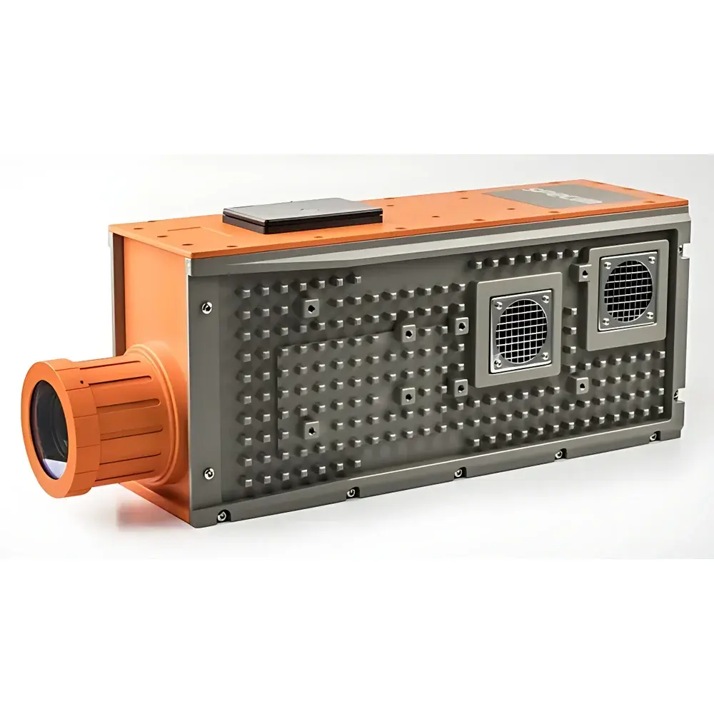
Specim AisaIBIS Sun-Induced Chlorophyll Fluorescence Hyperspectral Imager
| Brand | Specim |
|---|---|
| Origin | Finland |
| Model | AisaIBIS |
| Spectral Range | 670–780 nm |
| Spectral Sampling | 0.11 / 0.22 nm |
| Spatial Resolution | 384 × 768 pixels |
| Aperture | f/1.7 |
| SNR | 680:1 |
| Frame Rate | 65 fps |
| FOV | 32.3° |
| Integration Time | Adjustable per frame |
| Detector | Scientific-grade sCMOS, Peltier-cooled |
| Data Interface | CameraLink (16-bit) |
| Power Consumption | 135 W (typ.), 200 W (max.) |
| System Weight (incl. DPU) | <25 kg |
| Mechanical Shutter | Integrated |
| Thermal Stability | Active optical-thermal stabilization |
Overview
The Specim AisaIBIS is a field-deployable, airborne-capable hyperspectral imager engineered specifically for quantitative mapping of sun-induced chlorophyll fluorescence (SIF) in terrestrial vegetation. Unlike conventional chlorophyll fluorescence imaging systems based on pulsed amplitude modulation (PAM) under controlled illumination, the AisaIBIS operates passively under natural solar irradiance—leveraging the Fraunhofer line depth (FLD) principle to isolate weak SIF signals embedded within atmospheric absorption features at 670–780 nm. This enables non-invasive, spatially resolved quantification of photosynthetic activity across scales—from individual canopies to regional ecosystems—without perturbing plant physiology. Developed jointly by Specim (Finland) and Forschungszentrum Jülich (Germany) for ESA’s SIFLEX mission, the AisaIBIS forms the core sensor of the HyPlant airborne system and represents the first commercially available instrument validated for operational SIF retrieval in both ground-based and aerial remote sensing configurations.
Key Features
- Fraunhofer Line Depth (FLD) methodology optimized for O2-A (760 nm) and O2-B (687 nm) absorption bands—enabling robust SIF retrieval under variable solar zenith angles and atmospheric conditions
- High-throughput f/1.7 optical design with scientific sCMOS detector, delivering 65 fps full-frame acquisition at 0.11 nm spectral sampling (dual resolution modes: 0.11 nm / 0.22 nm)
- Peltier-cooled detector architecture ensuring thermal stability and low dark current—critical for high-dynamic-range (>80 dB), low-noise SIF signal recovery
- Integrated mechanical shutter and active optical-thermal stabilization to minimize radiometric drift during long-duration flight campaigns or tower-based time-series measurements
- Modular integration capability with complementary sensors—including Specim AisaFENIX (VNIR-SWIR, 380–2500 nm) and Thermo-RGB fusion modules—for multi-modal biophysical parameter retrieval (e.g., NDVI, EVI, F760, canopy temperature, emissivity, water content)
Sample Compatibility & Compliance
The AisaIBIS is designed for non-contact, non-destructive measurement of intact vegetation canopies—including agricultural crops, forest stands, grasslands, wetlands, and managed horticultural systems. Its passive solar-driven operation eliminates requirements for artificial excitation sources, making it suitable for long-term ecological monitoring without photoinhibitory artifacts. The system complies with standard protocols for airborne hyperspectral data acquisition defined under ESA’s FLEX mission pre-campaign activities and NASA’s Airborne Visible/Infrared Imaging Spectrometer (AVIRIS-NG) intercomparison frameworks. Radiometric calibration traceability follows NIST-traceable procedures, and raw data output adheres to ENVI-compatible BIL/BIP formats supporting FAIR (Findable, Accessible, Interoperable, Reusable) data principles. While not a regulated medical or pharmaceutical device, its use in GLP-compliant ecosystem phenotyping and carbon flux studies aligns with ISO 17025-accredited laboratory practices when integrated into validated processing chains (e.g., HyPlant L1B → L2A product generation).
Software & Data Management
Raw AisaIBIS data are acquired via CameraLink interface and processed using Specim’s proprietary Imspector software suite, which supports real-time preview, geometric correction, and radiometric calibration. For SIF-specific analysis, the HyPlant Processing Chain (HPC)—an open-source, Python-based workflow maintained by Forschungszentrum Jülich—is recommended. HPC implements rigorous atmospheric correction (using MODTRAN or 6S), FLD-based SIF inversion, and georeferencing aligned with WGS84 UTM projections. Output products include top-of-canopy (TOC) reflectance cubes, absolute SIF radiance maps (µW·m−2·sr−1·nm−1), and derived indices such as F760/F740 ratio. All processing logs are timestamped and support audit trails compatible with 21 CFR Part 11 requirements when deployed in regulated agricultural research environments. Metadata embedding follows CF-NetCDF conventions, facilitating ingestion into Earth observation data infrastructures (e.g., ESA’s Copernicus Data Space Ecosystem).
Applications
- Large-scale gross primary productivity (GPP) estimation—validated against eddy covariance towers and chamber-based CO2 flux measurements (Wieneke et al., RSE 2016)
- Early detection of abiotic stress—including drought, heat, and nutrient deficiency—through SIF depression prior to visible spectral shifts in NDVI or red-edge position
- High-throughput crop phenotyping for breeding programs—enabling spatially explicit trait mapping (e.g., photosynthetic efficiency, stomatal conductance proxies) across field plots
- Forest health assessment and carbon sink monitoring—supporting national greenhouse gas inventories under UNFCCC reporting guidelines
- Integration with LiDAR and thermal infrared systems for 3D structural–physiological modeling of canopy energy balance and transpiration dynamics
FAQ
What distinguishes AisaIBIS from PAM-based chlorophyll fluorescence imagers?
The AisaIBIS measures naturally induced fluorescence under ambient sunlight using the Fraunhofer line depth method, whereas PAM systems require controlled actinic light pulses and saturating flashes—limiting their applicability to laboratory or small-plot field studies.
Can AisaIBIS be used from ground-based platforms such as flux towers or UAVs?
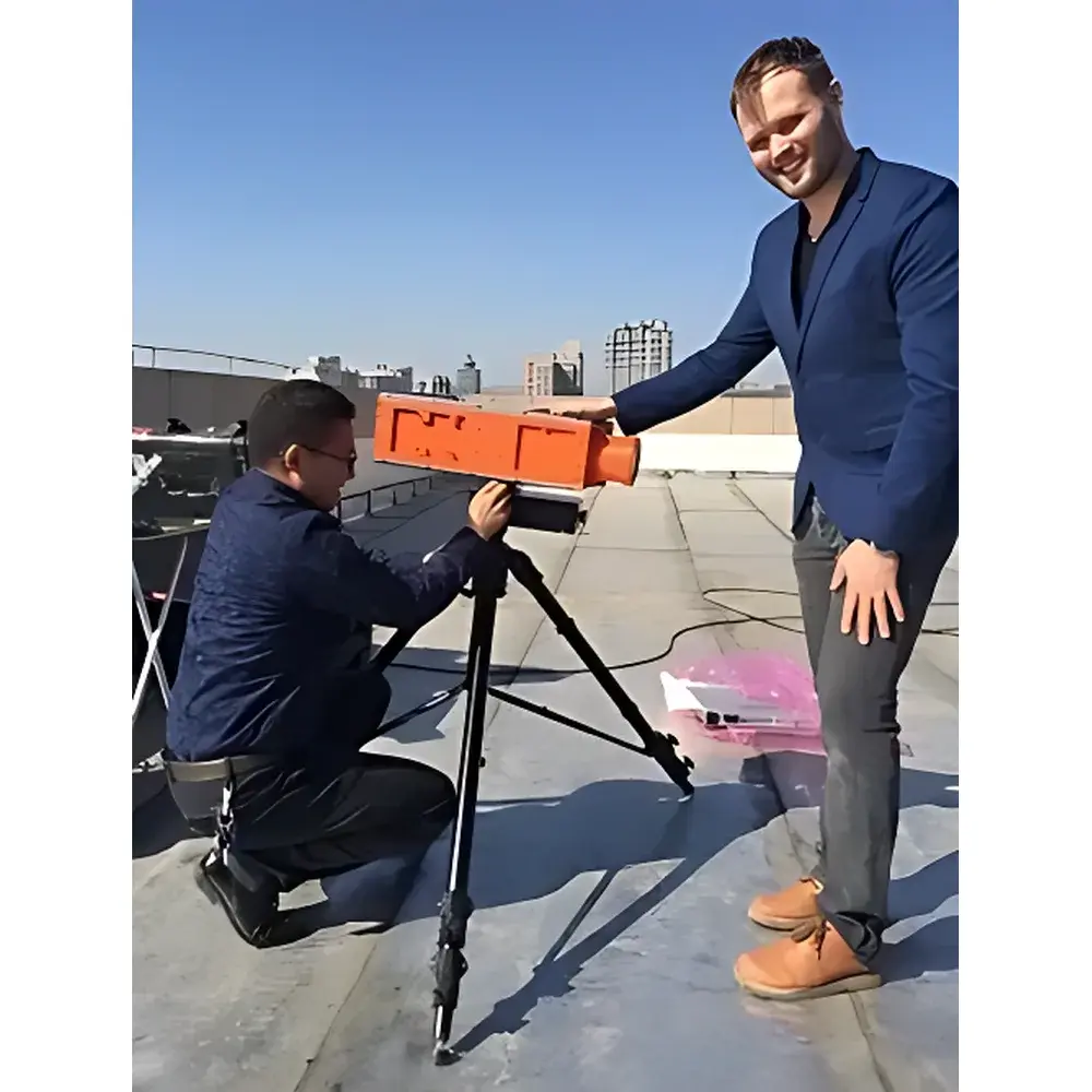
Yes—it is routinely deployed on tripod-mounted near-surface platforms, instrumented towers (e.g., ICOS sites), and fixed-wing aircraft; UAV integration requires custom gimbal stabilization and power management due to its 25 kg system mass.
Does AisaIBIS provide absolute SIF radiance values or only relative fluorescence yields?
When radiometrically calibrated and atmospherically corrected via the HyPlant chain, it delivers physically meaningful SIF radiance (µW·m−2·sr−1·nm−1) traceable to SI units—not merely normalized ratios.
Is real-time SIF mapping possible during flight?
No—real-time mapping is not supported; however, onboard storage enables post-mission processing with sub-pixel geolocation accuracy (<1 m GSD at 1000 m altitude) and reproducible SIF retrieval across multi-temporal campaigns.
How does AisaIBIS handle cloud variability during airborne acquisition?
Its high frame rate and narrow spectral sampling allow temporal averaging across multiple frames per ground pixel, mitigating transient irradiance fluctuations; cloud screening is applied during Level 2 processing using co-registered RGB or thermal data.