Top Cloud-agri TPGSQ-4 Tube-type Soil Moisture and Temperature Profiling Monitor
| Brand | Top Cloud-agri |
|---|---|
| Origin | Zhejiang, China |
| Manufacturer Type | Manufacturer |
| Country of Origin | Domestic (China) |
| Model | TPGSQ-4 |
| Instrument Category | Soil Moisture / Water Potential Analyzer |
| Protection Rating | IP67 |
| Housing Material | PVC |
| Communication Options | 4G/2G cellular, RS485 (≥100 m) |
| Power Supply | Solar panel, AC 220 V, or long-life internal Li-ion battery |
| GPS Integration | Yes, real-time geolocation reporting |
| Vibration Detection | Integrated accelerometer for tamper alerting |
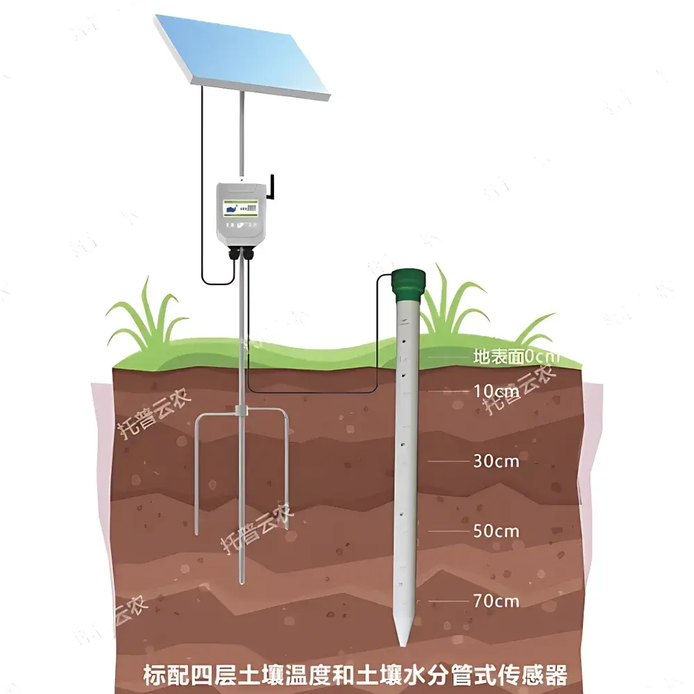
| Sensor Configuration | Standard 4-layer soil moisture & temperature profiling |
| Measurement Depth | Up to 70 cm (customizable beyond 70 cm) |
| Layer Spacing | Minimum 10 cm |
| Moisture Range | 0–100% volumetric water content (VWC) |
| Moisture Accuracy | ±3% VWC (factory-calibrated, no field recalibration required) |
| Temperature Range | −20 °C to +70 °C |
| Temperature Accuracy | ±0.5 °C |
| Data Logging Interval | Configurable from 5 minutes to 12 hours |
| Data Export | CSV, Excel via web platform or USB |
| Cloud Platform | Proprietary C/S architecture with web and mobile (iOS/Android) interfaces |
| Data Security | Local backup + cloud redundancy, audit-ready export logs |
| Software Updates | Over-the-air (OTA) supported |
Overview
The Top Cloud-agri TPGSQ-4 Tube-type Soil Moisture and Temperature Profiling Monitor is an in-situ, multi-depth environmental sensing system engineered for continuous, high-reliability soil hydric characterization in unattended field deployments. Based on time-domain transmission (TDT) principles—validated against ASTM D5792 and ISO 11274 protocols—the instrument delivers volumetric water content (VWC) and soil temperature measurements at discrete, user-defined depth intervals within a single vertically installed probe tube. Unlike point-sensor arrays requiring multiple boreholes, the TPGSQ-4 integrates four calibrated dielectric sensors along a sealed, rigid PVC column, enabling synchronized, co-located profiling from surface to 70 cm (extendable upon request). Its robust IP67-rated housing and low-power architecture support year-round operation in agricultural fields, forested slopes, irrigation districts, and landslide-prone terrain—providing foundational data for drought early-warning systems, precision irrigation scheduling, hydrological modeling, and climate-resilient land management.
Key Features
- Hermetically sealed PVC probe tube with IP67 ingress protection, rated for permanent burial in saturated, saline, or freeze-thaw environments.
- Factory-calibrated 4-layer sensor stack measuring VWC and temperature simultaneously at configurable depths (minimum 10 cm inter-sensor spacing; max standard depth: 70 cm).
- Integrated GPS module delivering real-time latitude/longitude coordinates with each data packet—critical for spatial metadata integrity in GIS-integrated monitoring networks.
- Vibration-detection circuitry triggers immediate push alerts to designated mobile endpoints upon unauthorized physical disturbance—supporting asset security in remote deployment zones.
- Dual-mode communication: LTE-M/NB-IoT or legacy 2G cellular uplink (fallback), plus optional RS485 interface for local wired telemetry over distances exceeding 100 meters.
- Triple power architecture: compatible with solar charging kits (with MPPT controller), grid-supplied 220 V AC adapters, or internal long-cycle lithium-ion batteries (>12 months operational life at 30-min logging interval).
- Fully open RESTful API and Modbus RTU protocol support—enabling seamless integration into third-party SCADA platforms, farm management software (e.g., Granular, Climate FieldView), or national agro-meteorological databases.
Sample Compatibility & Compliance
The TPGSQ-4 is validated for use across mineral soils (sandy loam to clay), organic-rich topsoils, and disturbed anthropogenic substrates—including reclaimed mining sites and urban green infrastructure. It complies with GB/T 28410–2012 (Chinese national standard for soil moisture sensors) and aligns with FAO-recommended practices for in-situ profile monitoring. While not certified to IEC 61326-1 (EMC) or UL 61010-1 out-of-box, its electrical design meets CE EMC Directive 2014/30/EU when deployed with approved power and communication modules. Data traceability supports GLP-aligned workflows: each measurement record includes timestamp (UTC), sensor ID, GPS coordinates, battery voltage, signal quality index, and firmware version—facilitating audit readiness per ISO/IEC 17025 laboratory accreditation requirements.
Software & Data Management
The proprietary Top Cloud-agri Instrument Cloud Platform operates as a secure, multi-tenant SaaS environment accessible via HTTPS-encrypted web browsers or native iOS/Android applications. All raw sensor data are ingested with immutable timestamps and stored redundantly across geodistributed servers. The platform provides role-based access control (RBAC), customizable dashboards, automated anomaly detection (e.g., sudden VWC drop indicating leakage or sensor failure), and scheduled report generation (daily/weekly/monthly PDF/Excel summaries). Historical datasets can be exported in CSV, NetCDF, or GeoJSON formats—with spatial attributes preserved for QGIS or ArcGIS import. Audit logs capture all user actions (login, configuration change, export event) for compliance with FDA 21 CFR Part 11 electronic record requirements where applicable. Firmware updates are delivered OTA with version rollback capability and pre-deployment validation checks.
Applications
- Drought Resilience Monitoring: Real-time VWC gradients inform regional drought severity indices (e.g., USDM equivalents) and trigger automated irrigation advisories.
- Smart Irrigation Control: Integration with variable-rate irrigation controllers enables dynamic water application based on root-zone depletion thresholds.
- Landslide Risk Assessment: Co-located moisture–temperature profiles detect saturation fronts preceding slope instability—deployed in catchment-scale early-warning networks.
- Soil Carbon Research: Long-term VWC–temperature covariance analysis supports process-based modeling of microbial respiration and SOC mineralization rates.
- Agricultural Yield Forecasting: Coupled with phenological models, soil water status data improve seasonal yield prediction accuracy for maize, rice, and wheat cropping systems.
- Ecological Restoration: Monitors rehydration dynamics in degraded grasslands or afforested areas, validating restoration success metrics under evolving climate conditions.
FAQ
What calibration is required before field deployment?
No user calibration is needed. Sensors undergo factory calibration against gravimetric reference standards across the full 0–100% VWC range and temperature spectrum. Certificate of Conformance (CoC) and calibration report are supplied with each unit.
Can the probe be installed in rocky or compacted soils?
Installation requires augering or hydraulic pushing; a 60 mm diameter pilot hole is recommended. For stony soils, optional stainless-steel guide rods and vibration-assisted insertion tools are available.
How is data security ensured during cellular transmission?
All 4G/2G transmissions use TLS 1.2 encryption. Device authentication employs unique X.509 certificates; no plaintext credentials are exchanged.
Is the cloud platform compliant with GDPR or CCPA?
Yes. Data residency options include EU-hosted instances. Personal data processing adheres to ISO/IEC 27001-certified infrastructure controls.
What maintenance is required over a 5-year service life?
Annual visual inspection of probe integrity and connector seals is recommended. Battery replacement (if used without solar) is required every 3–5 years depending on logging frequency and ambient temperature profile.
Related Products


