YellowScan Surveyor Ultra Airborne & Vehicle-Mounted Dual-Use LiDAR System
| Origin | Beijing, China |
|---|---|
| Manufacturer Type | Authorized Distributor |
| Origin Category | Domestic (PRC) |
| Model | YellowScan Surveyor Ultra |
| Pricing | Available Upon Request |
Overview
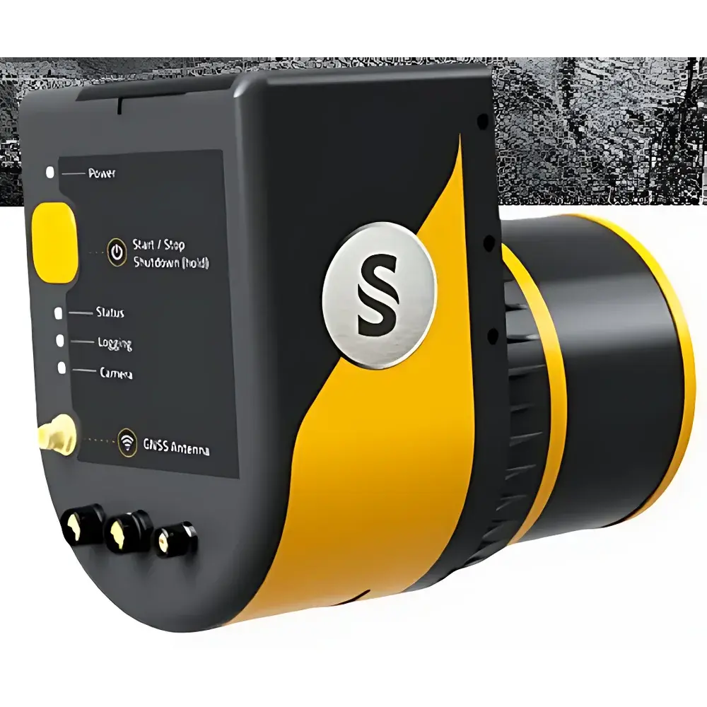
The YellowScan Surveyor Ultra is a dual-mode, high-integration LiDAR sensing platform engineered for simultaneous airborne and ground-based mobile mapping applications. It operates on the time-of-flight (ToF) principle, utilizing a Class 1 near-infrared laser (905 nm) to deliver precise 3D point cloud acquisition under variable environmental conditions. The system integrates a tightly coupled GNSS/IMU navigation unit—compliant with RTK-GNSS positioning standards—and a 360° horizontal field-of-view (FoV) rotating scanning mechanism, enabling full hemispherical coverage without mechanical tilting or external gimbals. Designed for operational flexibility, it supports both UAV integration (via standardized mounting interfaces and low-SWaP power requirements) and vehicle-mounted deployment (with shock-isolated chassis mounting and CAN/RS232 synchronization capabilities). Its architecture prioritizes metrological traceability, mechanical stability, and thermal drift compensation—critical for repeatable topographic change detection and long-duration survey campaigns.
Key Features
- True dual-platform compatibility: Certified for integration with multirotor and fixed-wing UAVs (e.g., Ecodrone® series), as well as terrestrial mobile mapping platforms including SUVs, ATVs, and rail-mounted carriers.
- High-density point cloud generation: Up to 1.2 million points per second (pps) at 100 Hz scan frequency, supporting sub-centimeter vertical precision (RMS ≤ 15 mm) and horizontal accuracy ≤ 30 mm (1σ, with RTK-GNSS correction).
- Robust inertial navigation: Embedded tactical-grade IMU (gyro bias instability < 5°/hr, accelerometer ARW < 0.05 mg/√Hz) fused with dual-frequency GNSS receiver (L1/L2/L5 bands) for continuous PVT solution during GNSS outages up to 60 seconds.
- Lightweight and modular design: Total system mass < 2.8 kg (including GNSS antenna and IMU), IP54-rated enclosure, and MIL-STD-810G compliant vibration/shock resistance.
- Onboard real-time georeferencing: Raw point cloud output includes fully calibrated XYZ coordinates, intensity, return number, and GPS time stamps—no post-processing required for basic geo-registration.
Sample Compatibility & Compliance
The Surveyor Ultra is validated for use across heterogeneous terrain types—including forest canopies, agricultural fields, steep-slope mine faces, urban infrastructure, and archaeological earthworks—without hardware modification. Its 905 nm wavelength ensures optimal signal penetration through moderate foliage while maintaining eye safety (IEC 60825-1:2014 Class 1 certified). The system conforms to ISO 19115 metadata standards for geospatial data interoperability and supports export of LAS/LAZ, E57, and ASCII formats compatible with industry-standard processing pipelines (e.g., TerraSolid, CloudCompare, OPALS). For regulated environments, raw sensor logs and IMU/GNSS synchronization timestamps are retained for GLP-compliant audit trails; firmware versioning and configuration parameters are logged per acquisition session in accordance with ISO/IEC 17025 documentation requirements.
Software & Data Management
Data acquisition is managed via YellowScan’s proprietary Surveyor Control Software (v4.2+), which provides real-time point cloud visualization, flight plan import (KML/KMZ), IMU health monitoring, and automatic mission abort triggers based on GNSS fix quality or IMU saturation thresholds. All raw data—including laser echoes, IMU raw measurements, and GNSS observables—are stored on removable microSD cards (up to 512 GB) with timestamp-synchronized file naming. Post-processing leverages YellowScan’s Georeferencing Engine (YGE), supporting PPP and RTK corrections from NTRIP/CORS networks. Export workflows comply with USGS NGDA and ESA Copernicus data packaging conventions. Audit logs record operator ID, system calibration status (last verified date), and firmware revision—enabling traceability under FDA 21 CFR Part 11 and EU Annex 11 requirements when deployed in environmental compliance monitoring contexts.
Applications
- Forestry & Carbon Stock Assessment: Canopy height modeling (CHM), individual tree detection (ITD), and biomass estimation using discrete-return point clouds with ≥3 returns per pulse.
- Agricultural Phenotyping: Crop height variation analysis, canopy volume quantification, and NDVI-LiDAR fusion for stress detection in high-throughput field trials.
- Mine & Quarry Volume Monitoring: Stockpile volumetric change tracking with monthly repeatability < 0.3% (per ASTM D6534-20).
- Archaeological Topographic Mapping: Sub-meter detection of earthwork features beneath light vegetation cover, integrated with photogrammetric orthomosaics.
- Power Line Corridor Inspection: Conductor sag analysis, clearance verification against IEC 61936-1, and vegetation encroachment assessment using automated classification algorithms.
- Coastal & Fluvial Morphodynamics: High-temporal-resolution DEM differencing for erosion/accretion studies in intertidal zones (validated per ISO/TS 19130-2).
FAQ
Is the Surveyor Ultra compatible with non-YellowScan UAV platforms?
Yes—it supports standard MAVLink and UART protocols, and has been verified with DJI Matrice 300 RTK, Autel EVO Max 4T, and custom VTOL platforms via SDK integration.
What level of GNSS correction service is required to achieve published accuracy specs?
RTK-level correction (≥95% fix rate) from a local base station or NTRIP caster is mandatory; PPP-only operation degrades horizontal accuracy to ±15 cm (1σ).
Can the system operate in rain or fog?
It maintains functionality in light precipitation (<0.5 mm/hr) but experiences increased noise and range reduction in dense fog (visibility <50 m); no active weather compensation is implemented.
Does the system support multi-echo detection?
Yes—up to 5 returns per laser pulse, enabling robust understory and ground surface discrimination in vegetated environments.
Is firmware update capability available over-the-air?
No—updates require physical connection via USB-C and must be performed using YellowScan’s certified update utility to preserve calibration integrity.
Related Products


