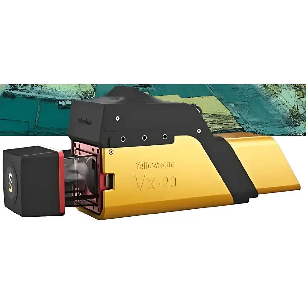
YellowScan Vx20 Series UAV-Mounted LiDAR System
| Origin | Beijing, China |
|---|---|
| Manufacturer Type | Authorized Distributor |
| Origin Category | Domestic (China) |
| Model | YellowScan Vx20 |
| Pricing | Upon Request |
Overview
The YellowScan Vx20 Series is a turnkey, high-precision UAV-mounted Light Detection and Ranging (LiDAR) system engineered for demanding geospatial and environmental remote sensing applications. Built around the RIEGL miniVUX-1UAV high-performance scanning LiDAR sensor and tightly integrated with the Applanix APX-20 UAV-grade inertial navigation system (INS), the Vx20 delivers sub-centimeter positional accuracy in point cloud generation—even at operational altitudes up to 100 meters above ground level (AGL). Its architecture follows the principle of direct georeferencing: real-time synchronization between LiDAR pulse timing, IMU angular rate data, and GNSS position fixes ensures rigorous geometric fidelity without reliance on extensive ground control points (GCPs). This makes the Vx20 particularly suited for applications requiring high-fidelity 3D structural characterization—such as forest canopy profiling, precision topographic modeling, and change detection over time-series deployments.
Key Features
- Direct georeferenced point cloud output with ≤2 cm horizontal and ≤3 cm vertical absolute accuracy (RMS) under optimal GNSS/IMU conditions
- Fully calibrated intensity values per return, enabling radiometric consistency across flights and cross-sensor comparability
- Integrated Applanix APX-20 INS providing dual-antenna GNSS + tactical-grade IMU, supporting PPP-RTK and post-processed kinematic (PPK) workflows
- Ruggedized, vibration-damped enclosure designed for extended operation on multirotor and fixed-wing UAV platforms
- Plug-and-play compatibility with Ecodrone® series UAVs, including seamless integration with hyperspectral imagers (e.g., Headwall Nano-Hyperspec), thermal cameras (e.g., FLIR Tau2), and multispectral sensors
- Onboard storage and real-time telemetry via Ethernet or serial interface; supports industry-standard protocols including NMEA 0183 and RTCM v3.x
Sample Compatibility & Compliance
The Vx20 system is compatible with a broad range of commercial and research-grade UAV platforms, including but not limited to DJI Matrice 300 RTK, Freefly Systems ALTA X, and custom-built VTOL airframes meeting payload capacity (>2.5 kg) and power delivery (>24 V DC, ≥5 A continuous) specifications. It complies with CE, FCC Part 15, and RoHS directives for electromagnetic compatibility and environmental safety. While the system itself does not fall under FDA or ISO 13485 regulatory scope, its output data—when used in environmental monitoring or land surveying contexts—meets the geometric integrity requirements of ISO 19115 (Geographic Information Metadata), ASTM E2847 (Standard Practice for Geospatial Data Quality), and national mapping standards (e.g., USGS National Map Accuracy Standards). All firmware and calibration certificates are traceable to NIST-traceable references.
Software & Data Management
Data acquisition is managed through YellowScan’s proprietary GeoTagger software, which enables real-time quality assurance checks—including laser pulse density monitoring, scan angle distribution analysis, and GNSS fix status visualization. Raw point clouds are exported in standard LAS/LAZ formats compliant with ASPRS v1.4 specification. Post-processing leverages Applanix POSPac MMS for high-accuracy PPK/PPP trajectory refinement and optional integration with third-party tools such as Terrasolid TerraScan, CloudCompare, or QGIS with LAStools plugins. The system supports full audit trails for processing parameters, adhering to GLP-aligned documentation practices where required for environmental reporting or regulatory submissions.
Applications
- Forest structure analysis: individual tree crown delineation, biomass estimation, and understory penetration assessment using multi-return capability
- Agricultural phenotyping: crop height modeling, canopy volume quantification, and nitrogen stress mapping when fused with hyperspectral indices
- Mine site volumetric monitoring: stockpile volume calculation, pit wall stability assessment, and progressive reclamation verification
- Archaeological landscape reconstruction: detection of subtle earthworks and buried features beneath vegetation canopies
- Power line corridor inspection: conductor sag analysis, vegetation encroachment detection, and tower foundation settlement tracking
- Coastal and fluvial geomorphology: dune migration studies, riverbank erosion quantification, and floodplain DEM generation
FAQ
What is the maximum recommended flight altitude for maintaining Vx20’s specified accuracy?
The system maintains its published accuracy specifications up to 100 m AGL under favorable GNSS multipath conditions and with ≥10 satellite visibility.
Does the Vx20 support multiple returns per pulse?
Yes—it captures up to 15 discrete returns per laser pulse, enabling robust penetration through vegetation layers.
Is factory recalibration required after transport or mechanical shock?
The system includes built-in boresight calibration routines; however, periodic verification against known control targets is recommended every 6 months or after significant impact events.
Can the Vx20 be operated in PPK mode only—without real-time GNSS correction?
Yes. The APX-20 records raw GNSS observables and IMU data onboard, allowing fully offline PPK processing with base station data.
What file formats are natively supported for intensity calibration metadata?
Calibrated intensity values are embedded directly in LAS header fields (e.g., “Intensity” and “Extended Return Number”) and accompanied by JSON-formatted calibration reports detailing gain/offset coefficients and temperature compensation models.


