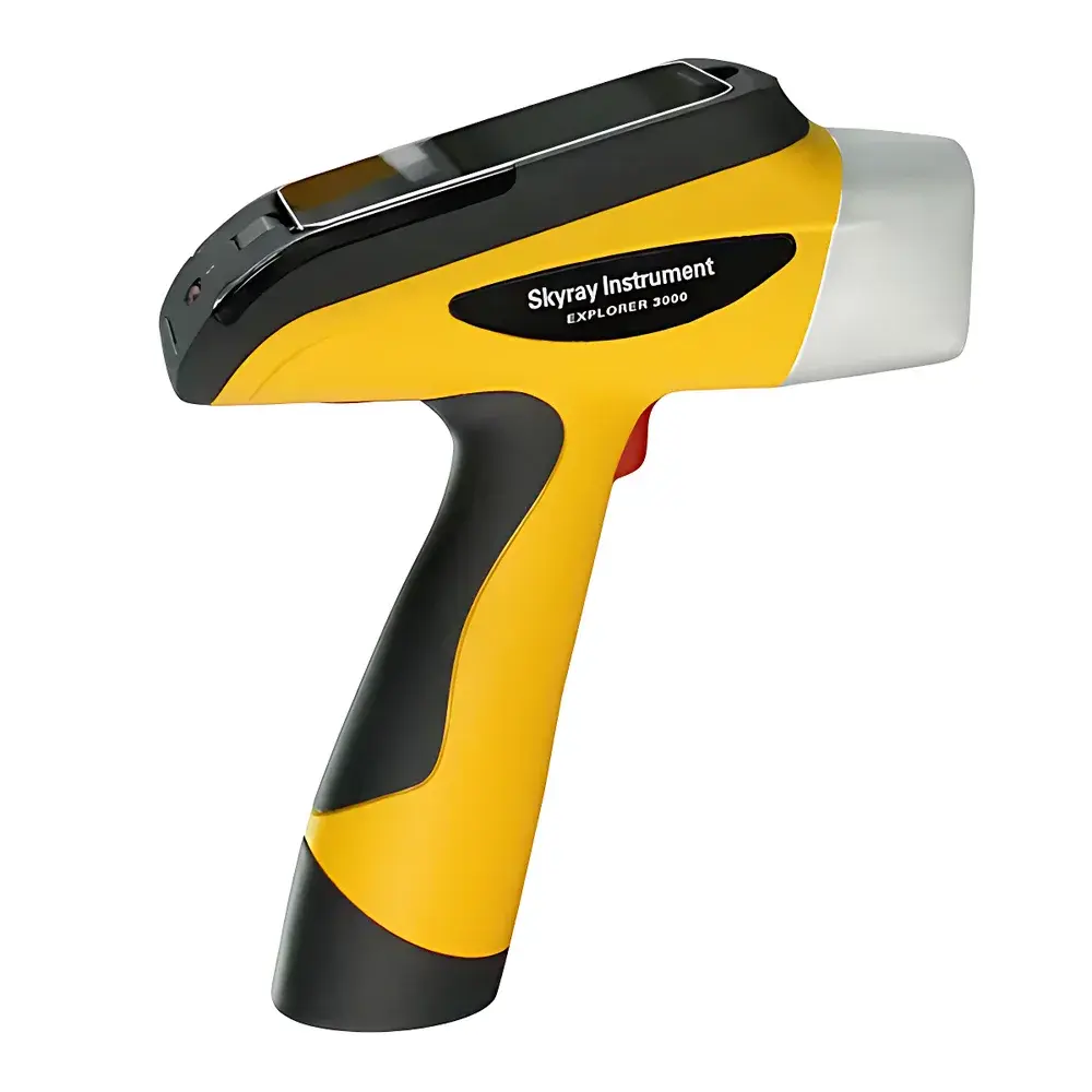
SkyRay Instrument Explorer 7000 Portable Energy Dispersive X-Ray Fluorescence (ED-XRF) Spectrometer for Geological and Mining Applications
| Brand | SkyRay Instrument |
|---|---|
| Origin | Jiangsu, China |
| Manufacturer Type | OEM Manufacturer |
| Country of Origin | China |
| Model | Explorer 7000 |
| Application | Handheld/Portable |
| Industry-Specific Use | Geology & Mineral Exploration |
| Detector | Fast Silicon Drift Detector (SDD) |
| Excitation Source | Micro-focus X-ray Tube |
| Light Element Capability | Mg (12) to U (92) |
| Operating Mode | Direct Surface Analysis (No Sample Preparation Required) |
| GPS Integration | Built-in GNSS Receiver (GPS + GLONASS + BeiDou) |
| Data Storage | Internal High-Capacity Flash Memory |
| Battery | Rechargeable 27,000 mAh Li-ion (Up to 72 h continuous operation) |
| Display | 5-inch Rotatable HD Touchscreen (270° rotation, multi-touch enabled) |
| Environmental Rating | IP54 (Dust and Splash Resistant) |
| Safety | Triple Interlock System, Real-time LED Status Indicator, Automatic Beam Shutter |
Overview
The SkyRay Instrument Explorer 7000 is a field-deployable, handheld energy dispersive X-ray fluorescence (ED-XRF) spectrometer engineered for rapid, non-destructive elemental analysis of geological materials in situ. Based on fundamental XRF physics—where primary X-rays from a micro-focus tube excite characteristic secondary (fluorescent) X-rays from sample atoms—the Explorer 7000 quantifies elemental composition from magnesium (Mg, Z=12) through uranium (U, Z=92) without chemical digestion or pelletization. Its optimized optical path eliminates the need for helium purging, enabling reliable light-element detection in ambient air—a critical advantage for field-based ore grade estimation, lithological mapping, and environmental soil screening. Designed for geologists, exploration teams, and mine site QA/QC personnel, the instrument delivers laboratory-grade precision in a ruggedized, ergonomic form factor suitable for extended use across remote terrains.
Key Features
- Fast SDD detector with high count-rate capability (>500 kcps effective spectral throughput) and excellent energy resolution (<140 eV at Mn Kα), ensuring accurate peak deconvolution in complex mineral matrices.
- Digital multi-channel analyzer (MCA) architecture with real-time spectrum processing, enabling adaptive dead-time correction and improved signal-to-noise ratio over analog systems.
- Integrated GNSS module (GPS/GLONASS/BeiDou) providing sub-5-meter positional accuracy; geotagged spectra are automatically embedded with latitude, longitude, and altitude metadata for GIS-compatible reporting.
- 8-megapixel coaxial camera aligned with the X-ray beam axis, allowing precise targeting of mineral veins, alteration halos, or heterogeneous surfaces prior to measurement.
- Triple safety interlock system: hardware-triggered beam shutter, thickened collimator housing, and mechanical safety hood—fully compliant with IEC 62495 and national radiation safety regulations (GBZ 188-2014).
- Rotatable 5-inch capacitive touchscreen with anti-glare coating and glove-compatible touch response, operable under direct sunlight or low-temperature conditions (-10°C to 50°C).
- IP54-rated sealed enclosure with shock-absorbing polymer casing and reinforced grip handle—validated for drop resistance up to 1.2 m onto concrete per MIL-STD-810G.
Sample Compatibility & Compliance
The Explorer 7000 supports direct analysis of unprepared solid samples including drill cores, rock chips, outcrop surfaces, mine tailings, and processed concentrates. Its collimated beam (3 mm diameter standard) minimizes matrix effects from irregular topography, while built-in intensity correction algorithms compensate for variable surface geometry and density heterogeneity. The instrument meets ISO 18557:2016 for field-portable XRF performance validation and supports traceability under GLP and ISO/IEC 17025 frameworks. Software audit trails—including user login, method selection, calibration history, and raw spectrum export—fulfill documentation requirements for ASTM D6440 (soil metals), ASTM E2857 (ore assay), and USP / elemental impurities guidance where applicable.
Software & Data Management
Preloaded SkyRay GeoAnalyzer™ software features dual operating modes: User Mode for one-touch ore type classification (e.g., “Bauxite”, “Laterite”, “Porphyry Cu-Mo”) and Expert Mode for custom curve development, multi-element quantification, and matrix-matched calibration using certified reference materials (CRMs). All spectral data are stored in vendor-neutral .spc format with embedded metadata (time stamp, GPS coordinates, operator ID, measurement duration). Internal storage capacity exceeds 100,000 spectra; optional Bluetooth 5.0 connectivity enables wireless transfer to ruggedized thermal printers or secure enterprise servers. Firmware updates and method libraries are delivered via encrypted USB or OTA (over-the-air) protocols, maintaining version control and regulatory alignment.
Applications
- Real-time grade control during open-pit or underground mining operations—monitoring feed, concentrate, and tailings streams for Fe, Cu, Ni, Zn, Pb, Au, and REEs.
- Exploration geochemistry: rapid reconnaissance of anomalous zones in soil, stream sediment, or regolith; identification of pathfinder elements (e.g., As, Sb, Bi) associated with concealed deposits.
- Mine closure and rehabilitation: longitudinal monitoring of As, Cd, Cr, Pb, and Hg concentrations in reclaimed soils against regulatory thresholds (e.g., EU Soil Framework Directive, US EPA Region 10 standards).
- Mineral processing optimization: evaluating liberation efficiency by comparing elemental distributions across size fractions or flotation stages.
- Regulatory compliance testing: screening for restricted heavy metals in construction aggregates, recycled fill material, and industrial by-products per EN 12457 or TCLP protocols.
FAQ
Does the Explorer 7000 require sample preparation before analysis?
No. It performs direct, non-destructive analysis on solid surfaces without grinding, pressing, or acid digestion.
Can it detect light elements such as magnesium and aluminum reliably in field conditions?
Yes. Its ultra-short excitation path and vacuum-free air-path design enable consistent Mg–P detection without helium flushing or vacuum pumping.
Is the GPS data synchronized with each spectrum file?
Yes. Latitude, longitude, altitude, date/time, and satellite fix quality are embedded into every exported spectrum and report.
How is data integrity maintained for audit purposes?
All measurements include immutable timestamps, operator IDs, calibration logs, and full raw spectra—supporting 21 CFR Part 11-compliant electronic records when deployed with validated IT infrastructure.
What safety certifications does the instrument hold?
It complies with IEC 62495 (radiation safety for portable XRF), GBZ 188-2014 (Chinese occupational exposure limits), and carries CE marking for electromagnetic compatibility (EMC) and low-voltage directive (LVD) conformity.