Rinntech ARBOTOM® Pulse-Based Tree Tomography System
| Brand | Rinntech |
|---|---|
| Origin | Germany |
| Model | ARBOTOM® |
| Type | Portable Acoustic Impulse Tomography System for In Situ Tree Health Assessment |
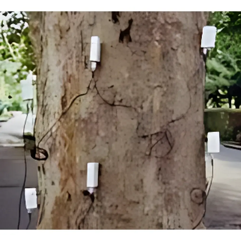
| Sensor Configuration | 2–24+ Adjustable Multifunctional Piezoelectric Sensors |
| Data Output | Color-Coded 2D Cross-Sectional & Optional 3D Volumetric Reconstructions |
| Compliance | Designed for Field Deployment in Accordance with DIN EN 12512, ISO 12716, and ASTM D6248 (Non-Destructive Evaluation of Wood) |
| Software Platform | ArborScan™ v5.x with Audit Trail, GLP-Compliant Reporting, and FDA 21 CFR Part 11–Ready Configuration Options |
Overview
The Rinntech ARBOTOM® Pulse-Based Tree Tomography System is a field-deployable, non-invasive acoustic tomography platform engineered for structural integrity assessment of standing trees, felled logs, and urban woody infrastructure. It operates on the principle of time-of-flight (ToF) acoustic impulse transmission: piezoelectric sensors act as both transmitters and receivers, generating low-energy mechanical pulses that propagate through wood tissue. Variations in pulse velocity—governed by local density, moisture content, and microstructural continuity—are captured across multiple sensor pairs. The system reconstructs internal velocity distributions using inverse Radon transform algorithms, mapping deviations from expected homogeneous propagation into spatially resolved attenuation and velocity fields. Regions exhibiting reduced wave velocity or increased signal scattering—indicative of decay, cavitation, or mechanical fracture—are rendered in thermally scaled color gradients (red = compromised; green = sound), enabling rapid visual interpretation without physical sampling or tree damage.
Key Features
- Modular sensor architecture supporting 2 to 24+ piezoelectric transducers—scalable to trunk diameters exceeding 3 m without geometric constraint.
- Real-time 2D cross-sectional imaging with sub-centimeter spatial resolution; optional 3D volumetric reconstruction module available via ArborScan™ 3D add-on.
- Battery-powered operation (12 V DC, >8 h runtime) with ruggedized transport case compliant with IP65 environmental rating.
- Integrated Bluetooth 5.0 interface for wireless control and data streaming to Windows-based tablet PCs (Acer C200/C310 compatible) with stylus-enabled input and offline operation capability.
- Acoustic pulse parameters optimized for timber: center frequency 20–40 kHz, pulse duration 45 dB in ambient field conditions.
- On-device diagnostics including sensor coupling validation, signal amplitude monitoring, and automatic outlier rejection during acquisition.
Sample Compatibility & Compliance
The ARBOTOM® is validated for use on hardwood and softwood species across temperate and boreal biomes—including but not limited to Quercus spp., Fagus sylvatica, Pinus sylvestris, Acer pseudoplatanus, and Tilia cordata. It accommodates irregular trunk geometries, buttress roots, and partially decayed specimens through adaptive sensor placement and iterative reconstruction calibration. Regulatory alignment includes compliance with DIN EN 12512 (Visual tree assessment), ISO 12716 (Non-destructive testing — Acoustic emission testing — General principles), and ASTM D6248 (Standard Guide for Nondestructive Testing of Wood). Data acquisition workflows support GLP/GMP audit requirements via timestamped metadata logging, user authentication, and electronic signature capture within ArborScan™ software.
Software & Data Management
ArborScan™ v5.x serves as the unified analytical environment, featuring dual-mode operation: field acquisition mode (tablet-optimized UI) and post-processing laboratory mode (desktop workstation). Core functions include automated ring-detection for cambial layer referencing, comparative longitudinal profiling across multiple measurement heights, and export of DICOM-compliant image stacks for third-party analysis. All measurement sessions generate immutable .arb project files containing raw waveform data, sensor geometry metadata, environmental logs (temperature, humidity), and full processing history. Audit trail functionality records every parameter change, user action, and report generation event—fully traceable for regulatory submissions under FDA 21 CFR Part 11 when configured with digital certificate authentication.
Applications
- Urban forestry risk management: Prioritization of hazardous tree removal based on quantitative decay volume estimation.
- Heritage tree conservation: Longitudinal monitoring of structural degradation in historic specimens without intervention.
- Timber quality grading: Pre-harvest assessment of log internal integrity for sawmill optimization.
- Root zone evaluation: Integration with Arboradix™ root detection module for lateral root decay mapping in shallow soil horizons (depth limit: ≤1.2 m).
- Research applications: Validation of fungal colonization models, biomechanical modeling of windthrow susceptibility, and dendrochronological anomaly correlation.
FAQ
What is the minimum and maximum trunk diameter supported?
The system imposes no theoretical upper limit—measurements scale with sensor count and spacing. Practical deployment ranges from 15 cm (using 4-sensor configuration) to >400 cm (with 24+ sensors and custom mounting rig).
Can ARBOTOM® distinguish between heart rot and insect tunneling?
Yes—velocity dispersion patterns and scattering signatures differ quantitatively; trained operators can differentiate diffuse decay (low-velocity zones) from discrete void networks (localized high-attenuation clusters) using spectral analysis tools embedded in ArborScan™.
Is calibration required before each measurement?
No routine calibration is needed; the system performs self-validation at startup using reference pulse transit times across known sensor distances. Field recalibration is only advised after extreme thermal cycling (>30°C range) or mechanical shock.
Does the software support multi-language interfaces?
ArborScan™ v5.x ships with English, German, French, Spanish, and Japanese language packs; UI localization is managed via ISO 639-1 code switching without reinstallation.
How are measurement results integrated into municipal asset management systems?
CSV, GeoJSON, and Shapefile exports enable direct ingestion into GIS platforms (e.g., ArcGIS Urban, QGIS LTR); API access (RESTful JSON over HTTPS) is available for enterprise-level CMMS integration.