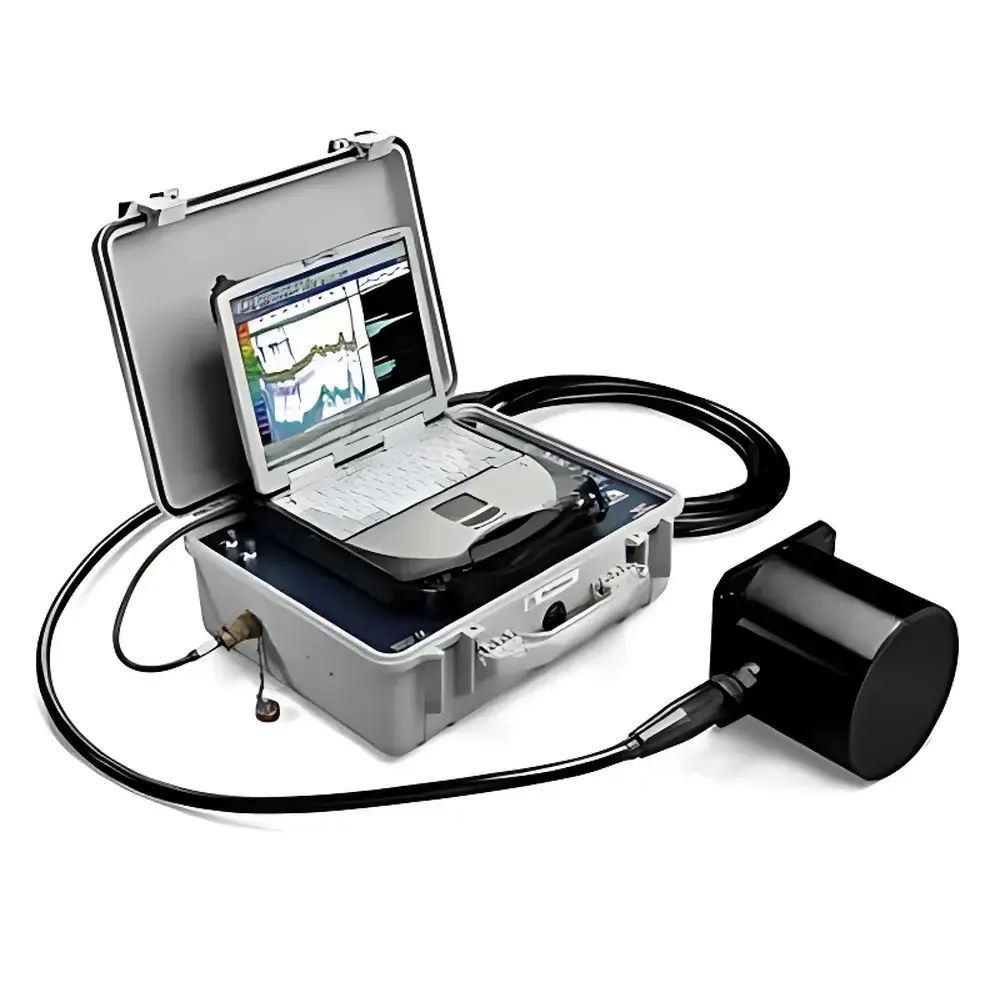
Biosonics DT-X Digital Scientific Echosounder
| Brand | Biosonics |
|---|---|
| Origin | USA |
| Model | DT-X |
| Detection Principle | Pulse-echo ultrasonic backscatter and scattering |
| Frequency Range | 38, 70, 120, 200, 420, 1000 kHz |
| Dynamic Range | >160 dB |
| Minimum Detectable Echo Level | –140 dB |
| Pulse Repetition Rate | 0.01–30 Hz |
| Pulse Width | 0.1–1 ms |
| Maximum Detection Range | 0–1000 m |
| Transmitter Power | 100–1000 W RMS |
| Beam Configuration | Single-beam and split-beam transducer support (up to 4 simultaneously) |
| Transducer Housing | Anodized aluminum or stainless steel |
| Onboard Processing | Linux-based programmable embedded processor |
| Integrated Differential GPS | Yes |
| Data Output Format | Raw digital echo data, time-series SV/TS profiles, georeferenced .csv/.bin/.ech |
| Software Suite | Visual Analyzer (fish), EcoSAV (submerged aquatic vegetation), Sediment Profiler (substrate & bathymetry) |
| Power Input | 85–264 V AC / 10–14 V DC |
| Power Consumption | 30 W |
| Host Dimensions | 49 × 39 × 19 cm |
| Host Weight | 13.6 kg |
| Transducer Dimensions | Ø18 × 17 cm |
| Transducer Weight | 4 kg |
| Cable Length | 8–160 m (digital signal) |
Overview
The Biosonics DT-X Digital Scientific Echosounder is a high-fidelity, multi-frequency pulse-echo hydroacoustic platform engineered for quantitative aquatic ecosystem assessment. Unlike conventional thickness gauges or industrial ultrasonic sensors, the DT-X operates on marine-grade scientific echosounding principles—transmitting precisely calibrated acoustic pulses into water columns and analyzing time-resolved backscattered energy from biological targets (e.g., fish, zooplankton), submerged macrophytes, sediment interfaces, and seabed substrates. Its core architecture integrates digitally sampled echo waveforms at the transducer level—eliminating analog signal degradation—and supports concurrent operation of up to four independently configured transducers across frequencies from 38 kHz to 1000 kHz. This enables simultaneous, co-registered measurements of fish biomass distribution, submerged aquatic vegetation (SAV) canopy height and percent cover, bathymetric topography, and substrate classification—all traceable to ISO 17677-1 (hydroacoustic survey standardization) and aligned with ASTM D6429 (field methods for aquatic habitat characterization). Designed for deployment from research vessels, autonomous platforms, or fixed monitoring stations, the DT-X delivers real-time, GIS-ready datasets compatible with QGIS, ArcGIS, and MATLAB-based post-processing workflows.
Key Features
- Digital transducer technology: Full waveform digitization at the sensor head ensures preservation of phase, amplitude, and spectral fidelity—critical for target strength (TS) calibration and species discrimination.
- Multi-frequency flexibility: Selectable center frequencies (38, 70, 120, 200, 420, 1000 kHz) allow optimization for target size, water clarity, and depth range—e.g., 38 kHz for deep-lake pelagic fish surveys; 420 kHz for shallow-water SAV structural profiling.
- Split-beam and single-beam compatibility: Split-beam transducers enable individual target tracking, precise TS estimation, and angular position resolution (±0.5°); single-beam variants provide high-SNR bathymetry and substrate layering analysis.
- Embedded Linux processing unit: Onboard real-time echo integration, gain compensation, noise filtering, and raw data buffering reduce reliance on external computing and ensure deterministic latency.
- Integrated differential GPS: Sub-meter horizontal accuracy (SBAS/WAAS-enabled) provides georeferenced echo logs essential for spatially explicit ecological modeling and regulatory reporting (e.g., USACE Section 404 permit assessments).
- Ruggedized marine interface: IP67-rated host enclosure with MIL-STD-810G-compliant shock/vibration resistance and capacitive touchscreen operation under wet, low-light conditions.
Sample Compatibility & Compliance
The DT-X is validated for use in freshwater, brackish, and marine environments—including turbid reservoirs, eutrophic lakes, estuarine channels, and continental shelf zones. Its transducer beam patterns meet ANSI/ASA S1.10-2014 standards for directional response uniformity (< ±1 dB variation within main lobe), and side-lobe suppression is maintained at ≤ –35 dB—minimizing off-axis contamination in mixed-target scenarios. The system complies with IEC 62236-3-2 (EMC for marine electronics), FCC Part 15 Class B, and CE Directive 2014/53/EU. For regulated environmental monitoring, raw echo files retain full audit trails (timestamp, GPS fix, transducer ID, gain settings), satisfying GLP/GMP data integrity requirements per FDA 21 CFR Part 11 when paired with validated acquisition software (Visual Analyzer v6.5+, EcoSAV v4.2+).
Software & Data Management
Three domain-specific analysis modules are supplied with validated algorithms: Visual Analyzer (fish abundance, length-frequency distributions, vertical migration metrics), EcoSAV (SAV presence/absence mapping, canopy height interpolation via echo amplitude attenuation models), and Sediment Profiler (layer-thickness estimation, acoustic impedance contrast classification of sand/mud/gravel). All modules export metadata-embedded NetCDF4 files compliant with IOOS NetCDF Climate and Forecast (CF) conventions. Data synchronization supports NMEA 0183 and NMEA 2000 protocols for integration with CTDs, ADCPs, and fluorometers. Internal 128 GB SSD storage enables >100 hours of continuous dual-frequency logging at 20 Hz PRF; external USB 3.0 or Ethernet transfer maintains >40 MB/s sustained throughput.
Applications
- Fisheries science: Stock assessment surveys, entrainment risk evaluation at hydropower intakes, predator-prey spatial overlap quantification.
- Aquatic vegetation ecology: Long-term SAV recovery monitoring post-dredging, invasive species spread tracking (e.g., Hydrilla verticillata), light-attenuation modeling inputs.
- Sediment dynamics: Thickness mapping of recent depositional layers, identification of erosion-scour features, pre-/post-construction baseline comparisons for dredging permits.
- Habitat equivalency analysis: Integration with benthic grab sampling and side-scan sonar for EPA Region 5 Habitat Equivalency Analysis (HEA) frameworks.
- Regulatory compliance: Supporting NMFS Essential Fish Habitat (EFH) designations, USACE Nationwide Permit 27 reporting, and EU Water Framework Directive (WFD) ecological status assessments.
FAQ
Can the DT-X operate in both freshwater and seawater?
Yes—the transducers are pressure-compensated and corrosion-resistant (anodized aluminum or 316 stainless steel); frequency selection guidelines account for sound speed differences and absorption coefficients across salinity gradients.
Is split-beam transducer support mandatory for fish studies?
No—single-beam configurations suffice for biomass estimation and distribution mapping; however, split-beam is required for individual target counting, precise TS-derived length estimation, and behavioral trajectory reconstruction.
How does the DT-X ensure data traceability for regulatory submissions?
Every echo record includes embedded UTC timestamps, DGPS coordinates, transducer serial number, gain/PRF/pulse width settings, and firmware revision—enabling full forensic reconstruction of acquisition conditions per ISO/IEC 17025 clause 7.5.2.
What navigation interfaces are supported?
NMEA 0183 (GGA, VTG, RMC), NMEA 2000 (PGN 129025, 129026), and proprietary UDP streaming for third-party INS/IMU fusion.
Are software updates provided post-purchase?
Yes—Biosonics offers free minor version updates and paid major releases with new algorithm modules; all software is validated against NIST-traceable acoustic phantoms and field intercomparison datasets.


