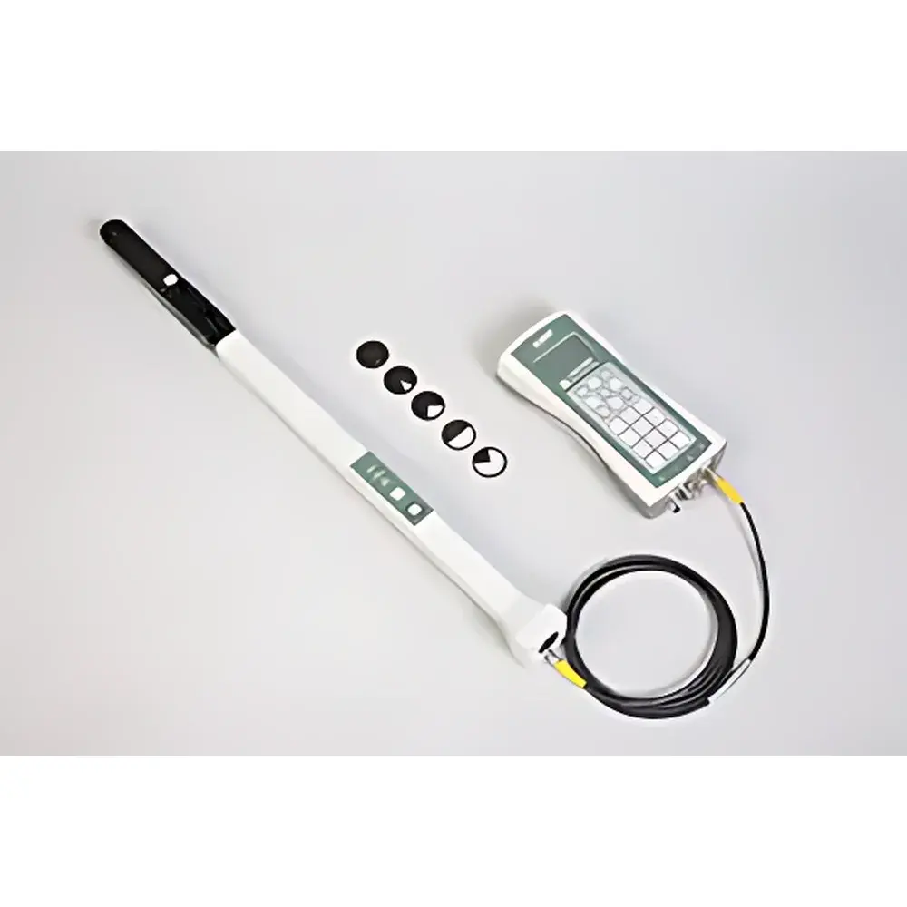
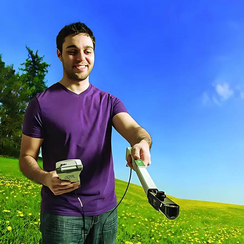
LI-COR LAI-2200C Canopy Analyzer
| Brand | LI-COR |
|---|---|
| Origin | USA |
| Model | LAI-2200C |
| Principle | Effective Radiation Transmission Measurement |
| Type | Portable |
| Spectral Response Range | 320–490 nm |
| Field of View | 148° vertical, 360° horizontal |
| GPS Module | Integrated GPS RADIONOVA® RF Antenna (CEP ≤ 2.5 m, update rate: 1 Hz, cold start TTFF ≤ 37 s) |
| Weight | 0.454 kg (main unit, with batteries), 0.845 kg (sensor probe, with batteries) |
| Battery Life | ≥40 h (main unit, GPS + sensor active), ≥180 h (probe, typical operation) |
| Operating Temperature | –20 to +50 °C |
| Relative Humidity | 0–95% RH (non-condensing) |
| Compliance | CE-marked, FCC Class B |
Overview
The LI-COR LAI-2200C Canopy Analyzer is a field-deployable, optical instrumentation system engineered for non-destructive, in situ quantification of structural and radiative properties of plant canopies. It operates on the principle of effective radiation transmission measurement—leveraging hemispherical (fisheye) optics and multi-angle diffuse light capture to resolve canopy architecture through radiative transfer modeling. Unlike empirical or single-angle methods, the LAI-2200C acquires simultaneous irradiance measurements at five discrete zenith angles (0°, 10°, 20°, 30°, and 40°) above and below the canopy, enabling robust estimation of leaf area index (LAI), mean tilt angle (MTA), gap fraction, and apparent clumping index (ACI) under variable sky conditions. Its integrated GPS module—based on the RADIONOVA® RF antenna platform—provides georeferenced timestamps and positional metadata essential for spatial interpolation, time-series analysis, and GIS integration. This capability ensures traceability and reproducibility across heterogeneous landscapes, supporting long-term ecological monitoring, agronomic trials, and forest inventory applications aligned with ISO 13837 and ASTM E2913 standards for vegetation structure characterization.
Key Features
- Fully integrated GPS subsystem with <2.5 m CEP accuracy (outdoor open-sky), 1 Hz position update rate, and WAAS support for enhanced satellite signal acquisition.
- Dual-sensor architecture: main control unit supports up to two LAI-2250 optical probes simultaneously—enabling paired above/below-canopy measurements and automated error propagation for LAI and MTA standard errors.
- Optimized fisheye optical design: 148° vertical × 360° horizontal field of view; MgF₂-coated lenses ensure high transmittance at oblique incidence and >99% rejection of radiation beyond 490 nm (critical for isolating photosynthetically relevant UV-A/blue spectral band).
- Low-power embedded architecture: main unit operates >40 hours on four AA alkaline cells; probe extends >180 hours on two AA cells—validated across –20 to +50 °C ambient range and 0–95% RH (non-condensing).
- Modular probe deployment: LAI-2250 sensors function autonomously with internal clock synchronization, enabling unattended, long-duration time-series measurements without host connection.
- Comprehensive accessory compatibility: direct interface with LI-COR radiation sensors (e.g., LI-190R PAR, LI-200R pyranometer, LI-210R lux meter) via BNC and 6-pin digital ports for multi-parameter environmental context.
Sample Compatibility & Compliance
The LAI-2200C is validated for use across all major vegetation types—including broadleaf and coniferous forests, agricultural row crops, grasslands, shrublands, and wetland emergent communities. Its 320–490 nm spectral response targets the region where leaf chlorophyll absorption and atmospheric Rayleigh scattering dominate, ensuring sensitivity to canopy density while minimizing interference from near-infrared reflectance. The instrument complies with CE marking requirements for electromagnetic compatibility (EMC Directive 2014/30/EU) and low-voltage safety (LVD Directive 2014/35/EU). Data acquisition workflows support GLP-compliant documentation: timestamped GPS coordinates, sensor serial IDs, calibration checksums (stored in EEPROM), and operator-defined metadata fields are embedded in raw binary files (.lai). Optional FV-2200 software enables audit-trail generation per FDA 21 CFR Part 11 when configured with electronic signatures and user access controls.
Software & Data Management
Data acquisition and post-processing are managed through the FV-2200 desktop application (Windows OS), which provides full support for multi-probe synchronization, sky condition classification (clear, partly cloudy, overcast), and iterative inversion of the Nilson–Goudriaan radiative transfer model. The software implements scatter-corrected LAI calculation using concurrent above-canopy sky measurements, eliminating reliance on empirical sky models. Export options include CSV, Excel, and ESRI Shapefile formats—with georeferenced LAI rasters compatible with ArcGIS and QGIS. Raw data files retain native precision (16-bit ADC resolution) and are structured to enable third-party algorithmic reprocessing. Firmware updates are delivered via USB and include cryptographic signature verification to ensure integrity and traceability.
Applications
- Long-term forest dynamics monitoring: tracking seasonal LAI phenology and interannual variability in response to drought, pest outbreaks, or climate shifts.
- Agronomic optimization: evaluating canopy closure timing, nitrogen-use efficiency, and planting density effects on light interception in maize, soybean, and rice systems.
- Ecological modeling input: generating spatially explicit LAI and clumping index maps for coupling with land surface models (e.g., CLM, Noah-MP) and remote sensing validation campaigns.
- Carbon flux partitioning: constraining GPP estimates by linking LAI-derived fAPAR (fraction of absorbed photosynthetically active radiation) with eddy covariance tower data.
- Restoration ecology: quantifying structural recovery trajectories in post-fire or post-mining sites using standardized, repeatable ground-truth metrics.
FAQ
How does the LAI-2200C correct for diffuse skylight under cloudy conditions?
It uses synchronized above-canopy measurements from a second LAI-2250 probe (or optional sky sensor) to characterize the angular distribution of diffuse irradiance, enabling physics-based correction of transmitted fluxes without assuming clear-sky models.
Can the LAI-2200C be used in dense understory or multi-layered canopies?
Yes—the five-angle measurement protocol and gap fraction analysis accommodate vertically stratified canopies; however, interpretation requires careful probe placement to avoid occlusion artifacts and adherence to standardized protocols (e.g., ISO 13837 Annex B).
Is firmware and software support available for legacy operating systems?
FV-2200 v4.2+ requires Windows 10 or later; firmware updates are distributed exclusively through LI-COR’s secure customer portal with SHA-256 hash verification.
What calibration maintenance is required?
Factory calibration is stored in EEPROM and persists for the sensor’s operational lifetime; field verification is recommended annually using the supplied neutral-density reference cap and documented in the instrument log per ISO/IEC 17025 guidelines.
Does the system support real-time data streaming?
No—data are stored internally (128 MB flash on main unit, 1 MB on probe) and transferred post-survey via USB; this architecture prioritizes power efficiency and field robustness over live telemetry.