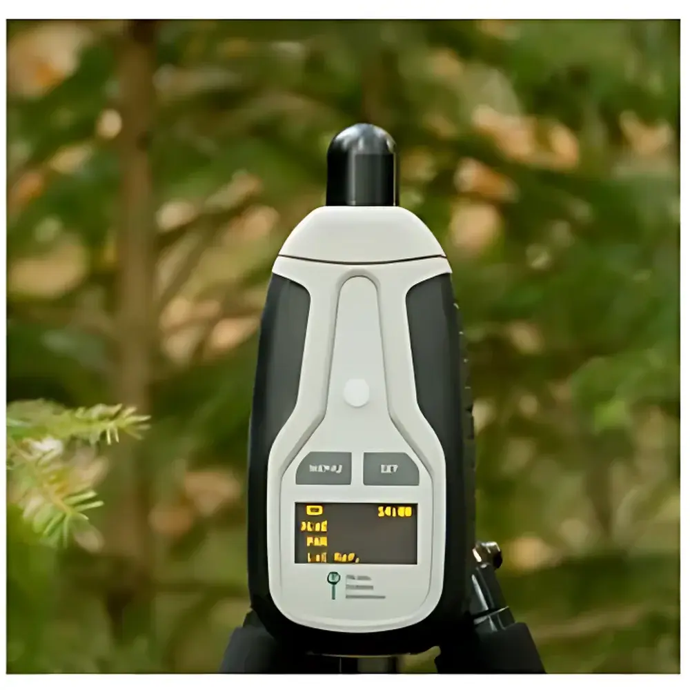
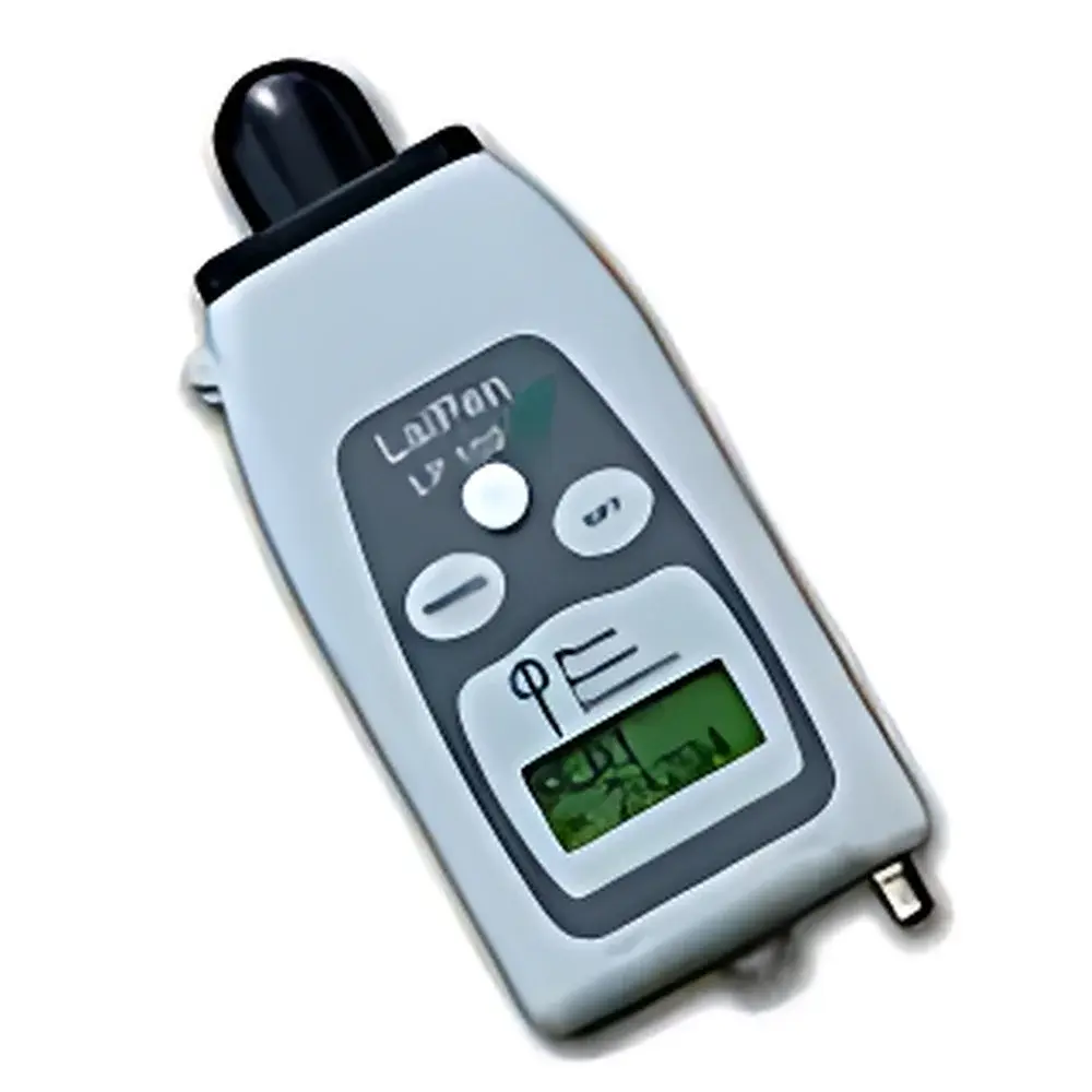
PSI LaiPen LP100 Leaf Area Index Meter
| Brand | PSI |
|---|---|
| Origin | Czech Republic |
| Model | LaiPen LP100 |
| Measurement Parameters | Leaf Area Index (LAI), Photosynthetically Active Radiation (PAR) |
| Detector Wavelength Range | 400–700 nm (PAR), 400–500 nm (LAI) |
| Field of View | 112° horizontal, 16° vertical |
| Measurement Angles | 0°, 16°, 32°, 48°, 64° |
| Memory Capacity | 4 MB (>100,000 data points) |
| Display | 2×8 character LCD |
| Battery Life | 48 hours |
| Dimensions | 120 mm × 57 mm × 30 mm |
| Weight | 180 g |
| Operating Temperature | 0–55 °C |
| Relative Humidity | 0–95% RH (non-condensing) |
| Storage Conditions | −10–60 °C, 0–95% RH (non-condensing) |
Overview
The PSI LaiPen LP100 Leaf Area Index Meter is a field-deployable optical instrument engineered for rapid, non-destructive estimation of Leaf Area Index (LAI) and Photosynthetically Active Radiation (PAR) transmission through plant canopies. LAI—defined as the one-sided green leaf area per unit ground surface area (m² m⁻²)—is a critical biophysical parameter in ecosystem modeling, carbon flux analysis, and agronomic monitoring. Unlike traditional hemispherical photography or indirect LAI estimation methods requiring overcast skies or precise solar zenith angles, the LaiPen LP100 employs a calibrated wide-angle optical sensor operating on the principle of gap fraction analysis within radiative transfer theory. By acquiring five angular measurements (0°, 16°, 32°, 48°, and 64° from nadir) both above and below the canopy, the device quantifies light interception across multiple incidence angles and solves the Beer–Lambert–Lacaze equation under assumptions of random leaf orientation and uniform extinction coefficient. This enables robust LAI derivation independent of sky conditions—making it suitable for diurnal surveys, heterogeneous stands, and long-term ecological observatories.
Key Features
- Compact monolithic design integrating detector, microcontroller, memory, and display in a palm-sized housing (120 × 57 × 30 mm; 180 g)
- Dual-band optical detection: 400–700 nm bandpass filter for PAR quantification and 400–500 nm bandpass for LAI-specific spectral weighting
- Five-angle measurement protocol aligned with standard canopy radiation models (e.g., SAIL, 4SAIL)
- Two operational modes: single-sensor sequential measurement (reference + sample) or dual-sensor synchronous acquisition for real-time normalization
- Onboard 4 MB flash memory supporting >100,000 timestamped data points with user-configurable logging intervals
- Optional GPS module integration for georeferenced LAI mapping compatible with GIS workflows
- Flexible connectivity: USB 2.0 for bulk data export and Bluetooth 4.2 for real-time telemetry and remote configuration via mobile applications
- Extended battery life (48 h continuous operation) with low-power sleep mode and auto-shutdown functionality
Sample Compatibility & Compliance
The LaiPen LP100 is validated for use with broadleaf canopies—including deciduous forests, agricultural crops (e.g., maize, soybean, vineyards), and shrubland ecosystems—where leaf inclination distributions approximate spherical randomness. It is not recommended for highly clumped coniferous stands without empirical correction factors. The instrument complies with IEC 60529 IP54 ingress protection standards for dust and splash resistance. Its optical calibration traceability follows ISO/IEC 17025-accredited procedures performed at PSI’s Prague metrology laboratory. Data output formats adhere to FAO-recommended metadata conventions for vegetation indices, supporting interoperability with global networks such as FluxNet, NEON, and ICOS. While not certified for GLP/GMP-regulated trials, its audit-ready data logs (including timestamps, sensor IDs, and environmental flags) meet minimum requirements for peer-reviewed ecological field studies.
Software & Data Management
Data retrieval and post-processing are supported via PSI’s proprietary LaiPen Manager desktop application (Windows/macOS), which provides visualization of angular transmittance curves, LAI convergence diagnostics, and PAR attenuation profiles. Export options include CSV, NetCDF-4, and GeoJSON formats—with optional inclusion of GPS coordinates, UTC timestamps, and instrument firmware version. The software implements automated QA/QC routines including outlier detection based on signal-to-noise ratio thresholds and consistency checks across angular sequences. All raw sensor readings and derived parameters are stored with immutable metadata headers, satisfying FAIR (Findable, Accessible, Interoperable, Reusable) data principles. For institutional deployments, the system supports integration with enterprise-level data lakes via RESTful API endpoints compliant with OGC SensorThings API v1.1 specifications.
Applications
- Long-term monitoring of canopy structural dynamics in response to climate variability, drought stress, or phenological shifts
- Ground-truthing and validation of satellite-derived LAI products (e.g., MODIS MCD15A3H, Sentinel-3 OLCI)
- Quantifying canopy closure effects on understory microclimate, evapotranspiration, and soil moisture retention
- Evaluating pest infestation or pathogen-induced defoliation using time-series LAI anomaly detection
- Supporting eddy covariance tower footprint analysis by spatially constraining effective LAI within flux source areas
- Calibrating process-based vegetation models (e.g., LPJ-GUESS, ORCHIDEE) with empirically constrained structural inputs
FAQ
Does the LaiPen LP100 require calibration before each use?
No—factory calibration is stable for ≥12 months under normal field conditions. Users may perform optional field verification using the included neutral density reference cap.
Can the device measure LAI in dense coniferous forests?
It can acquire data, but LAI values require species-specific correction factors due to non-random needle orientation and high clumping indices; refer to PSI Application Note AN-LAI-07 for guidance.
Is the instrument compatible with third-party GIS or statistical platforms?
Yes—CSV and NetCDF exports support direct ingestion into R (raster, terra), Python (xarray, pandas), ArcGIS Pro, and QGIS via standardized coordinate reference system (WGS84) tagging.
What is the minimum detectable LAI value?
The lower limit of reliable detection is LAI ≈ 0.3, constrained by sensor noise floor and angular sampling resolution—not instrument specification.
How does the dual-sensor mode improve measurement accuracy?
Simultaneous above- and below-canopy acquisition eliminates temporal drift in sky radiance, particularly during rapidly changing illumination (e.g., passing clouds), reducing uncertainty in gap fraction estimation by up to 35% compared to sequential mode.
Related Products