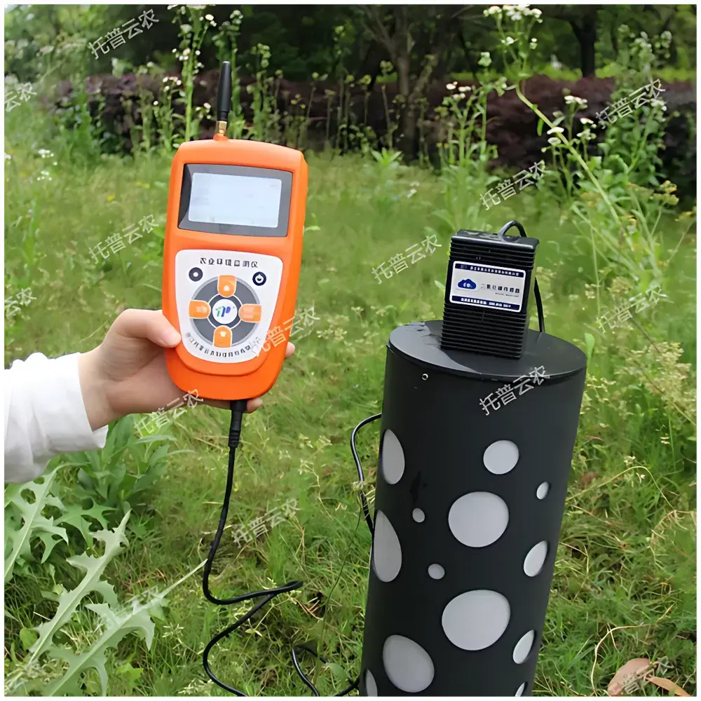
Top Cloud-agri TPJ-26-IG Portable CO₂ Analyzer
| Brand | Top Cloud-agri |
|---|---|
| Origin | Zhejiang, China |
| Manufacturer Type | Manufacturer |
| Model | TPJ-26-IG |
| Instrument Type | Portable |
| Measurement Range | 0–2000 ppm |
| Resolution | 1 ppm |
| Accuracy | ±(50 ppm + 3% of reading) |
| Power Supply | 7.4 V / 2.8 Ah Li-ion battery |
| Data Storage | 30,000 records in internal Flash + optional 4 GB microSD card |
| Communication | 2G/4G cellular, GPS, USB |
| Sampling Method | Diffusion-based, no flow control or temperature compensation required |
Overview
The Top Cloud-agri TPJ-26-IG Portable CO₂ Analyzer is a non-dispersive infrared (NDIR) gas detection instrument engineered for field-deployable, real-time quantification of carbon dioxide concentration in ambient air. It operates on the fundamental principle of Beer-Lambert absorption spectroscopy: CO₂ molecules exhibit strong and characteristic absorption at 4.26 µm wavelength; the analyzer directs an infrared beam through a diffusion-sampling optical cell, where attenuation of the signal—measured by a thermopile detector behind a narrow-band interference filter—is directly proportional to CO₂ partial pressure. Unlike extractive systems requiring pumps, flow regulation, or active temperature stabilization, the TPJ-26-IG employs passive diffusion sampling and factory-calibrated thermal drift compensation, enabling immediate operation upon power-up with no user calibration or zero-point adjustment. Its design prioritizes operational robustness in variable environmental conditions while maintaining metrological integrity across its full 0–2000 ppm range—suitable for indoor air quality (IAQ) assessment, agricultural microclimate monitoring, and industrial safety screening.
Key Features
- True plug-and-play operation: No flow controller, no manual temperature compensation, no cross-sensitivity calibration required—ready to measure within seconds of startup.
- Integrated dual-mode wireless connectivity: Simultaneous 2G/4G cellular uplink and GPS geotagging enable automatic, timestamped data transmission to cloud infrastructure with location metadata.
- Dual-storage architecture: 30,000 measurement records retained in onboard Flash memory; expandable via removable 4 GB microSD card for continuous long-term logging without data loss.
- Low-power embedded system: Average standby current consumption ≤10 mA; intelligent power management extends battery life to >72 hours under typical 15-minute sampling intervals.
- Multi-sensor expandability: Modular bus interface supports up to 32 heterogeneous sensor types (e.g., CO, O₂, RH/T, NH₃) via IP67-rated daisy-chain cabling—each channel maintains independent calibration traceability.
- Voice-enabled interface: Configurable Mandarin voice prompts for status, measurement values, and programmable alarm thresholds—including audible over-limit warnings.
- On-device display: Backlit monochrome LCD showing real-time CO₂ value, UTC timestamp, GPS coordinates, battery level, and storage utilization.
Sample Compatibility & Compliance
The TPJ-26-IG is validated for use in non-corrosive, non-condensing gaseous environments with ambient temperatures from −10 °C to +50 °C and relative humidity ≤90% RH (non-condensing). It complies with IEC 61000-6-3 (EMC emission standards) and IEC 61000-6-2 (immunity requirements) for portable instrumentation. While not certified to ATEX or IECEx for hazardous area use, its NDIR sensing architecture inherently avoids catalytic or electrochemical hazards—making it appropriate for general industrial hygiene applications per OSHA 29 CFR 1910.1200 and EU Directive 2004/37/EC (CARC) exposure assessment workflows. Data integrity aligns with GLP principles: all measurements include embedded UTC timestamps, GPS coordinates, and device serial identifiers—enabling audit-ready traceability in regulated agricultural and food processing settings.
Software & Data Management
The instrument interfaces natively with the Top Cloud-agri Instrument Cloud Platform—a secure, multi-tenant SaaS environment accessible via web browser (Chrome/Firefox/Edge) or native iOS/Android applications. The platform implements role-based access control (RBAC), encrypted HTTPS transport (TLS 1.2+), and local database redundancy. Each uploaded record includes CO₂ value, acquisition time (ISO 8601), WGS84 latitude/longitude, sensor ID, and firmware version. Analytical tools include time-series trend visualization, statistical summary (min/max/mean/std dev), threshold-based alerting, and export to CSV/PDF/Excel formats. All data modifications are logged with user ID and timestamp, satisfying basic ALCOA+ (Attributable, Legible, Contemporaneous, Original, Accurate, Complete, Consistent, Enduring, Available) expectations for QA/QC documentation in agri-food supply chain monitoring.
Applications
- Agricultural controlled-environment agriculture (CEA): Continuous CO₂ dosing verification in greenhouses and mushroom cultivation facilities—where elevated CO₂ (800–1200 ppm) enhances photosynthetic efficiency and crop yield.
- Food storage & processing: Monitoring headspace CO₂ levels in modified-atmosphere packaging (MAP) lines, cold storage rooms, and fermentation tanks to ensure microbial inhibition and shelf-life extension.
- Indoor air quality (IAQ) auditing: Occupancy-based ventilation assessment in schools, offices, and healthcare facilities per ASHRAE Standard 62.1 and EN 16798-1 compliance frameworks.
- Post-harvest logistics: Spot-checking CO₂ accumulation in refrigerated maritime containers transporting perishables—critical for preventing anaerobic spoilage and ethylene-driven ripening acceleration.
- Environmental education & citizen science: Field-based atmospheric CO₂ mapping in urban parks, forest edges, and campus microclimates using GPS-tagged transect data.
FAQ
Does the TPJ-26-IG require periodic calibration?
No routine field calibration is required. The NDIR optical path is factory-calibrated against NIST-traceable reference gases. Users may perform functional verification using ambient air (≈400 ppm) or certified span gas (e.g., 1000 ppm CO₂ in N₂) as needed.
Can the device operate continuously while charging?
Yes—the internal charging circuit supports simultaneous measurement and battery replenishment when connected to the 8.4 V DC input. Battery protection logic prevents overcharge and deep discharge.
Is the GPS module active during data logging only, or does it run continuously?
GPS acquires position once per measurement cycle (configurable interval) and embeds coordinates into each record. It powers down between acquisitions to conserve energy.
What file formats are supported for data export from the cloud platform?
CSV (for spreadsheet analysis), PDF (formatted reports), and Excel (.xlsx) with embedded charts and metadata columns.
How is data security ensured during cellular transmission?
All 2G/4G transmissions use TLS 1.2 encryption; device authentication employs unique X.509 certificates provisioned at manufacture; no credentials are stored on the instrument.
Related Products