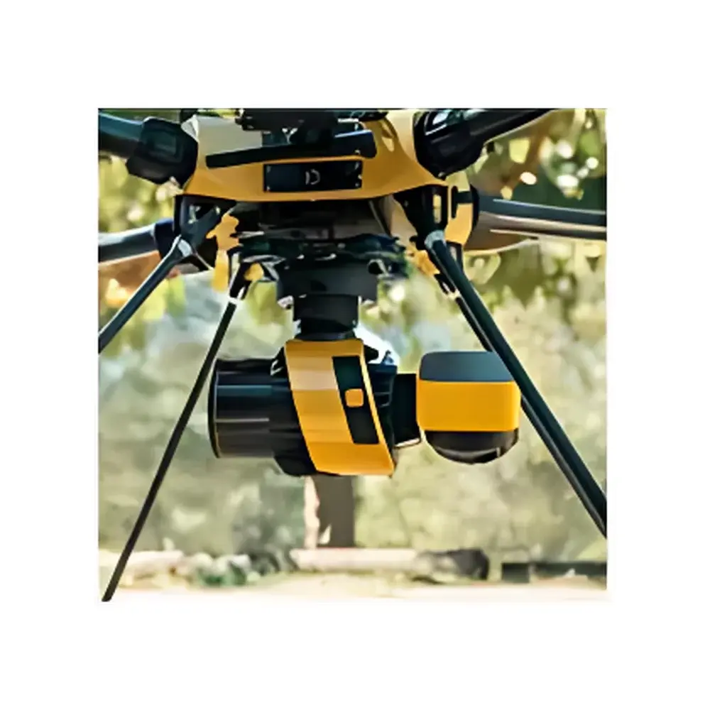
Yellowscan Surveyor Ultra Airborne & Terrestrial LiDAR System
| Brand | Yellowscan |
|---|---|
| Origin | France |
| Model | Surveyor Ultra |
| Weight | 983 g |
| GNSS/IMU | SBG Systems integrated high-precision inertial navigation unit |
| Laser Scanner FOV | 360° × 40.3° |
| Data Rate | 640 kHz |
| RGB Camera | Embedded 2 MP global-shutter color camera (standard) |
| Optional RGB Configurations | Nadir-only or nadir + oblique dual-camera rig, factory-calibrated |
| Vertical Accuracy (at 100 m AGL) | < 2.5 cm (absolute), < 3 cm (relative) |
| Platform Compatibility | UAV (e.g., DJI Matrice series, Ecodrone® UAS-8/UAS-8 Pro), ground vehicle mounts |
| Software Suite | YellowScan Georeferencing Studio (YGS), supports point cloud coloring, classification, DSM/DTM/DHM generation, and export to industry-standard formats (LAS/LAZ, E57, PLY, XYZ) |
Overview
The Yellowscan Surveyor Ultra is a dual-mode airborne and terrestrial LiDAR system engineered for high-fidelity geospatial data acquisition across diverse operational environments. Built upon the principles of time-of-flight (ToF) pulsed laser ranging, the system integrates a 360° rotating LiDAR scanner with a tightly coupled SBG high-accuracy GNSS/IMU navigation unit—ensuring robust georeferencing even under dynamic platform motion and partial GNSS signal degradation. Unlike legacy scanning architectures constrained by mechanical limitations or narrow field-of-view optics, the Surveyor Ultra delivers continuous omnidirectional coverage (360° horizontal × 40.3° vertical FOV) at a sustained 640 kHz pulse repetition rate, enabling dense point cloud generation (>200 pts/m² at 100 m altitude) without interpolation artifacts. Its sub-3 cm relative and sub-2.5 cm absolute vertical accuracy—validated per ISO 19157:2013 (Geographic Information — Data Quality) and aligned with ASPRS Positional Accuracy Standards for Digital Geospatial Data—makes it suitable for applications requiring metrological traceability in environmental monitoring, topographic surveying, and change detection workflows.
Key Features
- Lightweight modular architecture (983 g total mass), optimized for Class I/II UAV platforms and compact ground-based mobile mapping systems
- Fully integrated SBG inertial navigation system with real-time kinematic (RTK) GNSS support, delivering centimeter-level trajectory reconstruction
- Embedded 2 MP global-shutter RGB camera synchronized to LiDAR pulses at hardware level, ensuring geometrically consistent color attribution for every returned echo
- Factory-calibrated multi-sensor alignment (LiDAR–IMU–RGB), eliminating post-mission boresight estimation for rapid processing
- Optional nadir-only or nadir + oblique dual-RGB configuration, supporting true orthophoto generation and enhanced 3D feature interpretation
- Industrial-grade thermal management and IP54-rated enclosure, certified for operation in ambient temperatures from –10 °C to +50 °C
Sample Compatibility & Compliance
The Surveyor Ultra is designed for deployment on both aerial and terrestrial mobile platforms without hardware modification. It has been validated on Ecodrone® UAS-8 and UAS-8 Pro UAVs, DJI Matrice 300 RTK and M600 Pro platforms, as well as standard automotive roof racks equipped with vibration-damping mounts. All calibration procedures follow NIST-traceable methodologies, and sensor fusion algorithms comply with ISO/IEC 17025:2017 requirements for testing and calibration laboratories. The system meets CE marking directives (2014/53/EU, 2014/30/EU) and conforms to EN 61000-6-2 (immunity) and EN 61000-6-4 (emissions) standards. For regulated environmental monitoring programs, raw and processed datasets generated using YellowScan Georeferencing Studio maintain full audit trails compliant with ISO 14001:2015 and EU Regulation (EC) No 1272/2008 (CLP) reporting frameworks.
Software & Data Management
YellowScan Georeferencing Studio (YGS) is a purpose-built desktop application supporting end-to-end processing of Surveyor Ultra data streams. YGS implements rigorous GNSS/IMU post-processing (PPK) using open-source RTKLIB libraries, followed by iterative closest point (ICP)-assisted trajectory refinement and multi-station tie-point registration. Point cloud classification adheres to ASPRS LAS 1.4 specification classes, including automated ground/non-ground separation via progressive morphological filtering. Output deliverables include classified LAS/LAZ files, georeferenced DSM/DTM rasters (GeoTIFF), hydro-enforced DHM models, and colorized point clouds with radiometrically balanced RGB attributes. All processing steps are logged with timestamps, user IDs, and parameter configurations—enabling full GLP-compliant documentation for regulatory submissions and peer-reviewed publication workflows.
Applications
- Forest structure analysis: canopy height modeling (CHM), biomass estimation, and understory penetration assessment in mixed-species stands
- Coastal erosion monitoring: decimeter-scale change detection across intertidal zones using multi-temporal DTM differencing
- Post-wildfire terrain assessment: burn severity mapping via normalized burn ratio (NBR) integration with structural metrics derived from classified point clouds
- Urban infrastructure inventory: precise extraction of power lines, rail corridors, and building façades under complex occlusion conditions
- Geomorphological surveying: high-resolution river channel bathymetry (in conjunction with multispectral water-penetration correction) and landslide displacement vector analysis
- Environmental compliance auditing: verification of reclamation progress against pre-disturbance baselines in mining and construction sites
FAQ
Does the Surveyor Ultra support real-time kinematic (RTK) positioning during flight?
Yes—the system accepts external RTK corrections via UART or Ethernet interfaces and supports concurrent PPK/RTK hybrid workflows for redundancy-critical missions.
Can raw LiDAR and RGB data be exported separately for third-party processing?
Absolutely. Binary .bin files containing unprocessed echoes, IMU logs (.imu), GNSS observations (.obs), and JPEG/TIFF imagery are accessible via USB-C interface prior to YGS ingestion.
Is firmware update capability available over-the-air (OTA)?
Firmware updates require local connection via USB-C and are distributed through YellowScan’s secure customer portal, with SHA-256 checksum verification and version-controlled release notes.
What coordinate reference systems (CRS) are supported in YGS output?
YGS natively supports WGS84 (EPSG:4326), ETRS89 (EPSG:4258), and user-defined projected CRS—including UTM variants, State Plane Coordinates, and national grid systems—with automatic datum transformation using PROJ 8.x libraries.
How is radiometric calibration of the embedded RGB camera performed?
Each unit undergoes factory-based flat-field correction and spectral response characterization using NIST-traceable integrating sphere illumination, with per-pixel gain/offset maps stored in non-volatile memory and applied automatically during image capture.


